October 15, 2019
Retracing Lena Huppler Bevers’ Travel Log
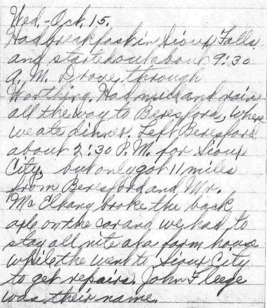
Wed. – Oct. 15.
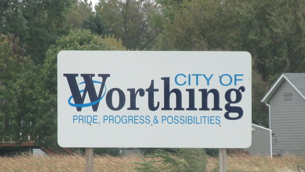
Had breakfast in Sioux Falls and started out about 9:30 A. M. Drove through Worthing. Had mud and rain all the way to Beresford, where we ate dinner. Left Beresford about 2:30 P. M. for Sioux City, but only got 11 miles from Beresford and Mr. McElhany broke the back axle on the car and we had to stay all nite at a farm house while [they] went to Sioux City to get repairs. John Fleege was their name. – Lena Bevers
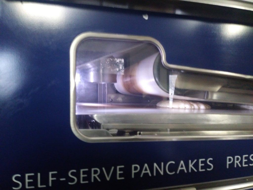
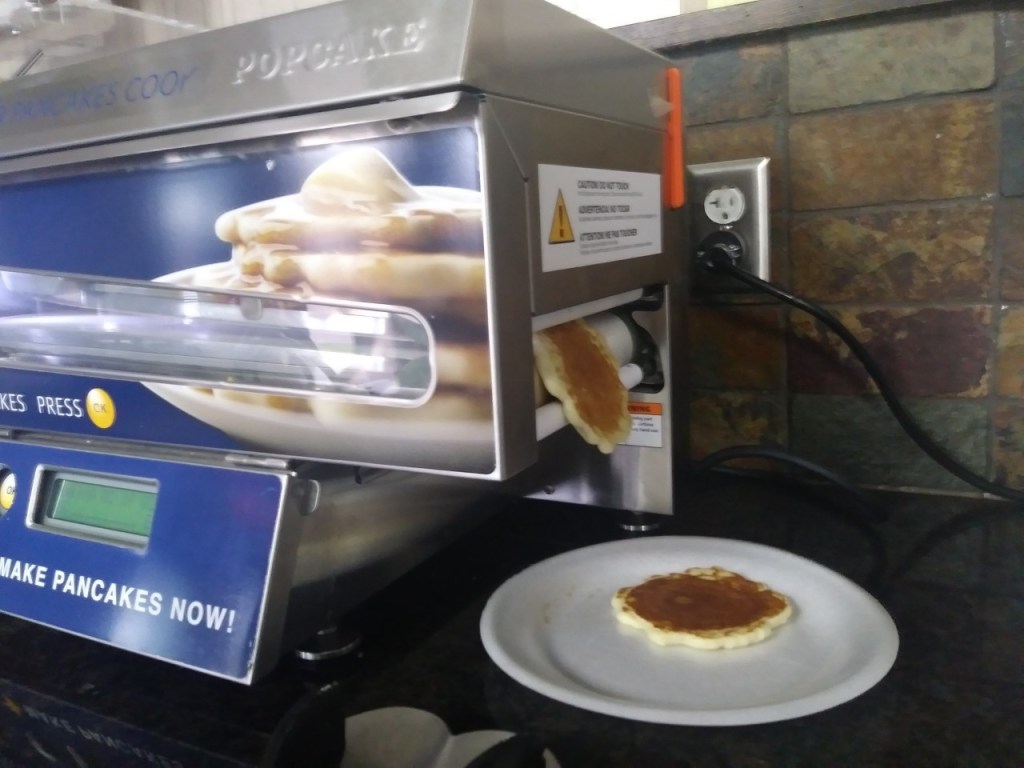
Lena begins this day’s log entry by saying they had breakfast in Sioux Falls. My mother and I stayed the night at a motel in Sioux Falls that provided a large selection of breakfast items. On the counter, I saw a machine that I had never seen before. It was a self-serve pancake machine, so I decided to see how the machine works. After dropping pancake batter on a conveyor belt, the uncooked pancake slides through two heated panels, one above and one underneath. In one minute, the pancake is cooked on both sides and slips out of the side of the machine. It’s fun to watch and the pancakes were delicious.
A few days ago, I received an email from my bank, saying that they needed me to submit a document. While in Watertown, because I didn’t want to access my online bank account using a public Wi-Fi connection, I had downloaded the document from my online bank account using our cousin’s computer, saving it to a USB drive. Our motel has a computer and printer available to its guests, so I printed the document yesterday afternoon. This morning I spent about 20 minutes on the phone with the bank (most of the time on hold), discussing exactly how they wanted me to fill out the form. Having accomplished that, we located a shipping company where I could fax the document to the bank. I relate all of this to record some of the ways I handle communication and banking while traveling – ways that are different from Lena and Herbert’s experience.
Before departing our motel this morning, we had a visit in the motel lobby with a cousin who lives in Sioux Falls. Then we prepared to leave. Herbert and Lena only traveled about 40 miles on their third day, so we waited at the motel until nearly check-out time at 11:00 AM.
Referring again to the 1925 Touring Map of the Custer Battlefield Hiway, there is a highway with the number 20 that heads directly south out of Sioux Falls.1 This number does not indicate a highway number, it is a reference to the numbering system in the map legend. On a 1919 automobile route map of Iowa, this same route is given the number 105 to coincide with that map’s legend.2 This route is the King of Trails highway, which is another transcontinental highway. Its northern terminal point is Winnipeg, Manitoba (the same as the Meridian Highway), which in the early nineteen hundreds was the third largest city in Canada and a major agricultural and railway center.3 The southern terminals are Galveston, Texas (also the same as the Meridian Highway) and Brownsville, Texas. So, running through the central plains of the United States, these two transcontinental highways were parallel.
When Lena and Herbert were traveling to Texas, the roads were not yet numbered by the federal, state or county governments. Routes were determined initially by local automobile organizations, then later as automobile tourists began taking longer excursions, the routes were established by coalitions of associations or individuals of many localities.
In 1917 the King of Trails Association was organized. An article in The Parsons Daily Sun describes the association as follows:
“It is a nation wide civic organization with a membership embracing big public spirited men from every walk of life — bankers, merchants, automobile dealers, etc.
“The primary object of this institution has been the promotion of good roads and the general welfare of the communities through which the Highway passes.”4
One of the responsibilities of the King of Trails Association was the marking of the route. The organization proudly announced its accomplishment:
“The King of Trails is one of the best and most consistently marked highways in existence, there being on the entire route upwards of 14,000 painted poles that guide the stranger in a strange land. This year’s program calls for the remarking of the trail wherever necessary and the erection of danger signs at every grade crossing and other dangerous points on the entire highway. Particular attention will be paid to the marking of the highway through towns and cities.”5
My mother and I have several resources to help us decide our route each day: sheet maps, electronic maps, navigational devices. How did Herbert determine where to drive?
“With the increasing popularity of automobile touring came a pressing need for navigational aids, because during the early 1900s, geographic route-finding knowledge was primarily local. People knew how to navigate on foot or by horse and buggy within their local town or county using the mental map that they had acquired through experience. Because people relied on mental maps, road signs were not needed; thus signage was rarely a feature in the landscape. If someone wanted to travel farther than a day’s carriage ride, he or she usually did so by railroad. There was no need, for instance, to know how to navigate from Chicago to St. Louis because the train did all the navigating and ‘driving.’ However, a locally based mental map was insufficient for navigating by automobile. There were no road maps and few road signs, so how would someone know which roads to take? In which direction would one travel? Where would one turn?
“This problem of navigation, or finding one’s way, by automobile during the early years of the last century prompted entrepreneurial automobilists to create route guides. These guides helped early automobile tourists navigate through unfamiliar territory by collecting localized directional information and presenting it in a form usable to outsiders. Automobile clubs, highway associations, and other related organizations published or sponsored route guides during these years….”6
The Official Automobile Blue Book which used the tag line ‘Standard Road Guide of America,’ was the most popular set of touring books in the early 1900s. It provided drivers with written directions to travel between cities and towns at a time when roads were not yet designated with highway numbers and road signs. Sets of these touring books began to be published in 1901 with the purpose “to promote touring by establishing routes that connected automobile ‘supply stations.’”7
By 1917 there were 10 volumes in the set of The Official Automobile Blue Book. I was able to locate volume 5 of the 1917 edition on the Internet Archive website. It is not known whether Herbert and Lena had a tour book to follow, but as we attempt to retrace their route to Texas, we will be referring to this tour book. Route 919 in volume 5 has route directions from Sioux Falls to Sioux City. The book describes the route as: “Good dirt practically all the way, will be bad in wet weather. This is an option to Route 918. It is approximately 10 miles shorter and will probably be the best road in dry weather.”8 Unfortunately, Lena and Herbert did not have dry weather the day they left Sioux Falls. Lena recounts that they drove through “mud and rain all the way to Beresford,” driving through Worthing along the way.
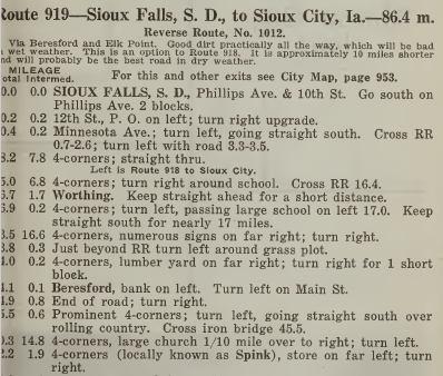
The Blue Book directions above say to exit Sioux Falls on Minnesota Avenue (Highway 115), which is the road my mother and I started out on today. Just a few miles down the road Highway 115 had a detour, taking us to Interstate Highway 29. We did not want to take an interstate highway, so we took Louise Avenue (Highway 117) instead. It took us directly south to Worthing and also took us to Beresford.
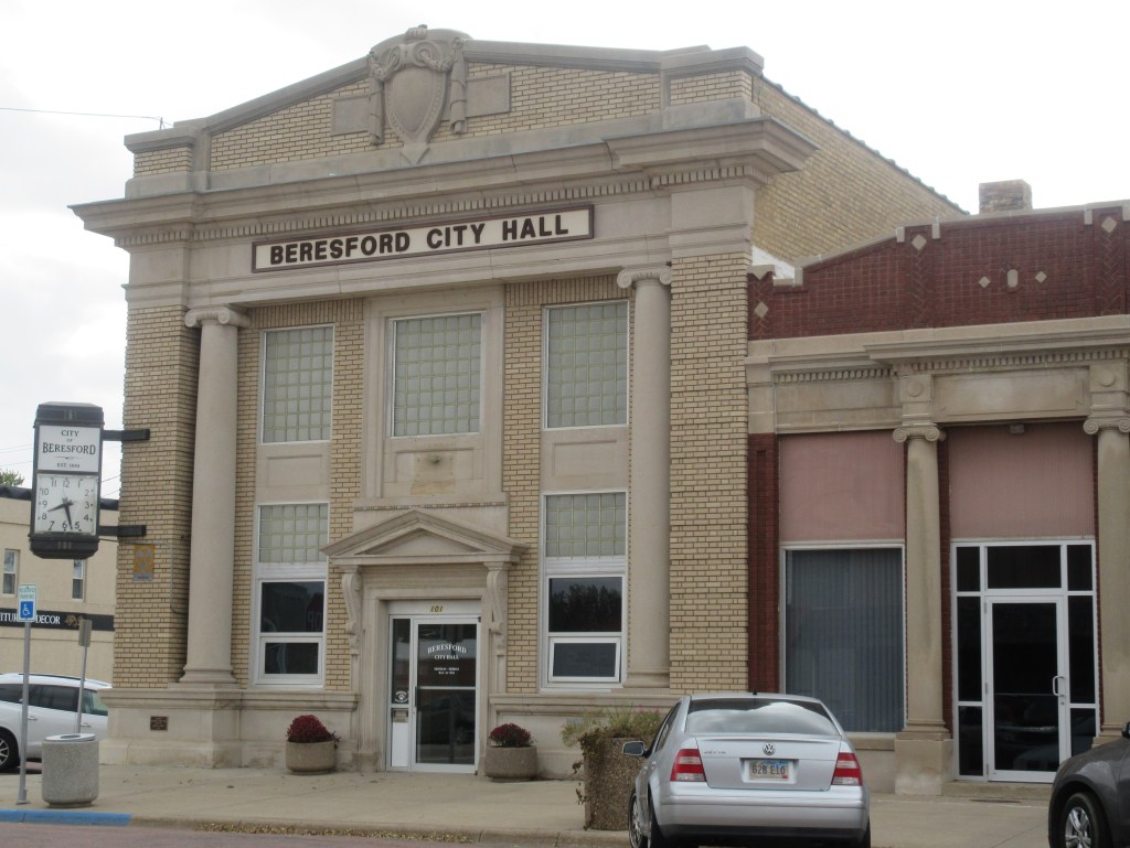
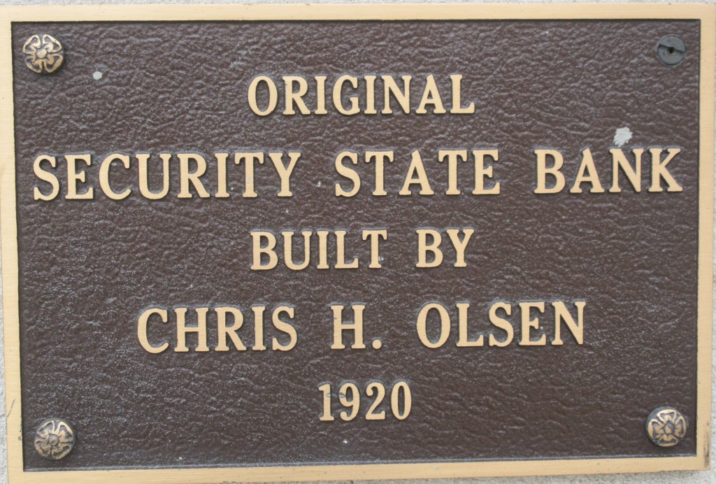
After dinner, the traveling party headed south, planning to make it to Sioux City, but about 11 miles south of Beresford, an axle broke on Mr. McElhany’s car. Lena and her children “had to stay all night at a farm house while the men went to Sioux City to get repairs.” Lena’s daughter reports in her travel log that the men “could not get the right axle.”11 My mother and I started down Highway 117, but only a couple miles down the road, it turned to a gravel road and we decided not to continue on that route. The Bevers Family stayed at the farm house of John Fleege. Instead of finding a farmer to take us in, we are staying at a motel in Beresford. We checked-in at 2:00 PM.
Notes:
- John C. Mulford and C. C. Faunce, Touring map of the Custer Battlefield Hiway: the scenic route to the west. [S.l, 1925] Map. https://www.loc.gov/item/99466708/.
- The Kenyon Company, Map of Iowa showing principal automobile routes (Des Moines, Iowa: The Kenyon Company, 1919): https://commons.wikimedia.org/wiki/File:Map_of_Iowa_Showing_Principal_Automobile_Routes.jpg.
- David Moore, et al., The Meridian Highway in Texas (Austin, Texas: Texas Historical Commission, May 27, 2016): 1.
- “Parsons National Headquarters, King of Trails Highway Ass’n,” The Parsons Daily Sun, February 18, 1922: 4, http://bikeallencounty.org/news/king-trails-highway/.
- “Parsons National Headquarters, King of Trails Highway Ass’n”: 5.
- John T. Bauer, “The Official Automobile Blue Book, 1901-1929: Precursor to the American Road Map,“ Cartographic Perspectives No. 62, Winter 2009: 5, http://www.scottbicknell.com/wp-content/uploads/2016/12/Route_Book_Article_182-1158-1-PB.pdf.
- Bauer, “The Official Automobile Blue Book, 1901-1929: Precursor to the American Road Map”: 11.
- Automobile Blue Book Publishing Company, Official Automobile Blue Book 1917, vol. 5 (New York: Automobile Blue Book Publishing Company, 1917): 971, https://ia800405.us.archive.org/15/items/case_gv1024_a92_1917_vol_5/case_gv1024_a92_1917_vol_5.pdf.
- David Erpestad and David Wood, Building South Dakota (Pierre, South Dakota: South Dakota State Historical Society Press): 148.
- Jane Norling, “Library looking for history,” Beresford Republic, date unknown.
- B. Winkelmann, Our Trip to Texas [Transcription of Our Trip to Texas by Florence Bevers, 1919] (unpublished, n. d.): 1.

I can only guess at the amount of time and research you have put into this. Enjoying every word and picture of it. Keep it coming. It will be a great piece to pass on. Be safe! From brother and Uncle Bob.
________________________________
LikeLike
I started researching over a year ago. I’m very happy to have the opportunity to share what I have learned. Glad you are enjoying it.
LikeLike