Were still at Fleeges while they were fixing the car. Stayed all day Thursday and over night. – Lena Bevers
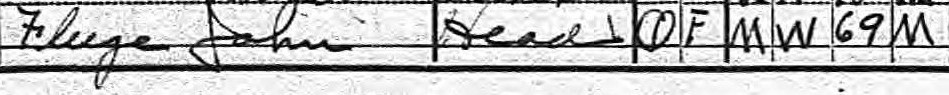
Since Herbert and Mr. McElhany could not get the right axle in Sioux City, Florence reported that on Thursday morning, “Rob and Roy Fleege had to go to Beresford and have one made, did not get back until Friday morning.”1 The man named Rob that she mentions apparently is not a member of the Fleege family, because on the 1920 U. S. Census for Emmet Township, Union County, South Dakota there is no Rob (or any variation of Rob) listed in the family.2 Also, Rob is not Mr. McElhany because in the travel logs for the next day, both Lena and Florence state that “Pa and Mr. McElhany went to Beresford to get Rob.”3 This is strong evidence that there is an additional member of the traveling party.
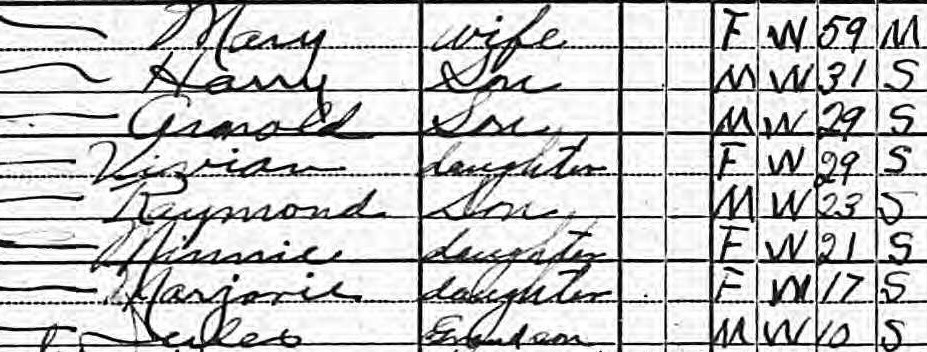
1920 U. S. Census record of the John Fleege family
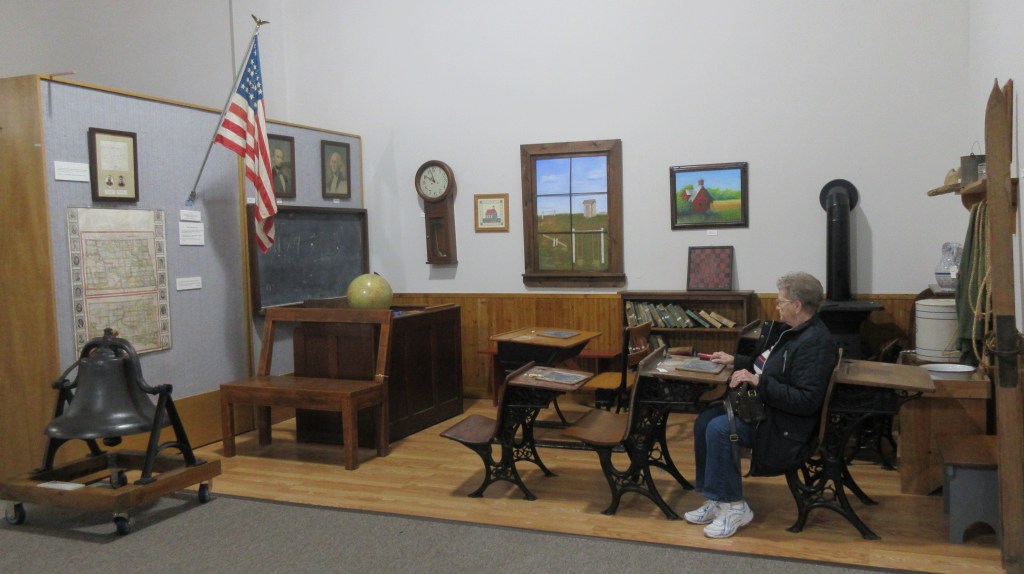
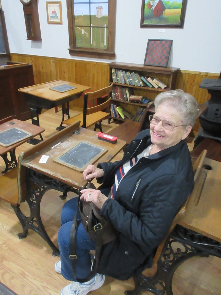
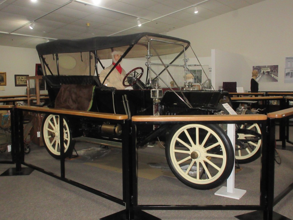
In order to fill our time today, my mother and I decided to visit the W. H. Over Museum in Vermillion. We spent an enjoyable hour wandering through the historical and cultural exhibits. One of the exhibits brought back memories to my mother of her days at a one-room rural school in Grover, South Dakota. There was also an antique automobile. It isn’t the model that Herbert Bevers nor Mr. McElhany were driving. According to one of Herbert’s grandsons, Herbert was driving a Model A Ford and Mr. McElhany was driving an Overland.4
(Photos by MRW October 16, 2019)
(Photos by MRW October 16, 2019)
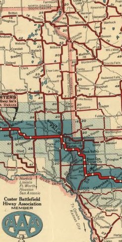
After eating lunch in Vermillion, we drove to Union Grove State Park and took a short walk in the forest. Today the temperature is about 50 degrees and the wind isn’t blowing, it’s much better than yesterday which was in the 30s with a strong wind. According to Lena’s travel log, the farm house where they were staying was about 11 miles south of Beresford, which places it in the vicinity of Union Grove State Park. The 1920 U. S. Census sheet that shows the record for the Fleege family gives us additional information about the road the Bevers family and Mr. McElhaney were traveling on. In the space for the street name, “King of Trails” is written. This is the transcontinental highway, shown on the 1925 Custer Battlefield Hiway map, that runs through Sioux Falls and Sioux City. Another thing the census sheet notes is the name of the township: Emmet. Unfortunately, the directions in the 1917 Blue Book don’t give enough information to positively identify which farm road was once the King of Trails Highway. Therefore, we were only able to get in the vicinity of the farm house.
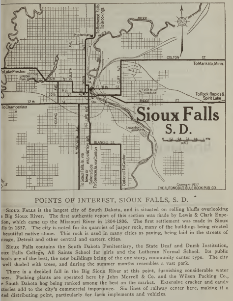
From The Official Automobile Blue Book 1917.5
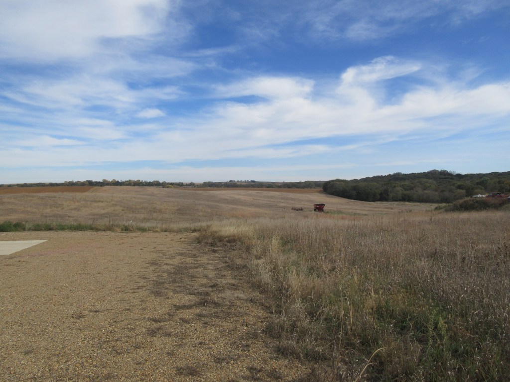
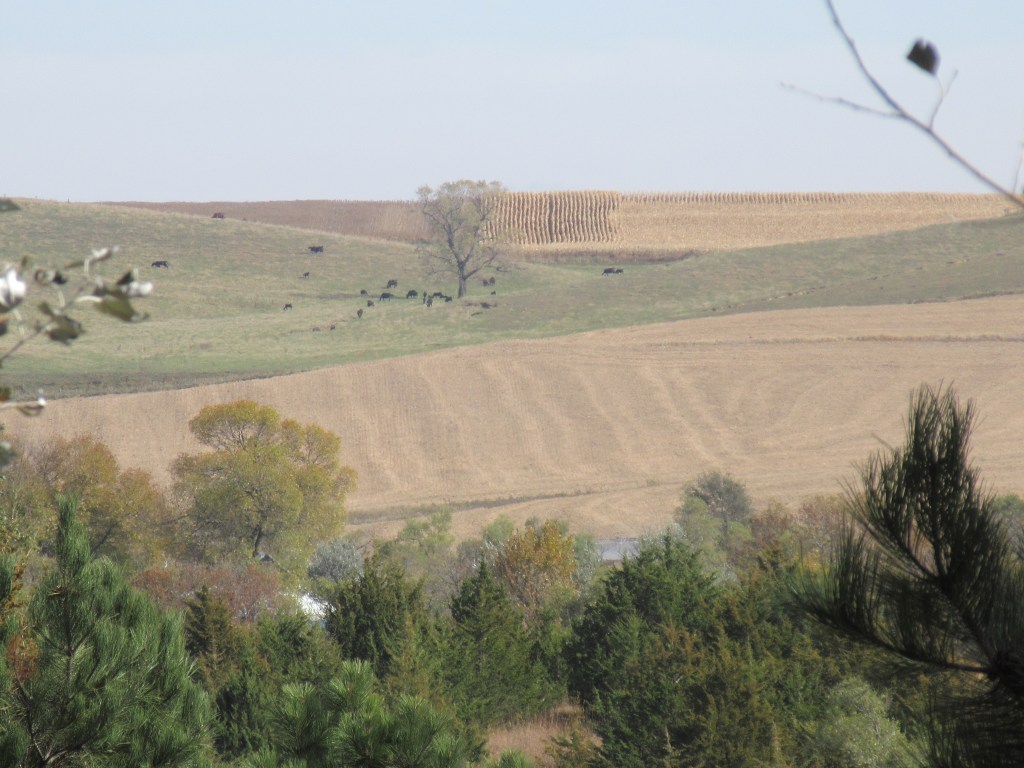
Farm land in Emmet Township, 11 miles south of Beresford (photos by MRW October 16, 2019)
Notes:
B. Winkelmann, Our Trip to Texas
[Transcription of Our Trip to Texas by Florence Bevers, 1919]
(unpublished, n. d.): 1.
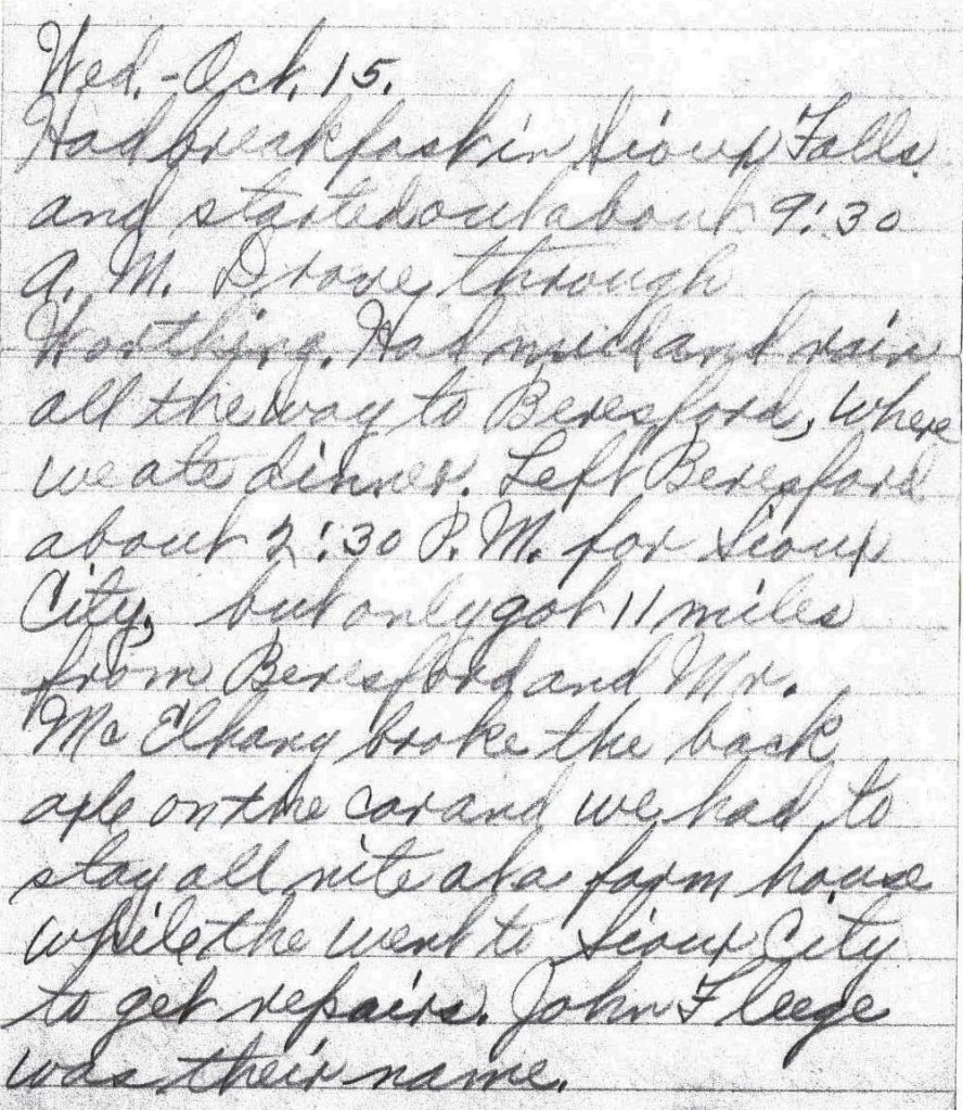
Had breakfast in Sioux Falls and started out about 9:30 A. M. Drove through Worthing. Had mud and rain all the way to Beresford, where we ate dinner. Left Beresford about 2:30 P. M. for Sioux City, but only got 11 miles from Beresford and Mr. McElhany broke the back axle on the car and we had to stay all nite at a farm house while [they] went to Sioux City to get repairs. John Fleege was their name. – Lena Bevers
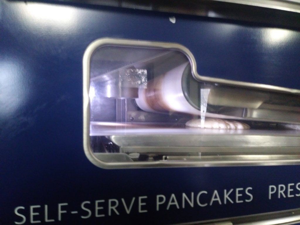
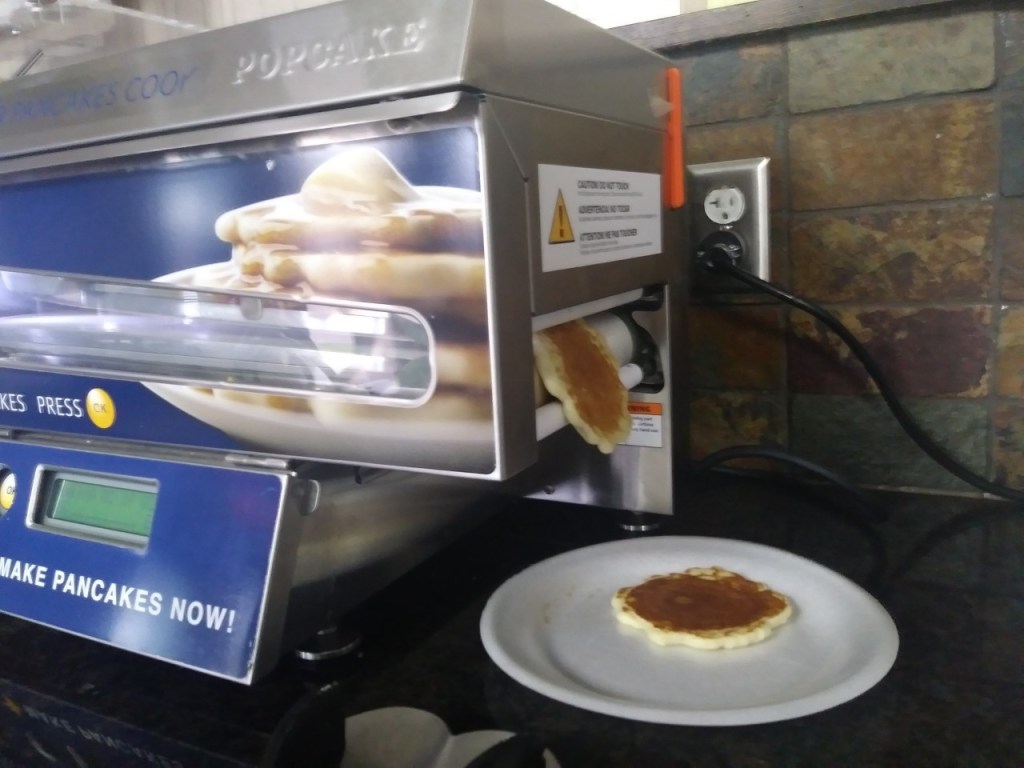
Lena begins this day’s log entry by saying they had breakfast in Sioux Falls. My mother and I stayed the night at a motel in Sioux Falls that provided a large selection of breakfast items. On the counter, I saw a machine that I had never seen before. It was a self-serve pancake machine, so I decided to see how the machine works. After dropping pancake batter on a conveyor belt, the uncooked pancake slides through two heated panels, one above and one underneath. In one minute, the pancake is cooked on both sides and slips out of the side of the machine. It’s fun to watch and the pancakes were delicious.
A few days ago, I received an email from my bank, saying that they needed me to submit a document. While in Watertown, because I didn’t want to access my online bank account using a public Wi-Fi connection, I had downloaded the document from my online bank account using our cousin’s computer, saving it to a USB drive. Our motel has a computer and printer available to its guests, so I printed the document yesterday afternoon. This morning I spent about 20 minutes on the phone with the bank (most of the time on hold), discussing exactly how they wanted me to fill out the form. Having accomplished that, we located a shipping company where I could fax the document to the bank. I relate all of this to record some of the ways I handle communication and banking while traveling – ways that are different from Lena and Herbert’s experience.
Before departing our motel this morning, we had a visit in the motel lobby with a cousin who lives in Sioux Falls. Then we prepared to leave. Herbert and Lena only traveled about 40 miles on their third day, so we waited at the motel until nearly check-out time at 11:00 AM.
Referring again to the 1925 Touring Map of the Custer Battlefield Hiway, there is a highway with the number 20 that heads directly south out of Sioux Falls.1 This number does not indicate a highway number, it is a reference to the numbering system in the map legend. On a 1919 automobile route map of Iowa, this same route is given the number 105 to coincide with that map’s legend.2 This route is the King of Trails highway, which is another transcontinental highway. Its northern terminal point is Winnipeg, Manitoba (the same as the Meridian Highway), which in the early nineteen hundreds was the third largest city in Canada and a major agricultural and railway center.3 The southern terminals are Galveston, Texas (also the same as the Meridian Highway) and Brownsville, Texas. So, running through the central plains of the United States, these two transcontinental highways were parallel.
When Lena and Herbert were traveling to Texas, the roads were not yet numbered by the federal, state or county governments. Routes were determined initially by local automobile organizations, then later as automobile tourists began taking longer excursions, the routes were established by coalitions of associations or individuals of many localities.
In 1917 the King of Trails Association was
organized. An article in The Parsons
Daily Sun describes the association as follows:
“It
is a nation wide civic organization with a membership embracing big public
spirited men from every walk of life — bankers, merchants, automobile dealers,
etc.
“The primary object of this institution has been the promotion of good roads and the general welfare of the communities through which the Highway passes.”4
One of the responsibilities of the King of
Trails Association was the marking of the route. The organization proudly announced its
accomplishment:
“The King of Trails is one of the best and most consistently marked highways in existence, there being on the entire route upwards of 14,000 painted poles that guide the stranger in a strange land. This year’s program calls for the remarking of the trail wherever necessary and the erection of danger signs at every grade crossing and other dangerous points on the entire highway. Particular attention will be paid to the marking of the highway through towns and cities.”5
King of Trails Pole Marker as re-created on the website of Bike Allen County (Kansas)
My
mother and I have several resources to help us decide our route each day: sheet
maps, electronic maps, navigational devices.
How did Herbert determine where to drive?
“With
the increasing popularity of automobile touring came a pressing need for
navigational aids, because during the early 1900s, geographic route-finding
knowledge was primarily local. People knew how to navigate on foot or by horse
and buggy within their local town or county using the mental map that they had
acquired through experience. Because people relied on mental maps, road signs
were not needed; thus signage was rarely a feature in the landscape. If someone
wanted to travel farther than a day’s carriage ride, he or she usually did so
by railroad. There was no need, for instance, to know how to navigate from
Chicago to St. Louis because the train did all the navigating and ‘driving.’
However, a locally based mental map was insufficient for navigating by
automobile. There were no road maps and few road signs, so how would someone
know which roads to take? In which direction would one travel? Where would one
turn?
“This problem of navigation, or finding one’s way, by automobile during the early years of the last century prompted entrepreneurial automobilists to create route guides. These guides helped early automobile tourists navigate through unfamiliar territory by collecting localized directional information and presenting it in a form usable to outsiders. Automobile clubs, highway associations, and other related organizations published or sponsored route guides during these years….”6
The Official Automobile Blue Book which used the tag line ‘Standard Road Guide of America,’ was the most popular set of touring books in the early 1900s. It provided drivers with written directions to travel between cities and towns at a time when roads were not yet designated with highway numbers and road signs. Sets of these touring books began to be published in 1901 with the purpose “to promote touring by establishing routes that connected automobile ‘supply stations.’”7
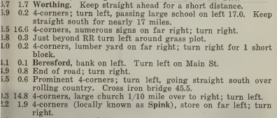
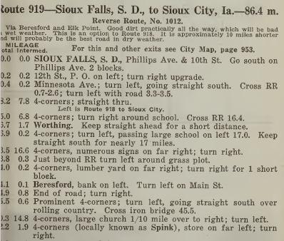
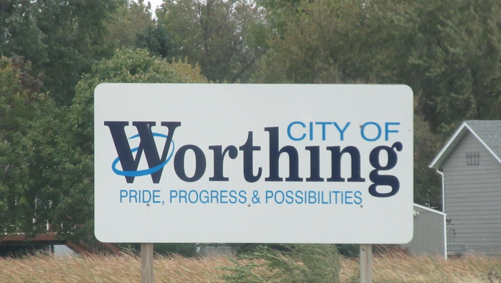
By 1917 there were 10 volumes in the set of The Official Automobile Blue Book. I was able to locate volume 5 of the 1917 edition on the Internet Archive website. It is not known whether Herbert and Lena had a tour book to follow, but as we attempt to retrace their route to Texas, we will be referring to this tour book. Route 919 in volume 5 has route directions from Sioux Falls to Sioux City. The book describes the route as: “Good dirt practically all the way, will be bad in wet weather. This is an option to Route 918. It is approximately 10 miles shorter and will probably be the best road in dry weather.”8 Unfortunately, Lena and Herbert did not have dry weather the day they left Sioux Falls. Lena recounts that they drove through “mud and rain all the way to Beresford,” driving through Worthing along the way.
The Blue Book directions above say to exit Sioux Falls on Minnesota Avenue (Highway 115), which is the road my mother and I started out on today. Just a few miles down the road Highway 115 had a detour, taking us to Interstate Highway 29. We did not want to take an interstate highway, so we took Louise Avenue (Highway 117) instead. It took us directly south to Worthing and also took us to Beresford.
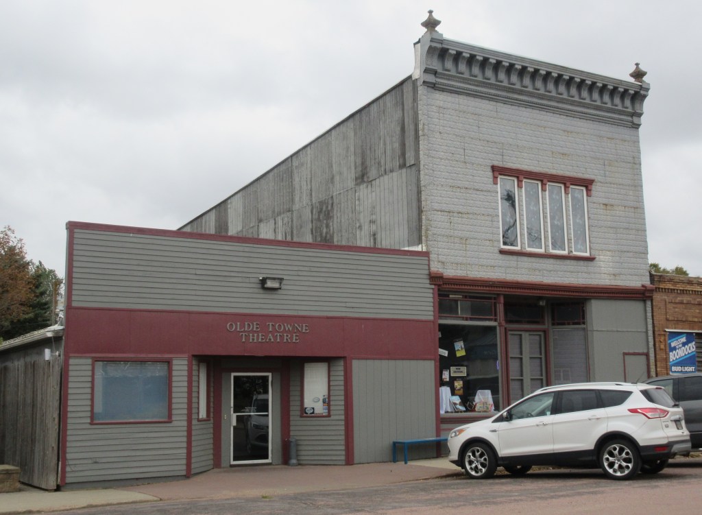
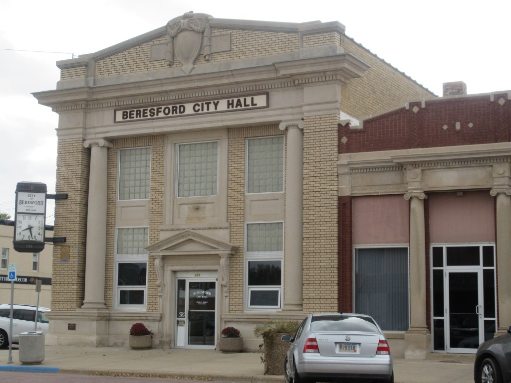
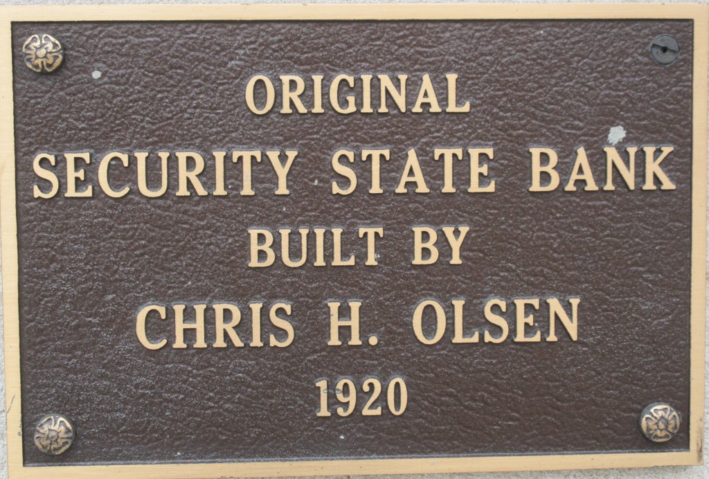
The Beresford City Hall used to be Security State Bank of Beresford, which was very likely under construction when Lena and Herbert’s family ate their mid-day dinner in Beresford. The cost of building the bank was $75,000, which made it one of the more expensive bank buildings at the time.9
At the rear of the Beresford Public Library you can see the old brickwork. This building was in existence when the Bevers family was in Beresford. It was a farm implement store.10 The front and inside were remodeled by the city about 1992 to hold the current library.
After dinner, the traveling party headed south, planning to make it to Sioux City, but about 11 miles south of Beresford, an axle broke on Mr. McElhany’s car. Lena and her children “had to stay all night at a farm house while the men went to Sioux City to get repairs.” Lena’s daughter reports in her travel log that the men “could not get the right axle.”11 My mother and I started down Highway 117, but only a couple miles down the road, it turned to a gravel road and we decided not to continue on that route. The Bevers Family stayed at the farm house of John Fleege. Instead of finding a farmer to take us in, we are staying at a motel in Beresford. We checked-in at 2:00 PM.
Notes:
John C. Mulford and C. C. Faunce, Touring map of the Custer Battlefield Hiway: the scenic route to the west. [S.l, 1925] Map. https://www.loc.gov/item/99466708/.
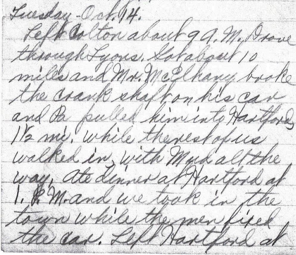
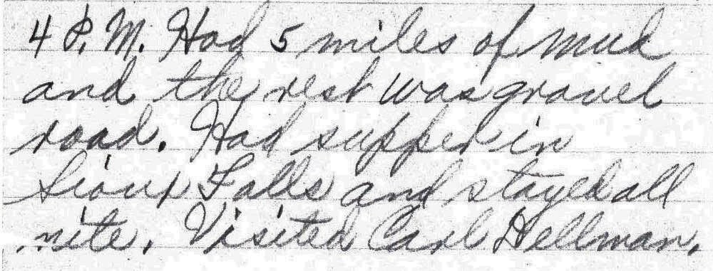
Left Colton about 9 A. M. Drove through Lyons. Got about 10 miles and Mr. McElhany broke the crank shaft on his car and Pa pulled him into Hartford, 1 1/2 mi. while the rest of us walked in, with Mud all the way, Ate dinner at Hartford at 1. P. M. and we took in the town while the men fixed the car. Left Hartford at 4 P. M. Had 5 miles of mud and the rest was gravel road. Had supper in Sioux Falls and stayed all nite. Visited Carl Dellman. – Lena Bevers
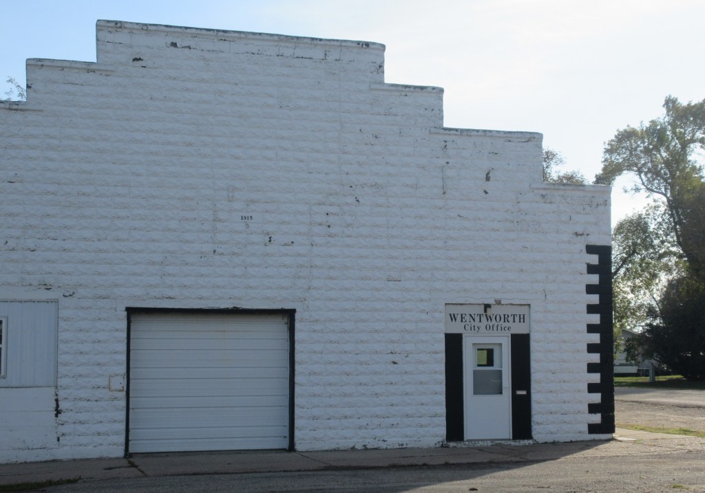
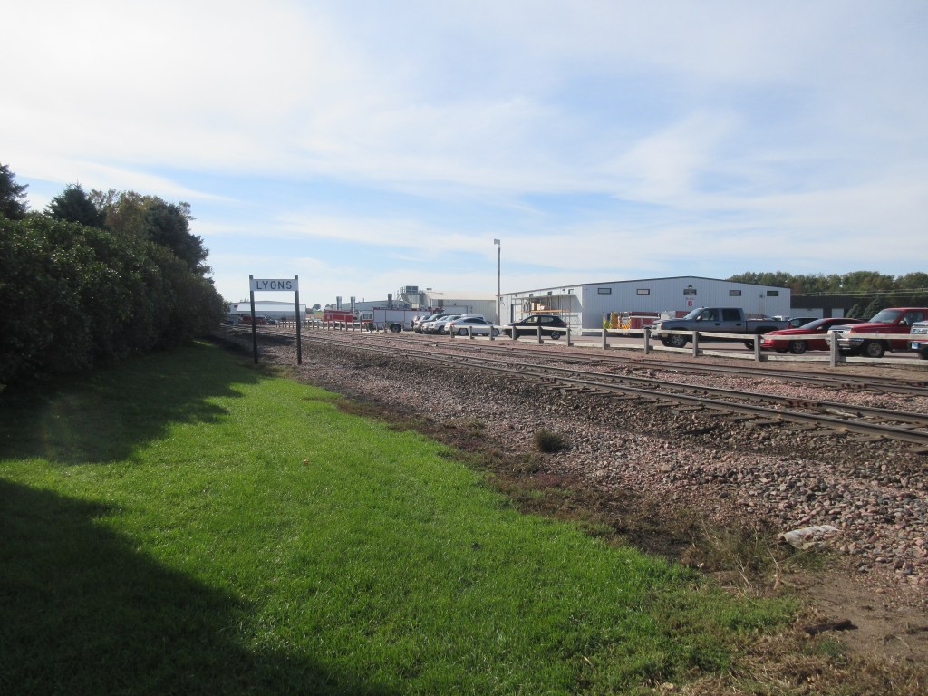
On the 1925 Custer Battlefield map which we began following yesterday, the Meridian Highway turns west at Madison and then south towards Yankton, South Dakota and Lincoln, Nebraska. Herbert and Lena did not follow that route, instead they headed for Sioux Falls using roads that are not marked on the Custer Battlefield map. Just two weeks ago, my mother learned that Herbert and Lena’s daughter Florence wrote a travel log also. It is very similar to Lena’s log, but it does give additional details. Florence recorded that they went through Wentworth on their way to Colton.1 When we left Madison today at 10:00 AM, we took county roads to Wentworth, Colton, Lyons and Hartford. All were macadam roads and the snow had melted so the driving was fine.
Wentworth is about half the size of Arlington and didn’t
take much time to drive around in it.
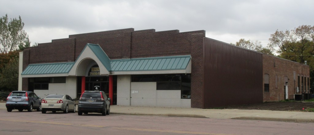
Colton was larger and seemed to be a center of business for
farmers. Lyons was smaller than
Wentworth and just seemed to be a stop for a railroad. All three of these towns were beside the same
railroad track.
The Wentworth City Office (Photograph by MRW October 14, 2019)
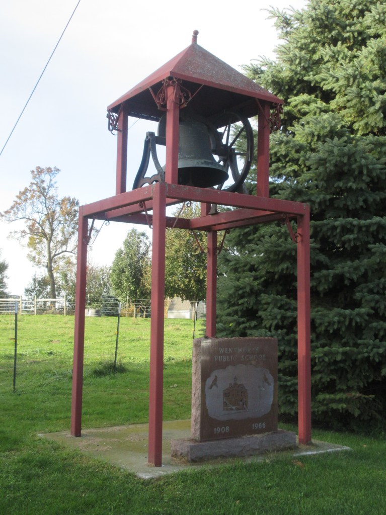
A bell from the Wentworth Public School that was built in 1908 (Photograph by MRW October 14, 2019)
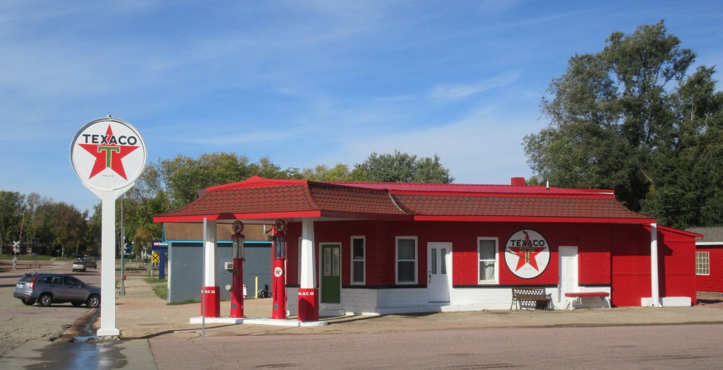
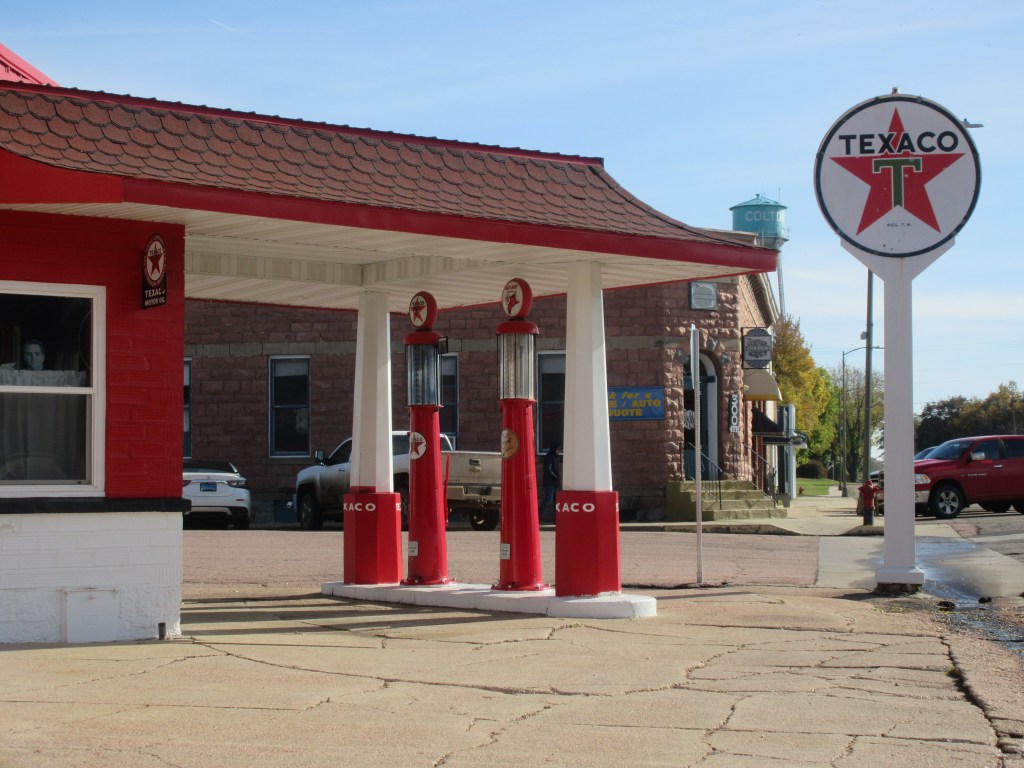
Although this service station may not be 100 years old and therefore may not have been standing in Colton when Herbert and Lena passed through …
… if these gas pumps are authentic, they are probably between 90 and 110 years old.2
In Lena’s travel log, this is the first of many days on which she mentions Mr. McElhany. She always uses the name, Mr. McElhany. So, who is Mr. McElhany? I have uncovered a couple possibilities. In The First 100 Years in Codington County, South Dakota, 1879 – 1979 there is a biographical article entitled, “Robert Mc Elhany Family”. The article says the following about two of Robert McElhany’s sons:
“Robert
never married and homesteaded southwest of Florence. He lived in Watertown some of the time and
moved to Texas in 1918.
“Clarence
married Myrtle St. Clair. They had no
children. They lived on a farm near his
brothers until he moved to Texas in 1918.”3
Perhaps one of these men is the driver Lena
calls Mr. McElhany. If so, the date of
his move to Texas would actually have been 1919 instead of 1918 as recorded in
the article.
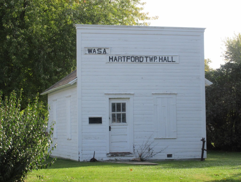
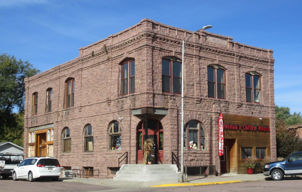
About 10 miles after passing through Lyons, Mr. McElhany broke the crankshaft of his car and had to be pulled one and a half miles into Hartford by “Pa” (Herbert). Lena wrote that “the rest of us walked in, with mud all the way” — that would have been herself and six of her ten children: five-year-old Margaret, seven-year-old Harold, 10-year-old Estella, 12-year-old Hazel, 14-year-old Helen and 16-year-old Florence. According to one of Lena’s grandsons, it did not include Willis who was 18 years-old, because he was traveling to Texas on a train with the family’s cattle and horses.4 And according to another grandson of Lena, it also did not include Arthur because he was also on the train with the livestock.5 (Arthur had married Gladys Daily just four months before his parents’ departure to Texas.) It also didn’t include Edgar because he was in the military and was not discharged until October 20th, a week after his parents left Watertown.6 Nor did it include Clarence, he had married in 1917 and was listed in the Watertown City Directory for 1919-1920, working as a repairman at Auto Radiator Service Co.7 (It is not known if Mr. McElhany had any passengers with him.)
My mother and I traveled to Hartford on asphalt county roads. Upon arriving there, we found that over the last several decades the residential district has expanded about a mile from the center of town. The population is now about 2,500. After driving through the old business district, we found a city park where we ate our picnic lunch. Then we took Highway 38 toward Sioux Falls.
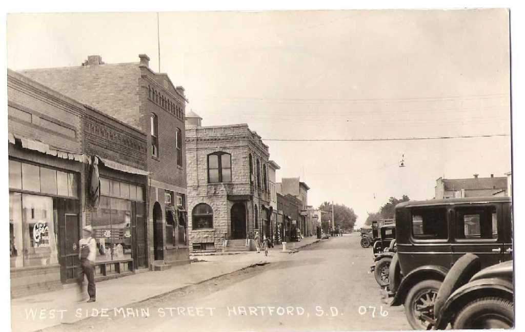
West Side Main Street, Hartford, South Dakota (Courtesy of the City of Hartford)8
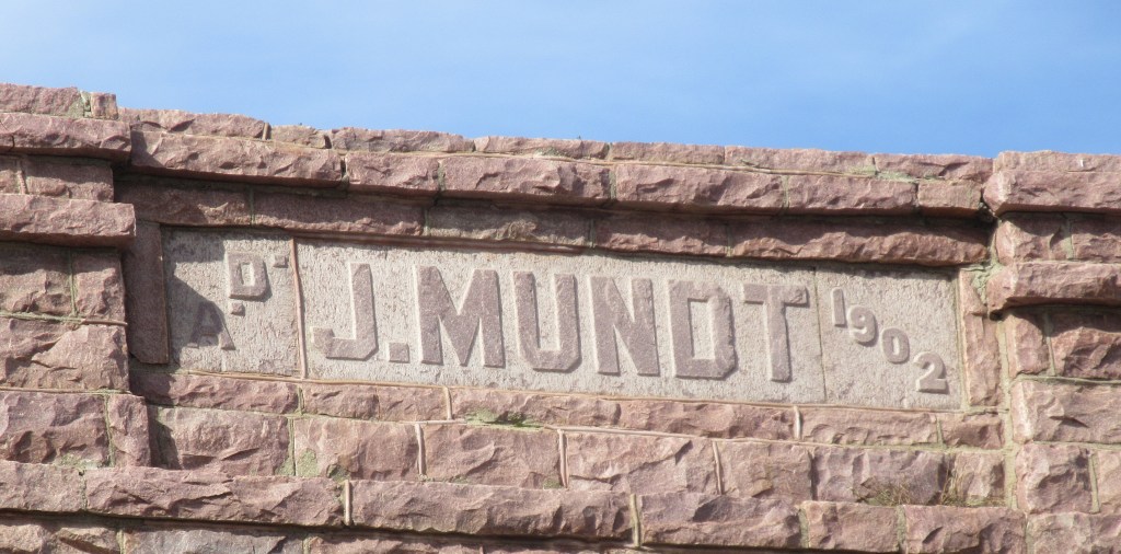
The date on this building is 1902, so it was standing here when Herbert and Lena were here.
After Mr. McElhany’s car was fixed in Hartford, they headed down muddy roads and gravel roads until they reached the city of Sioux Falls. The last thing Lena notes for this day is that they visited Carl Dellman. Carl was the son of Lena’s cousin Kate (Katherine Huppler Dellman). When the 1920 U. S. Census was taken on January 5th (2 1/2 months after Lena’s family visited him), Carl was living at 1428 Main Avenue in Sioux Falls, he was married to Amber L. Best and had three daughters, ages 6, 4 and 2 1/2, and he was the proprietor of a radiator shop.9 He apparently had not been living in Sioux Falls very long, because the 1919 Watertown City Directory has a listing for him, living in Watertown and he was one of three owners of Auto Radiator Service Co.10 This is the same auto repair shop where Lena’s son Clarence was working.
The census taker who visited Carl also visited a neighborhood “N. E. of the penitentiary.” Referring to a map of Sioux Falls published in 1917 in the Official Automobile Blue Book, I have concluded that his home was on North Main Avenue rather than South Main Avenue.11
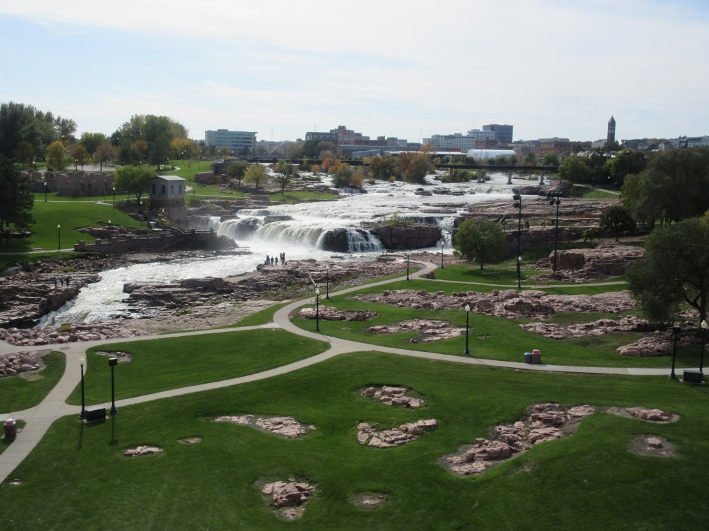
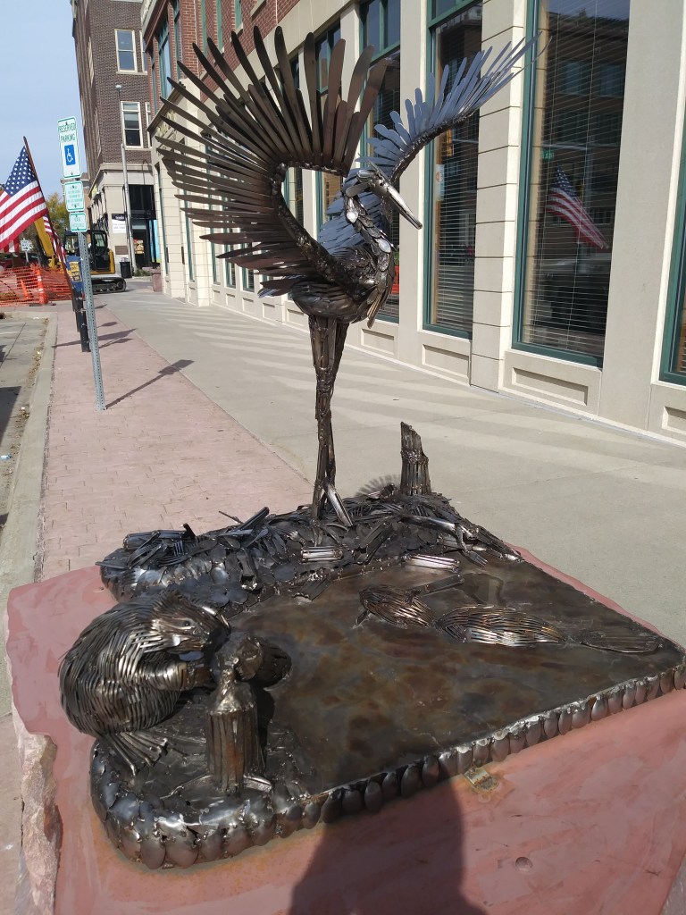
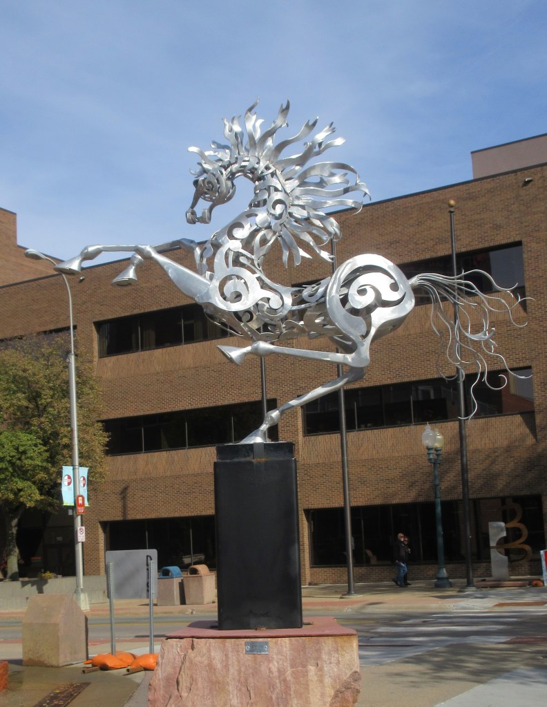
We arrived at the Dellman house about 1:00 PM, so we had all afternoon to take in some sights in Sioux Falls. Not far from the Dellman home is Falls Park, where we rode in an elevator to the top of a lookout tower to view the falls of the Big Sioux River. We also went downtown and walked along three blocks between 9th and 12th Streets, viewing numerous sculptures that are displayed on the sidewalks. After going through a car wash, we arrived at the motel at 3:30 PM.
Falls Park, Sioux Falls, South Dakota (Photographed by MRW October 14, 2019)
My mother’s favorite sculpture, titled “Under Construction”: beavers and heron made of knives, forks and spoons. (Photographed by EJJ October 14, 2019)
My favorite sculpture, titled Silver Belle (Photographed by MRW October 14, 2019)
Notes:
B. Winkelmann, Our Trip to Texas [Transcription of Our Trip to Texas by Florence Bevers, 1919] (unpublished, n. d.): 1.
“Robert Mc Elhany Family,” In The First 100 Years in Codington County, South Dakota, 1879-1979, by Codington County History Book Committee (Watertown, South Dakota: Watertown Public Opinion Print, 1979): 261.
D. L. Bevers, Herbert and Lena Bevers trip to Raymondville Texas [Transcription of Our Trip to Texas by Lena Bevers, 1919] (Unpublished, n.d.): 4.
C. M. Bevers, personal communication with M. R. Wilson (October 9, 2019).
Hill, Harry L., ed. 1919, Watertown City and Codington County Directory 1919-1920 (Watertown, South Dakota: Watertown Printing and Binding Co.): 33 & 64.
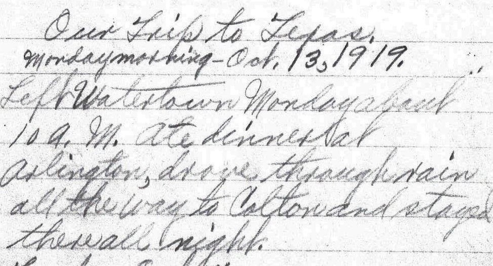
Left Watertown Monday about 10 A. M. Ate dinner at Arlington, drove through rain all the way to Colton and stayed there all night. – Lena Bevers
Today is Sunday, but 100 years ago October 13 was on a Monday, and about 10:00 AM that day Herbert and Lena Bevers, along with six of their children, began a trip from Watertown, in northeastern South Dakota to the southern Texas town of Raymondville, near the U. S. border with Mexico.
Lena kept a log of their travels and according to her entry, their first destination that day was Arlington, where they ate their mid-day meal (dinner). Arlington was about 40 miles south of Watertown, and their final destination for the day was Colton which was approximately 50 miles south of Arlington. At that time the law regarding driving speed in South Dakota was: “Careful and prudent, having regard to traffic conditions.”1 If we assume that they drove about 6 hours that day, then they were driving about 15 miles per hour.
For the next 27 days, my mother and I will attempt
to retrace Herbert and Lena’s route. For
the first few days, we are going to base our route on a map obtained from the
Library of Congress website (https://www.loc.gov/resource/g4126p.mf000065/). It is called the Touring Map of the Custer
Battlefield Hiway, dated 1925, and it was published by the National
Highways Association, which was incorporated in 1912 in Washington, D. C. Printed on the map is the following
statement, explaining the purpose of the association:
“A membership corporation which exists to favor, foster and further the development of NATIONAL HIGHWAYS and GOOD ROADS EVERYWHERE in the length and breadth of these United States of America, and to secure the benefits — social, moral, commercial, industrial, material, educational and personal — in the progress and uplift of the American people which follow in the train of easy intercommunication and transit between the great centers of population and distribution and the great rural productive areas of the Nation, and so ‘bind the States together in a common brotherhood, and thus perpetuate and preserve the Union.'”2
On this map there is a highway with the number 25 (this is not a highway number; it is simply the number associated with the numbering system of the map legend). In the legend this highway is named Meridian Highway. Meridian Highway was a transcontinental highway with starting and ending points of Winnipeg, Manitoba, Canada and Galveston, Texas and Mexico City. Running along the eastern border of North Dakota, this highway entered South Dakota, veered west a short ways, then headed south. Thirty miles north of Watertown, it crossed over the Yellowstone Trail, an east-west transcontinental highway which ran from Plymouth Rock, Massachusetts to Puget Sound, Washington.3 Meridian Highway continued south and passed through Watertown. Currently, from the northern border of North Dakota to Watertown, Interstate Highway 29 and U. S. Highway 81 roughly follow the route that was once called the Meridian Highway. At Watertown, U. S. Highway 81 breaks off from Interstate Highway 29, continuing to follow more closely the original Meridian Highway.
Section of Touring Map of the Custer Battlefield Hiway (Retrieved from Library of Congress, Geography and Map Division.)
Having had a blustery snow storm on Friday and Saturday, and fearing that we might have to delay our departure for a few hours, my mother checked the weather report on her phone at 6:30 AM this morning. The forecast said there’d be cloudy skies but no snow. The roads did not look icy as well, so my mother and I set out on schedule at 8:00 AM from Watertown on a macadam road. Our journey began on U. S. Highway 81, which presently runs straight south from Watertown to Madison, traveling between Lake Albert and Lake Poinsett, but on the 1925 map after starting south the Meridian Highway took several zigzag turns southwest toward Hayti and then resumed its southernly direction, circumventing Lake Albert on the west side. So, we needed to leave U. S. Highway 81, but we could not determine exactly which roads Herbert drove toward Hayti. We decided to take Highway 21 which took us through Hayti and Lake Norden. We ran into difficulty when we exited Lake Norden because the roads were not marked. A few miles further the road was snow-covered, so we decided to turn back and take a well-traveled route.
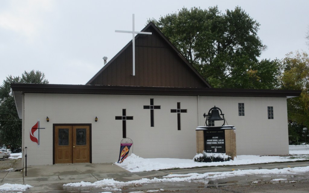
At mid-day Herbert and Lena would have reached a road numbered 7 on the Custer Battlefield map and named the Black and Yellow Trail. This route ran from Chicago to Yellowstone National Park. Here they turned east and drove to Arlington. If they had turned to the west, they would have driven toward De Smet, the town in which Herbert’s father and two sisters lived. Since we can travel more miles in a day than they could, we took a side trip to De Smet and attended the worship service of De Smet United Methodist Church, arriving 10 minutes late because we had to change our route.
De Smet United Methodist Church (photographed by MRW Oct. 13, 2019)De Smet Methodist Episcopal Church (photographed about the 1920s)
De Smet is the town made famous by Laura Ingalls Wilder in her book Little Town on the Prairie. Wilder’s parents homesteaded north of De Smet and came to the town for supplies. The Ingalls family lived in De Smet from 1889 until at least 19244, which overlaps with the time that Herbert’s father, mother and sisters lived in De Smet.
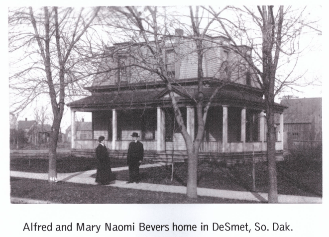
After the church service, the pastor allowed my mother and I to examine four of the church’s early record books. This research confirmed some facts already known and gave us new information about the lives of these ancestors. Alfred C. Bevers and his wife Mary lived their final years in De Smet, beginning in 1898, bringing their daughters Gertrude and Maude with them. An historical article states that Alfred was a retired minister and his family “brought a lot of encouragement to the church.”5 Mary and Gertrude were involved in the Ladies Aid Society. Gertrude and Maude were members of a young adult group called the Epworth League. Maude led the choir for many years. In 1904 Maude married Alfred N. Waters, a real estate agent in De Smet. Mary passed away in 1910. In 1920, a few months after Herbert and Lena traveled down Meridian Highway, Alfred at age 82, was renting a house on 2nd Street and his unmarried daughter Gertrude was living with him.6 Maude and her husband also lived on 2nd Street.
When we left the church, we started searching for the houses of the Bevers and Waters families. The 1920 census records of De Smet list the street name as 2nd street, but there are no street numbers. Although a couple homes seemed familiar to my mother (she had visited her great-aunts Maude and Gertrude as a child), we could not be positive that any of the homes were the ones in which the Bevers and Waters lived.
Then we headed for the De Smet Cemetery. When we were about a mile from the cemetery, the road became slushy so we did not travel any further. At that point we got on Highway 14, heading toward Arlington, the town where Lena and her family had dinner (their mid-day meal.)
Arlington is a town with a population of
915. Finding a place to eat lunch was a
challenge. We drove down the two blocks
of the main street and found only a bar/grill/bowling alley which was not open
on Sundays. Driving about half a mile
outside of town, we came to a restaurant that didn’t open until 4:30 PM on Sundays. Nearby was a gas station that advertised subs
and pizza in the window, but it also was closed. Then we saw a motel that had a diner, which
closed at 1:00 PM and we were there at 1:15 PM.
Finally, we were directed to another gas station/convenience store which
had a nice selection of sandwiches, burgers, chicken and wieners.
After lunch we took one more side trip to visit my mother’s brother-in-law in Brookings. When we returned to U. S. Highway 81 to resume following Herbert and Lena’s route, we found that the highway was closed and we would have to follow a detour which took us fifty miles out of our way.
At Madison, Herbert and Lena left the Meridian Highway and headed toward Colton where they ended their day. My mother and I wanted to stay the night in Colton, but when we searched online for a motel there, we couldn’t find one. So, we ended our day in Madison, arriving at the motel at 5:30 PM.
John C. Mulford and C. C Faunce, Touring map of the Custer Battlefield Hiway: the scenic route to the west, [S.l, 1925] Map. https://www.loc.gov/item/99466708/.
First Methodist Church, “A History of the Church,” Consecration Service of the Remodeled First Methodist Church (De Smet, South Dakota: First Methodist Church, September 26, 1965)
In the fall of 1919 Herbert and Lena Bevers moved their family from Watertown, South Dakota to Raymondville, Texas. It took 27 days to make the trip and each day Lena wrote a few sentences about their travels, such as the road conditions, the towns they traveled through, where they had dinner and where they stayed for the night.
Two years ago I realized that the one hundredth anniversary of Herbert and Lena’s trip was approaching. I began researching for the routes that they would have taken, and as I researched I gradually became aware that 1919 was in the midst of a very significant period of road development in the United States. Long distance travel by automobile was just becoming practical and advantageous for the general population.
Beginning on October 13, 2019, according to my best research efforts, my mother and I will drive the route Lena recorded in her log and each day I will post what I have learned about traveling in 1919 as well as what I learn about a few of the changes that have occurred in the century that has passed since Herbert and Lena made their trip to Texas. I hope that you will find the time period as interesting as I do.


