Reminiscences of Uncle Bob, Part Five

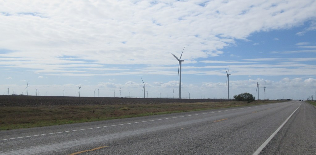
On the 10th of April, 1915, Charles and Maggie Daily left Omaha and headed with their family to South Dakota because Maggie “wanted to get back to the farm” (according to their son Robert1), and possibly wanting to get away from the tornadoes (according to one of their grandsons2). They moved to a farm in Rauville Township in Codington County.3  Rauville was “a station on the [Great Northern Railway], 6 miles N of Watertown,” and primarily the site of two grain companies.4 

The Daily family had been in South Dakota for two months when the state census was taken.  At that time, Charles was 58 years-old, Maggie was 47, Gladys was 22, Oranna, 19, Robert, 15, Iona, 12 and Elizabeth, 10.  The census forms of Charles and Maggie reveal that they had received a common education and the forms of Gladys and Oranna indicate that they had attended high school.  Also, the forms of Maggie, Gladys, Oranna and Robert note that their church affiliation was Methodist.


At about the age of 84, during an interview, Robert explained a little about settling in Rauville Township:

Interviewer:  When you came up here then [South Dakota], you prob’ly had a quarter to start with.

Uncle Bob:  Yeah, a quarter up here.  Across from Rauville Hall.

Interviewer:  Okay.

Uncle Bob:  Rauville Hall out there, eight miles north [of Watertown].

Interviewer:  And then you moved a mile south.

Uncle Bob:  Yeah, a mile south.  ‘Course, then we had the three quarters.

Interviewer:  And then didn’t you live further, uh, to the northwest of there?

Uncle Bob:  Ahh, not northwest.  But we come on down in ’29.  See Dad was on that place from 1917.  When we lived on the [Brent? or Brandt?] farm two years –

Interviewer:  Okay.

Uncle Bob:  ’15 and ’16.  Come down to Gunther’s in the fall of ’16.

Interviewer:  Um hmm.

Uncle Bob:  And o’ course, an’ then we lived there.  We lived there for 13 years, up to ’29.

Interviewer:  Oh!  You lived there quite a while.5


Charles’ name was in the Farmers’ List of the 1916 Watertown City and Codington County Directory, which indicated that he was a farm tenant of a 160-acre farm in section SW 17 of Rauville Township.6 In the 1919 edition of the directory, the entry for Charles noted that he was renting in section NE 30 of Rauville.7

Another thing Uncle Bob related was that in 1917 Charles’ brother William visited them while they were living at the Gunther farm and that was the last time that they saw William.  (He passed away in 1925 in or near Lovelock, Nevada.) Uncle Bob expounded, “I know he, when he went back through Chicago, why he, uh, bought a watch, a Waltham watch, for Dad. Sent it to him.  An’ Dad wore it, oh, clear up ‘til he was gone.  An’ I had it an’ I give it to [my son] for — to take care of, see.  Well, it’s in’resting, it’s right here in Watertown, it’s in [my son’s] lockbox right here in Watertown.”8  This would have been about 65 years after the purchase of the watch.

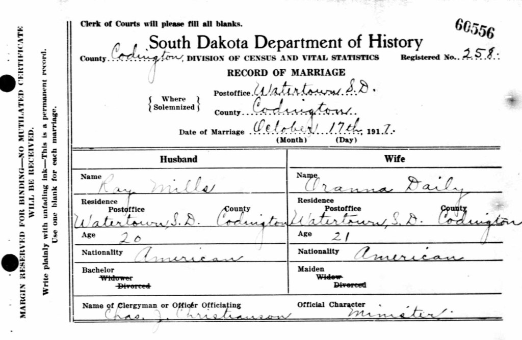
During the next several years, one by one Charles and Maggie’s children began moving out of their home, either by marrying or by finding work in a different location or by moving to Watertown to go to high school.  On October 17, 1917, 21 year-old Oranna married 20 year-old G. Ray Mills.  They were married by Charles J. Christianson, the pastor of First Congregational Church, which was located in Watertown.9  The following year, Oranna gave birth to Charles and Maggie’s first grandchild.  By 1919, Ray had begun farming near Rauville.10

Marriage record of G. Ray Mills and Oranna J. Daily, October 17, 19179

Newspaper items in the Watertown Public Opinion reveal that the Daily family became friends with the Herbert J. Bevers family.  On October 11, 1917, the newspaper reported: “Mr. and Mrs. Herbert Bevers, family and Miss Strombotne were dinner guests at the C. M. Daley [sp.] residence, near Rauville, Sunday.”11  The same issue also stated, “The Bever [sp.] and Daley [sp.] families autoed to Hazel and Grover Thursday on a combined business and pleasure trip.”12  On March 14, 1918, it was reported that “The Herbert Bevers family had as their guests, Sunday, Mr. and Mrs. Raymond Mills, Robert Dailey [sp.] and the Misses Iona and Elizabeth Dailey [sp.], of Rauville, and Miss Verna Edwards of Hazel.”13  Later that year, on July 11, a short article recounted that “Mr. and Mrs. H. J. Bevers of Elmira township, accompanied by Messrs Dailey [sp.] of Rauville and Wells of [Watertown], returned last week from a trip through portions of Minnesota and North Dakota. … [In the] valley of the Red River…, north of Big Stone City, S. D. … ‘it impressed [them] as having crops enough to feed the world, judging by the looks of the fields of grain.’”14


The First World War had broken out in Europe in 1914 and the United States entered the war in April 1917.  In June of that year the U. S. Congress authorized President Woodrow Wilson to institute a military draft of men from the age of 21 to 30.15  The purpose of this Selective Service Act was to increase the size of the army to 500,000 men.  A year later the army still was not large enough, so in August 1918, the Selective Service Act was amended to include all men between 18 and 45.16  Uncle Bob who turned 18 years old in May 1918 registered for the draft in September of that year.17  Mercifully, the war came to an end in November 1918 and Uncle Bob never served in the military.18 By 1920 Uncle Bob was boarding in Watertown at the home of Harold and Lula Nordaker, and working for a transfer company as a drayman (a driver of a cart or vehicle without fixed sides).19

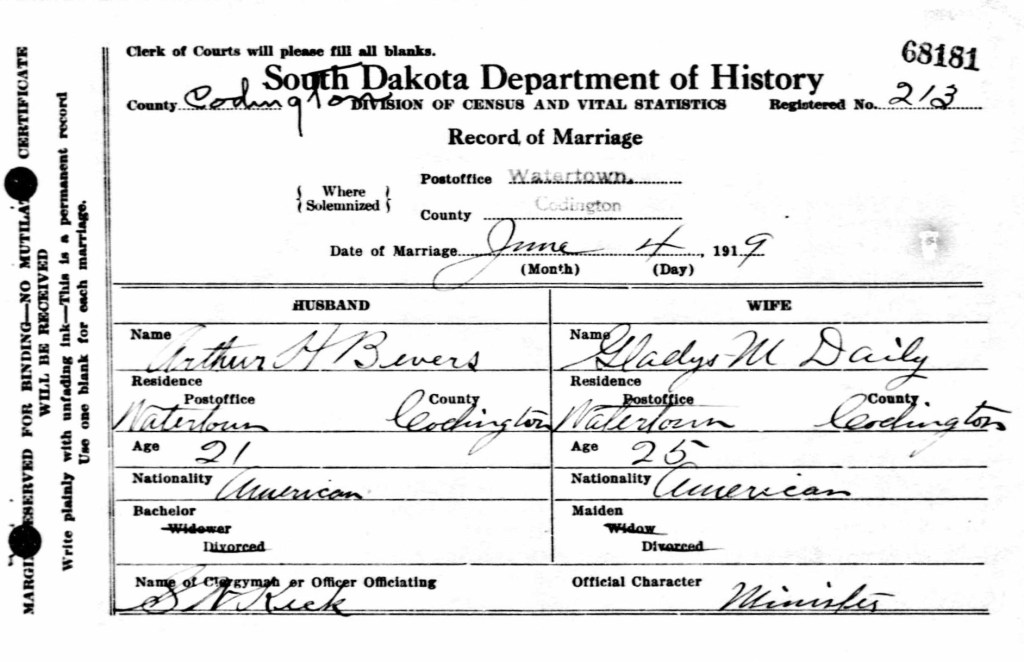
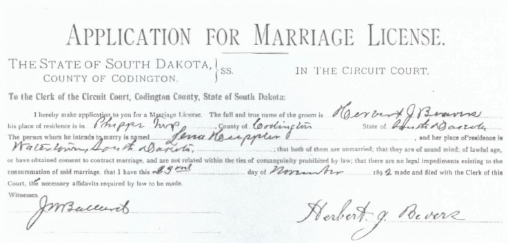
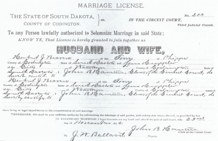
The Daily family and the Bevers family became linked in 1919 when 25 year-old Gladys married 21 year-old Arthur on June 4th.  The marriage was officiated by S. W. Keck, the pastor of First Congregational Church.20  On February 18, 1920, when the U. S. census was taken, Arthur and Gladys were living with Charles and Maggie on the farm in Rauville.21  Two months later, Arthur and Gladys’ first son was born on that farm,22 giving Charles and Maggie a second grandchild.  Iona and Elizabeth were also recorded on the 1920 census sheet.

Marriage record of Arthur H. Bevers and Gladys M. Daily, June 4, 191920

In the 1919 Watertown directory, Iona was identified as a student and she was boarding at 215 4th Street SW, which was the address of George and Hattie Baxter.23  At the age of 17, she was attending Watertown High School.  Iona graduated in May 1921 and three months later, after obtaining a South Dakota Second Grade Teacher’s Certificate, she entered into a two-year contract with Richland School District No. Six and began teaching on September 5th.24 Elizabeth would also attend Watertown High School, graduating in 1923 at the age of 18.


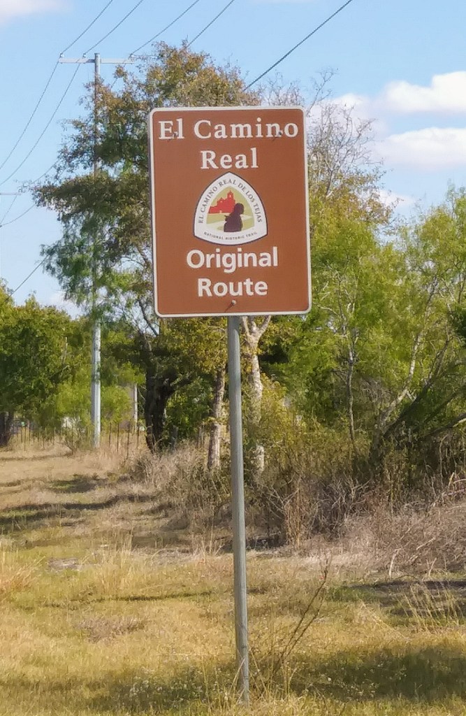
The 1920 U. S. census indicated that the farm that the Dailys were renting was on Meridian Road, also known as Meridian Highway.  In 1911, a road development association, the International Meridian Road Association, had organized for the purpose of building a transcontinental road, on which “a full wagon-box load or a car at high gear can pass, except in wet weather.”25  The name of the highway was “derived from the Sixth Principal Meridian, which extends north-south through the Great Plains region.”26 The route that was designated as the Meridian Road had a starting point in Winnipeg, Manitoba, Canada and ending points in Galveston, Texas and Mexico City.  Traveling along the eastern border of North Dakota, this highway entered South Dakota, veered west a short ways, then headed south and passed through Rauville and Watertown.  Presently, from the northern border of North Dakota to Watertown, Interstate Highway 29 and U. S. Highway 81 roughly follow the route that was once called the Meridian Highway.

The Meridian Highway evolved primarily as a farm-to-market road, important to the rural areas, small towns, and cities through which it passed.  The original route followed section line roads, running perpendicular to historic east–west transportation corridors.  Reflecting its creation from existing farm-to-market rural roads, the original highway passed through each county seat along its route.  In 1911 the Meridian Road Association was formed to mark, map, and promote the highway; in 1919 it became the Meridian Highway Association.  Similar to contemporaneous good roads organizations, the Meridian Highway Association consisted of representatives from the states, counties, and cities along the route.  The Meridian Highway promoters, however, perhaps in recognition of its divergence from more established routes, emphasized the absence of mountain passes and proclaimed that motorists could travel from Canada to Mexico without shifting gears.  The association sold memberships and instituted widely publicized tours.  When the association was a year old, in 1912, an automobile caravan was organized to travel the route south to Mexico, an event that was irregularly repeated in subsequent years.27


According to the U. S. census of Omaha, in 1920 Maggie’s mother Josephine (nee Smith) Bonewitz was living with Maggie’s niece Maggie (nee Thompson) Stier.28  Maggie Stier and her husband Fred were renting one of the two homes that the Dailys still owned in Omaha.29  In his interview, Uncle Bob mentioned a trip that Maggie Daily made to visit her 83 year-old mother in Omaha:

Uncle Bob: October 7, 1920. Yeah, that’s right there. I can remember that, oh, [like] it was yesterday. Mother was — Mother went down to, uh. ‘Course, I had a date with Ruby and Mother was away, at the time, see.

Interviewer:  Um hmm.

Uncle Bob:  An’ ‘course, Grandma passed away.  I don’t know what this date was, far as it was in 1920.  An’ she come home on the train an’ I was suppose t’ meet her.  An’ I didn’t. 

Interviewer:  And you didn’t.  [squealing laughter]

Uncle Bob:  I didn’t [pass] that too well.

Interviewer:  And you were in trouble!

Uncle Bob:  Yeah.  Didn’t think much of me.  [chuckling]30


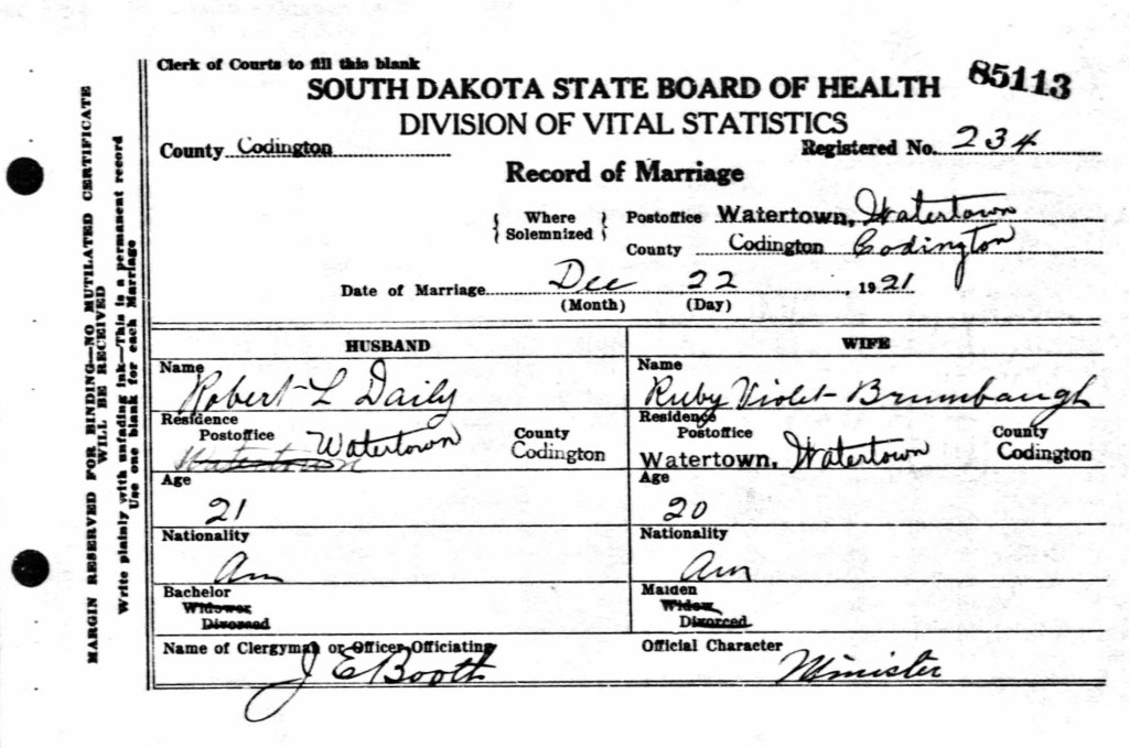
Just over a year later, Robert married Ruby Brumbaugh on December 22, 1921.31  The following December, Ruby gave birth to Charles and Maggie’s fourth grandchild.  Gladys had had her second child in August 1921 (the third grandchild) and Oranna would have her second child eight days after Ruby (the fifth grandchild).

Marriage record of Robert L. Daily and Ruby V. Brumbaugh, December 22, 192131

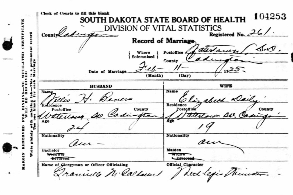
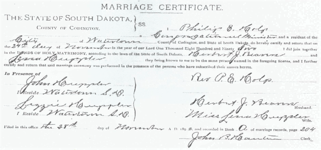
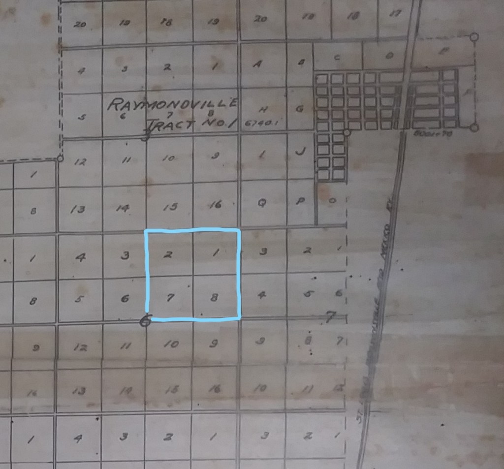
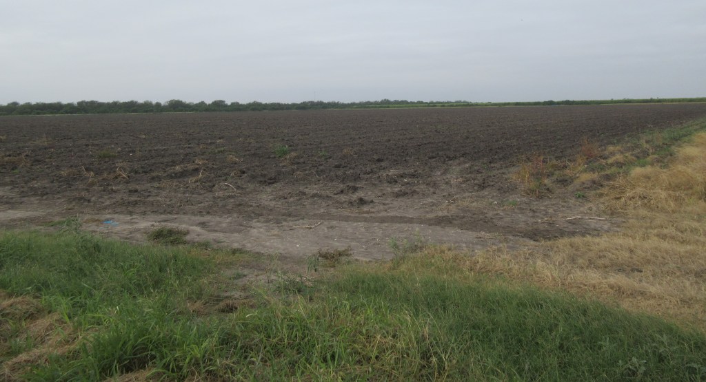
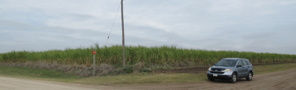
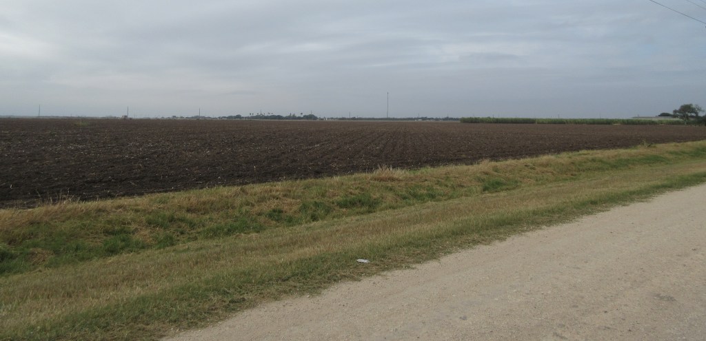
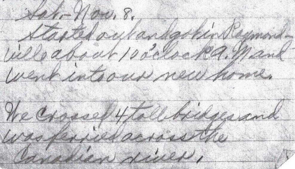
When Gladys’ in-laws, Herbert and Lena Bevers, moved their family to Raymondville, Texas in the fall of 1919, Elizabeth and Iona kept in touch with their son Willis.  The Bevers family returned to South Dakota a year later, but Willis stayed and worked on a road crew for another year.32  About three years after Willis returned to South Dakota, Elizabeth and Willis would marry.  The letters that they had exchanged during those two years are in the possession of one of their sons.  They were married on February 11, 1925, by Granville M. Calhoun, the minister of the Methodist Episcopal Church in Watertown.33 They set up their household in Watertown for a few months and later moved to a farm southwest of Grover.34 Their first child was born in December 1925 and was the tenth grandchild of Charles and Maggie.  Gladys had born two more children, and Oranna and Ruby had each born one more by this time.

Marriage record of Willis H. Bevers and Elizabeth J. B. V. Daily, February 11, 192533

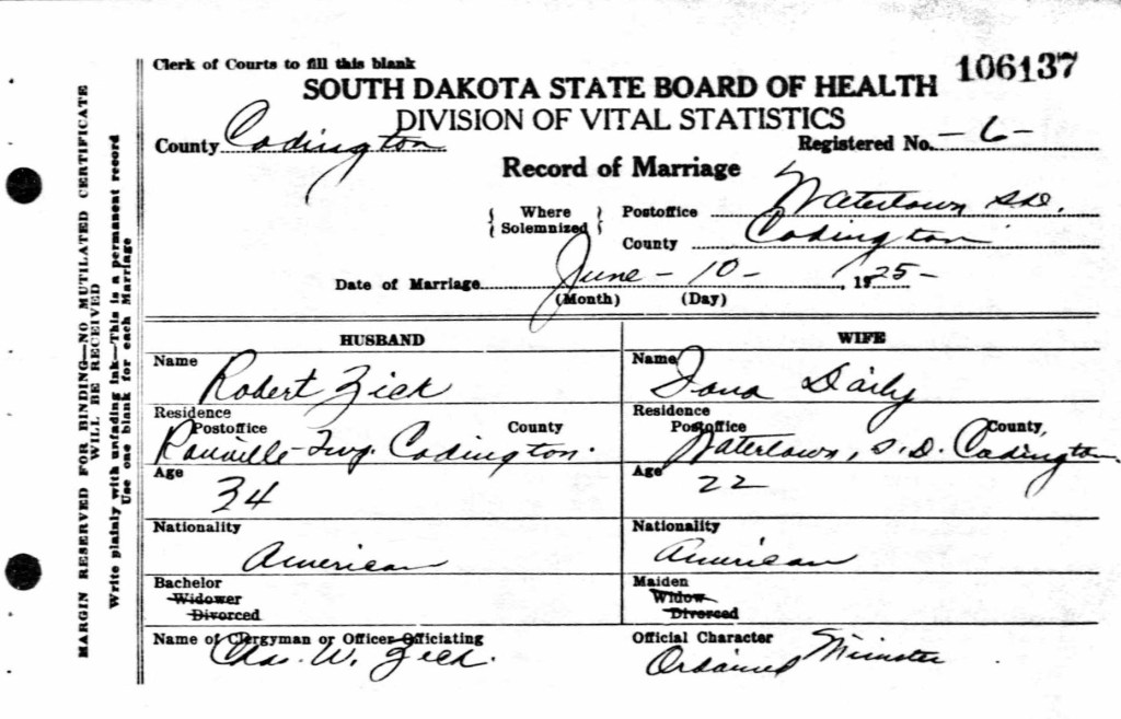
When the 1925 South Dakota Census was conducted, the only child that was living with Charles and Maggie in Rauville was 22 year-old Iona.  She would get married soon afterward, marrying Robert Zick on June 10.35  The officiating minister was Charles W. Zech [sp.?], who was likely the pastor of First Church Evangelical Association.36  Charles and Maggie’s daughter Gladys and her family were living in Rauville, but they may have been living on a different farm than Charles and Maggie.  Oranna and her husband were also still in Rauville.37  Robert had moved with his family to a farm in Germantown Township, Codington County.38


Marriage record of Robert Zick and L. Iona Daily, June 10, 192535

After living and working for 13 years on the Gunther farm, Charles and Maggie moved to another farm in the fall of 1929.  Uncle Bob explained the circumstances around their move:

Uncle Bob:  So, I went out there in the spring of ’29 on [Longstocker?] place.  An’ then Dad had a sale that fall in ’29, up on Gunther farm. 

Interviewer:  Uh huh.

Uncle Bob:  Now ‘o course, he had, he had the hay and he had his cows yet.  He kept his cows.

Interviewer: Um hmm.

Uncle Bob:  I had him come down, with me there.  That house was able – we had two different entrances.  So, so, we lived in two rooms there for ’29, and uh, oh, in the fall of ’29, that’s when Dad come down and moved in there.  Why, we had our — I had cows and he had cows.  Took ’em there.  But then I got a chance in the fall of ‘30 to buy Faragher [sp.?] out.  And, uh, ‘course, I had 1300 head o’ cattle and Faragher [sp.?] had 1700 head o’ cattle.  And uh, I moved down there.  Well, Dad figured maybe I was bitin’ off more – see, the bank was willing to loan me the money because he, Faragher [sp.?] was on there and he owed ‘em $500.  And uh, it was willing to, uh, take the loan over, oh, the mortgage over on a younger man.

Interviewer:  Um hmm.

Uncle Bob:  That’s the way I come in on it.

Interviewer:  Ahhh.  Uh huh.

Uncle Bob:  The bank loaned me all the money to buy Faragher [sp.?] out —

Interviewer:  Sure, sure.

Uncle Bob:  — and then they get their money.  They got their money, see.  …

Interviewer:  That must have been about when, when Grandpa moved to town then?  In ’30?

Uncle Bob:  Well, no.  No, he stayed there one more.  He stayed there one year and he handled the place ….  He put up the hay and fed cattle, out there.  … And so uh, when I come down here in the fall of ’30 to Longstocker’s [perhaps he meant Faragher’s instead], he stayed on one more year, and then he, uh, sold out.  And uh, moved into east Watertown, there.  That’s where he moved to then at that time.  Moved out there.39


On April 10, 1930 a census taker visited the home of Charles and Maggie in Lake Township, Codington County, also visiting the home of Robert and Ruby and their two daughters .40  Charles was 73 years-old and Maggie was 62 years-old.  Both Charles and Robert were farmers and they were actually working on the day before the census taker visited.  Oranna and her three children, aged eleven, seven and four, were living with Charles and Maggie.  Two hardships had afflicted Oranna in the 1920s: she began having epileptic seizures and her husband had deserted her.41  The census record indicates that she was divorced by 1930.

Gladys and Arthur had seven children by this time and were living on a farm very close to Elizabeth and Willis who were also living on a farm, both farms being in Kampeska Township, Codington County.42  Elizabeth had born three children, but one daughter had only lived for four months.  Living with Elizabeth and Willis were his parents Herbert and Lena Bevers.  Iona and Robert had two children prior to 1930 and would have another child a couple months after the census was taken.  They were still living on a farm in Rauville.43  So, as of the end of 1930, Charles and Maggie had 17 living grandchildren. 

In 1930, the United States government wanted to determine the extent of ownership of radio sets in the nation, so one of the questions on the 1930 census was whether the householder owned a radio set.  Between 1905 and 1920, radio broadcasting had been primarily a hobby of amateur radio operators.  During the early 1920s, broadcast stations began to be established in cities and they began providing live programs of music and information for public audiences.  At the time of the census, Charles did not own a radio set and the only ones among his children that owned a radio set were Elizabeth and Willis. 

In the next blogpost of Uncle Bob’s reminiscences, we will learn about Charles and Maggie’s years of living in Watertown, South Dakota.


1. M. R. Wilson, transcription of Robert Lee Daily Interview by R. Thiele, recording (ca. 1984): 8-9.

2. E. M. Bevers, email communication with M. R. Wilson, January 28, 2018.

3. _________, “Charles Monroe Daily Family,” in The First 100 Years in Codington County, South Dakota, 1879-1979, by Codington County History Book Committee (Watertown, South Dakota: Watertown Public Opinion Print, 1979): 150.

4. H. L. Hill (Ed.), Watertown City and Codington County Directory 1916-1917 (Watertown, South Dakota: Watertown Printing and Binding Co., 1916): 317.

5. Wilson, Robert Lee Daily Interview: 25.

6. Hill, Watertown City and Codington County Directory 1916-1917: 336.

7. H. L. Hill (Ed.), Watertown City and Codington County Directory 1919-1920 (Watertown, South Dakota: Watertown Printing and Binding Co., 1919): 323.

8. Wilson, Robert Lee Daily Interview: 14.

9. Ancestry.com, “Record of marriage of Ray Mills and Oranna Daily,” South Dakota Marriages, 1905-1949 (Provo, Utah: Ancestry.com Operations Inc., 2005).

10. Hill, Watertown City and Codington County Directory 1919-1920: 345.

11. ________, Saturday News (Watertown, South Dakota, Oct. 11, 1917), https://www.newspapers.com/image/466193821.

12. ________, Saturday News (Watertown, South Dakota, Oct. 11, 1917), https://www.newspapers.com/image/466193821.

13. ________, Saturday News (Watertown, South Dakota, Mar. 14, 1918), https://www.newspapers.com/image/465662336.

14. ________, Saturday News (Watertown, South Dakota, Jul. 11, 1918), https://www.newspapers.com/image/465664742.

15. 65th Congress, “Congressional Act H. R. 3545,” in United States of America, Public Laws of the Sixty-Fifth Congress (Washington, D. C., 1917): 76-83, http://legisworks.org/congress/65/publaw-12.pdf

16. 65th Congress, “Congressional Act H. R. 12731,” in United States of America, Public Laws of the Sixty-Fifth Congress (Washington, D. C., 1918}: 955-957, http://legisworks.org/congress/65/publaw-210.pdf.

17. “United States World War I Draft Registration Cards, 1917-1918,” database with images, FamilySearch (https://familysearch.org/ark:/61903/3:1:33S7-81WF-YWR?cc=1968530&wc=9FC7-FM9%3A928420501%2C928501301 : 9 September 2019), South Dakota > Codington County; A-Z > image 630 of 3493; citing NARA microfilm publication M1509 (Washington, D.C.: National Archives and Records Administration, n.d.).

18. “United States Census, 1930,” database with images, FamilySearch (https://familysearch.org/ark:/61903/3:1:33S7-9RCF-HX1?cc=1810731&wc=QZF7-DBF%3A648803701%2C649380801%2C648842001%2C1589282340 : 8 December 2015), South Dakota > Codington > Lake > ED 12 > image 2 of 6; citing NARA microfilm publication T626 (Washington D.C.: National Archives and Records Administration, 2002).

19. “United States Census, 1920,” database with images, FamilySearch (https://familysearch.org/ark:/61903/3:1:33SQ-GRVM-Z27?cc=1488411&wc=QZJB-QKD%3A1036874501%2C1039011801%2C1039046901%2C1589332554 : 13 September 2019), South Dakota > Codington > Watertown Ward 4 > ED 101 > image 17 of 41; citing NARA microfilm publication T625 (Washington, D.C.: National Archives and Records Administration, n.d.).

20. Ancestry.com, “Record of marriage of Arthur H. Bevers and Gladys M. Daily,” South Dakota Marriages, 1905-1949 (Provo, Utah: Ancestry.com Operations Inc, 2005).

21. “United States Census, 1920,” database with images, FamilySearch (https://familysearch.org/ark:/61903/3:1:33S7-9RVM-D6Z?cc=1488411&wc=QZJB-434%3A1036874501%2C1039011801%2C1039036701%2C1589332505 : 13 September 2019), South Dakota > Codington > Rauville > ED 94 > image 2 of 7; citing NARA microfilm publication T625 (Washington, D.C.: National Archives and Records Administration, n.d.).

22. L. A. Bevers, personal interview with M. R. Wilson, August 2, 2010.

23. Hill, Watertown City and Codington County Directory 1919-1920: 62, 242.

24. Teacher’s Contract of Richland School District No. Six with Iona Daily, August 11, 1921.

25. ________, Meridian Highway, https://web.archive.org/web/20070924192054/http://www.drivetheost.com/meridianhighway.html.

26. D. Moore, et al., The Meridian Highway in Texas (Austin, Texas: Texas Historical Commission, May 27, 2016): 1.

27. C. Ahlgren, The Meridian Highway (2011), http://plainshumanities.unl.edu/encyclopedia/doc/egp.tra.020.xml.

28. “United States Census, 1920,” database with images, FamilySearch (https://familysearch.org/ark:/61903/3:1:33SQ-GRXW-XQR?cc=1488411&wc=QZJ5-LMG%3A1036473301%2C1036471902%2C1037747101%2C1589333009 : 12 September 2019), Nebraska > Douglas > Omaha Ward 9 > ED 105 > image 11 of 30; citing NARA microfilm publication T625 (Washington, D.C.: National Archives and Records Administration, n.d.).

29. ________, City Directory of Greater Omaha 1920 (Omaha, Nebraska: R. L. Polk & Co., 1920): 1229.

30. Wilson, Robert Lee Daily Interview: 19.

31. Ancestry.com, “Record of marriage of Robert L. Daily and Ruby Violet Brumbaugh,” South Dakota Marriages, 1905-1949 (Provo, Utah: Ancestry.com Operations Inc, 2005).

32. D. L. Bevers, Herbert and Lena Bevers trip to Raymondville Texas [Transcription of Our Trip to Texas by Lena Bevers, 1919] (unpublished, n.d.): 4.

33. Ancestry.com, “Record of marriage of Willis H. Bevers and Elizabeth Daily,” South Dakota Marriages, 1905-1949 (Provo, Utah: Ancestry.com Operations Inc, 2005).

34. ________, “Willis Herbert Bevers,” in The First 100 Years in Codington County, South Dakota, 1879-1979, by Codington County History Book Committee (Watertown, South Dakota: Watertown Public Opinion Print, 1979): 116.

35. Ancestry.com, “Record of marriage of Robert Zick and Iona Daily,” South Dakota, U. S., Marriages, 1905-2017 (Lehi, Utah: Ancestry.com Operations Inc, 2005).

36. H. L. Hill (Ed.), Watertown City and Codington County Directory 1926-1927 (Watertown, South Dakota: Peck-Hill Company): 9.

37. Hill, Watertown City and Codington County Directory 1926-1927: 347.

38. “South Dakota State Census, 1925,” database with images, FamilySearch (https://familysearch.org/ark:/61903/3:1:S3HY-DCR9-M87?cc=1476077&wc=MJ7S-C68%3A1041724801 : 21 May 2014), 004245665 > image 2963 of 3379; State Historical Society, Pierre.

39. Wilson, Robert Lee Daily Interview: 25-26.

40. “United States Census, 1930,” database with images, FamilySearch (https://familysearch.org/ark:/61903/3:1:33S7-9RCF-HX1?cc=1810731&wc=QZF7-DBF%3A648803701%2C649380801%2C648842001%2C1589282340 : 8 December 2015), South Dakota > Codington > Lake > ED 12 > image 2 of 6; citing NARA microfilm publication T626 (Washington D.C.: National Archives and Records Administration, 2002).

41. Wilson, Robert Lee Daily Interview: 10.

42. “United States Census, 1930,” database with images, FamilySearch (https://familysearch.org/ark:/61903/3:1:33SQ-GRCF-HB3?cc=1810731&wc=QZF7-6VX%3A648803701%2C649380801%2C649388101%2C1589282323 : 8 December 2015), South Dakota > Codington > Kampeska > ED 10 > image 1 of 8; citing NARA microfilm publication T626 (Washington D.C.: National Archives and Records Administration, 2002).

43. “United States Census, 1930,” database with images, FamilySearch (https://familysearch.org/ark:/61903/3:1:33S7-9RCF-8C9?cc=1810731&wc=QZF7-DT9%3A648803701%2C649380801%2C649393801%2C1589282372 : 8 December 2015), South Dakota > Codington > Rauville > ED 16 > image 5 of 8; citing NARA microfilm publication T626 (Washington D.C.: National Archives and Records Administration, 2002).

Reminiscences of Uncle Bob, Part One

In 2010 and 2017, I went to the Douglas County Historical Society (Nebraska) to search for records of the families of John and Josephine Bonewitz and Charles and Maggie Daily.  I found several birth and marriage records, but one record that was most important to me was not found, the birth record of my grandmother, Elizabeth (nee Daily) Bevers.  Of the seven children of Charles and Maggie, four births are recorded in Douglas County: Gladys, Oranna, an un-named baby boy and Lillian Iona.  Robert and Elizabeth’s records aren’t in the Douglas County birth register and their last child Joseph was born in Kansas. 

Nine months ago, a Daily descendant gave me an audio file which provides a clue as to why Elizabeth’s birth record can’t be found in the Douglas County birth register.  The audio file is an 80-minute recording of an interview given by Robert Lee Daily, Charles and Maggie’s son, when he was about 84 years old.  Robert relates, “… I was born in Omaha and only in Omaha for one year, and then we moved out on the farm, 13 miles out, … and lived out there seven years.  …we went out there and we stayed there ‘til 19-, well it’d ‘ve to been, ah, I think we left the farm in the spring of 1908, in January of 1908.”1  Elizabeth would have been born when the Daily family was living on a farm west of Omaha.

When the 1900 United States census was taken in Ward 7 on the west side of Omaha, Robert was three weeks old, having been born on May 10, 1900.2  The census, dated June 1, records that Charles and Maggie’s family was living at 1022 South 46th Avenue in a home that they owned, without a mortgage.  Charles was 43 years-old and working as a teamster (driving freight).  Maggie was 32 years-old.  They had been married eight years.  Their daughter Gladys was seven years-old and had attended school for 9 months, and their daughter Oranna was four years-old.

The census taker that visited the Dailys also visited a few of Maggie’s relations:

Maggie’s parents John and Josephine Bonewitz, along with their son Sidney and a cousin Sidney Smith and their nephew and niece Barry and Nellie May Howlara [sp. ?], lived one and a half blocks away from the Dailys.3

Harman Bonewitz (Maggie’s brother) with his wife Cornelia and son Rosco lived on the same street as the Dailys, two houses away.4

Judson and Anna Higley (Harman Bonewitz’ parents-in-law) lived one block away.5

John and Joannah Gantz (Maggie’s mother’s sister and her husband) with their children Anna, Adda and Harman lived about eight blocks away.6

The 1900 Omaha city directory has an entry for Charles in the classified business directory.  Under the heading “Feed, Hay and Grain. (Retail.),” the entry reads: “Dailey C. M. 3901 Leavenworth.”7  One of Charles’ business cards having this same address has survived and its image has been provided to me by one of Charles’ great grandsons.

A business card of Charles Monroe Daily, most likely dated about 1900.

In the interview that Robert gave, he related some information and a few stories about his family’s stint of farming west of Omaha: “… it was two different places there.  … for one year, one place and then the rest of the time up ‘til I, uh, well, just before I was eight years old, see.”8  He stated that for a couple of years, starting about 1905, one of Robert’s cousins, Bill Bailey, worked on the farm with them.9  Bill was the son of Charles’ sister Cynthia.  The Bailey family lived in Franklin Township, Floyd County, Indiana when the 1900 U. S. census was taken.10  At that time, Bill Bailey was 15 years old and he was not attending school.  It’s not known which years Bill worked at the Daily farm, but he probably would have been between 19 and 23 years-old.  One of Robert’s stories about the farm follows:

Interviewer:  How big a farm did you have?  You say, you went to the farm.

Uncle Bob:  Quarter, quarter section.  Well, since the second one.  We didn’t farm too much.  The first one was a quarter.

Interviewer:  Outside of Omaha.

Uncle Bob:  No, that was, oh, in Omaha, that was a quarter, yeah.  At the most it’d ha’ been a quarter.  Yeah, I can remember.  I can remember, like I said, uh, I went down, we went down after the cows.  Alfalfa is a very poisonous thing when the, when the dew’s on the ground.  An’ I know, going down to the pasture and that o’ course when I was pretty small.  We all went down there.  An’ course, see, the bull had got over in the alfalfa field an’ a cow got over there an’ o’ course they were swelled up so big, from bloat.

Interviewer:  Um hmm, um hmm.

Uncle Bob:  And they were dead, at that time.  That’s one thing I had to fight so hard.  From that time on, since little, I knew alfalfa was dangerous, see.

Interviewer:  Um hmm, they overeat.  Uh huh.

Uncle Bob:  They won’t eat very much.  If you fill a cow up, if it’d filled up first, then they can eat alfalfa on top of it.   But if they get nothin’ but alfalfa, it turns to gas and just.

Interviewer: Right.11

Robert identified the location of the farm: “…West Dodge, is what we called it.  It was out 13 miles.  That place used to be about, well I guess, pretty near right where the, ah, where the Flanigan’s Home is.”12  Flanagan’s Home was not in existence when the Dailys lived in that area.  It wasn’t until about 13 years after the Dailys left that farm that Father Flanagan acquired a farm for his ministry of caring for boys.

“In 1917, a young Irish priest named Father Edward J. Flanagan grew discouraged in his work with homeless men in Omaha, Nebraska.  In December of that year, he shifted his attention and borrowed $90 to pay the rent on a boarding house that became Father Flanagan’s Home for Boys.  Flanagan welcomed all boys, regardless of their race or religion.  By the next spring, 100 boys were living at the home.”

“In 1921, Father Flanagan purchased Overlook Farm on the outskirts of Omaha and moved his Boys’ home there.  In time, the Home became known as the Village of Boys Town.  By the 1930s, hundreds of boys lived at the Village, which grew to include a school, dormitories and administration buildings.  The boys elected their own government, including a mayor, council and commissioners.  In 1936, the community became an official village in the state of Nebraska.”13

One of the stories that Robert tells is about how he lost his toddler curls:

Interviewer:  Oh, that’s right, you used to have lot of curls!

Uncle Bob:  Yeah, oh, curly head when I was, up until I was, I’d say somewhere around four years-old or older.  That’s when I got, just had to cut the hair off of it.  Dad had a bumble bees’ nest underneath the salt trough out in the yard, out in the barnyard.  And o’ course, Dad was gonna get, get those bumble bees.  Course, I had to be on the job to see it done. [chuckling]  And uh, he’d take a jug of water out there, you know, and set up a trough.  Bump the trough and ‘course when they’d come out, why they uh, buzz around that jug.  Course … like that when they could pass over that … edge, just one right after the other they’d go right down that jug, see.

Interviewer:  Ohhh!

Uncle Bob:  But I had to be so close that way an’ they’d come too close an’ I went to fight them.  And then they’d come on to me.

Interviewer:  Uh huh.

Uncle Bob:  An’ got tangled up in my hair an’ I got belted!

Interviewer:  And that’s when you decided the curls had to go.

Uncle Bob:  (chuckling)  Well, that’s when Mother decided.

Interviewer:  (Laughter)  Ahhh.

Uncle Bob:  You’ve probably seen my picture when I, when I was a girl, didn’t you?  When I had curls.

Interviewer:  Um hmm, um hmm.  Yes, I have seen pictures of that.

Uncle Bob:  That’s when I had, I had curls, that way, my head was full of curls.  Yep.14

Robert truly did have a head full of curls.  A portrait of Charles and Maggie’s children attests to this fact.  On June 10, 1903, the Daily children posed for the portrait.  This was about six months after Maggie had given birth to their third daughter, Iona, who was born on November 20, 1902.  The ages of the children are written on the back of the portrait.

Oranna (7 years, 2 months old), standing on left
Robert (3 years, 1 month old), sitting on left
Gladys (10 years, 8 months old), sitting on right and holding Iona (6 ½ months old)

In his interview, Robert mentions that there are two trunks that hold documents and mementos of the Daily family.  One of the trunks is in possession of one of Charles and Maggie’s grandsons. 

A trunk which holds many historical documents and mementos of Charles and Maggie Daily and their children.

One of the mementos in the trunk is Robert’s locks which Robert says were kept in a Cascarets box.15  Cascarets Candy Cathartic was created by the Sterling Remedy Company in 1894 and it included the ingredient cascara, a potent remedy prescribed, as early as 1877, for constipation and other intestinal illnesses.16  A Cascarets box was a rectangular tin box nearly the size of a pocket watch, so it fit easily in a vest pocket.  The box held six brown lozenges, which had a taste comparable to chocolate.

Cascarets advertisement from the Omaha Daily Bee, April 14, 190117

Another memento in the trunk is the wedding invitation of Maggie’s cousin Anna Belle Gantz (the daughter of Maggie’s aunt Joannah Gantz).  Anna Belle married Warren A. Rider, whose family lived in Fairfield, Iowa when Maggie’s family and her aunt Joannah’s family lived there in 1880.18  The marriage ceremony was on Thursday, September 8, 1904 at South West Methodist Episcopal Church in Omaha.  The church was only two blocks from the home of John and Joannah Gantz.

Two family events occurred in early 1905.  Maggie gave birth to their fourth daughter, Elizabeth, on February 26.  Within two weeks, Charles’ father Joseph S. Daily passed away, on March 4 in Fredericksburg, Indiana.  Joseph had commented to Charles about his poor health in letters written in the late 1890s.

Robert relates that when Elizabeth was one year old, Maggie became sick and was nursed back to health by her sister Emma (nee Bonewitz) Thompson:

Uncle Bob: … Y’ see, their mother Emma, she was a, she had to make the living all the time an’ she was a nurse.  Couldn’t take care of the family, like that.  She was the one that pulled Mother through when Elizabeth was a baby.  Mother had double pneumonia at that time, see.

Interviewer:  Ohh, uh huh.

Uncle Bob:  An’ Elizabeth was just a year old.  And uh, she pulled through the crisis …

Interviewer:  With the pneumonia. Um hmm.

Uncle Bob:  Course, Emma came to our place and stayed with Mother.

Interviewer:  Oh, uh huh.

Uncle Bob:  Stayed right with her all the time, ‘til she pulled her through.  That’s the reason Mother was always, had to be careful, ‘cause her lungs were a little weak.19

An additional item that is in the previously-mentioned trunk is a letter addressed to Mrs. C. M. Daily.  The envelope was postmarked August 13, 1907 in North Manchester, Indiana.  It cost two cents to mail and it was addressed to R #1 Box 71, Benson, Nebraska.  The Benson Post Office was about four miles to the northwest of downtown Omaha20 and it was about nine miles from the location that Robert identified as the location of the farm where the Dailys lived.

A letter addressed to Maggie postmarked August 13, 1907

In 1907 Benson was a small town which had begun to be developed 20 years earlier.  A streetcar line ran from the business district of Omaha to Benson.21

“Some people were in the town founding business just to make money.  One of the earliest in Omaha was Erastus Benson and his partner Clifton Mayne.  Together, they speculated by buying a chunk of land from one of the Creighton brothers, platting lots and opening businesses, and flipping their land for jacked up prices.  It worked!”

“Benson Place was a village founded in 1887 by a land speculator named Erastus A. Benson.  He was a banker and land speculator who ran a streetcar line all the way to his village northwest of Omaha.  Soon after renamed simply as Benson, the area grew in leaps and bounds after 1900 by attracting residents with good land values and exclusive properties.”22

The letter that Maggie received was from her paternal grandfather’s second wife, Amelia Mary Bonewitz.  Maggie’s paternal grandfather was John Adam Bonewitz.  His first wife Mary Margaret Rider died in 1859, eight years before Maggie was born.  A year later, John married a widow named Amelia Mary (nee Hower) Noftzger.  At the time of writing the letter to Maggie, Amelia was about ninety years old and she was suffering from dropsy which refers to “swelling caused by fluid retention” (now called edema) and it usually occurs in the feet, ankles and legs.23  The text of Amelia’s letter follows:

1

North Manchester August 13th 1907

My dear faraway Granddaughter

I will try to pencil a few lines to you in my weakness not fit to write as I am very poorly havent been able to get out of my chair without help since February 8th had been very near deaths door sick all this year feeling a little relieved of a hard cough lasting several months my great trouble now is dropsy from that I find no relief an as have been trying for several weeks to sew a little to help time to pass more easily as I cant read as much as I would like on account of severe head trouble am on my sewing which is poorly done I made a little block for you

2

the centre pieces are of some you sent me some years ago the other pieces my Granddaughter sent from California if I had goods to fill the block then I would work the seams but will send it as it is hope it will reach you in due time but will need pressing on the wrong side as it may be pretty messy [?] my children are all in usual health as far as I know would write more but dea child I am in so much pain I must stop had a hard night of suffering I often do havent heard from any of your folks since the wedding time fear they are ill some of them

3

please excuse this scribbled rambling letter now may God bless you and all yours is the prayer of your

Grandmother

                A M Bonewitz

P S I mad the block week before last waited to feel better before writing but am worse so will do this before I go away which may be any day now with much love I will say good bye for the present   A M B

Uncle Bob’s reminiscences to be continued in part two.

Notes:

  1. M.R. Wilson, transcription of Robert Lee Daily Interview by R. Thiele, recording (ca. 1984): 4.
  2. “United States Census, 1900,” database with images, FamilySearch (https://familysearch.org/ark:/61903/3:1:S3HY-DHWQ-CT6?cc=1325221&wc=9B7F-6T5%3A1030896901%2C1030788401%2C1031517601 : 5 August 2014), Nebraska > Douglas > ED 75 Precinct 3 Omaha city Ward 7 > image 17 of 37; citing NARA microfilm publication T623 (Washington, D.C.: National Archives and Records Administration, n.d.).
  3. “United States Census, 1900,” FamilySearch, Nebraska > Douglas > ED 75 Precinct 3 Omaha city Ward 7 > image 16 of 37.
  4. “United States Census, 1900,” FamilySearch, Nebraska > Douglas > ED 75 Precinct 3 Omaha city Ward 7 > image 17 of 37.
  5. “United States Census, 1900,” FamilySearch, Nebraska > Douglas > ED 75 Precinct 3 Omaha city Ward 7 > image 17-18 of 37.
  6. “United States Census, 1900,” FamilySearch, Nebraska > Douglas > ED 75 Precinct 3 Omaha city Ward 7 > image 25 of 37.
  7. McAvoy’s Omaha City Directory for 1900 (Omaha, Nebraska: Omaha Directory Company, 1900): 867.
  8. M.R. Wilson, transcription of Robert Lee Daily Interview: 4.
  9. M.R. Wilson, transcription of Robert Lee Daily Interview: 12 & 20.
  10. “United States Census, 1900,” database with images, FamilySearch (https://familysearch.org/ark:/61903/3:1:S3HY-6WNQ-44?cc=1325221&wc=9BWQ-ZJ8%3A1030552501%2C1031971001%2C1032575501 : 5 August 2014), Indiana > Floyd > ED 52 Franklin Township > image 5 of 15; citing NARA microfilm publication T623 (Washington, D.C.: National Archives and Records Administration, n.d.).
  11. M.R. Wilson, transcription of Robert Lee Daily Interview: 22.
  12. M.R. Wilson, transcription of Robert Lee Daily Interview: 11-12.
  13. “Boys Town History,” https://www.boystown.org/about/our-history/Pages/default.aspx.
  14. M.R. Wilson, transcription of Robert Lee Daily Interview: 12.
  15. M.R. Wilson, transcription of Robert Lee Daily Interview: 12.
  16. Samira Kawash, “Cascarets Candy Cathartic,” March 15, 2010, https://candyprofessor.com/2010/03/15/cascarets-candy-cathartic/.
  17. Omaha Daily Bee (Omaha, Nebraska, April 14, 1901): 7, https://nebnewspapers.unl.edu/lccn/sn99021999/1901-04-14/ed-1/seq-7/.
  18. “United States Census, 1880,” database with images, FamilySearch (https://familysearch.org/ark:/61903/3:1:33S7-9YYV-9GKJ?cc=1417683&wc=XHBX-4WL%3A1589394762%2C1589396075%2C1589395491%2C1589396321 : 24 December 2015), Iowa > Jefferson > Fairfield > ED 80 > image 16 of 23; citing NARA microfilm publication T9, (National Archives and Records Administration, Washington, D.C., n.d.)
  19. M.R. Wilson, transcription of Robert Lee Daily Interview: 17.
  20. 1892 Omaha City Directory: front map.
  21. 1892 Omaha City Directory: front map.
  22. Adam F. C. Fletcher, https://northomahahistory.com/2017/03/30/the-lost-towns-in-north-omaha/.
  23. David Heitz, What You Should Know About Edema (Healthline Media, September 19, 2019): https://www.healthline.com/health/edema.

The Early Life of Herbert J. Bevers

Herbert James Bevers’ life begins in the county of York, in central northern England, an area where it is likely that his ancestors had lived for hundreds of years.  Some information can be gleaned about his childhood from the Bible of his parents, Alfred Cockin Bevers and Mary Naomi Bridges.  Herbert was born on March 8, 1869 in Sheepridge, which is in Huddersfield Parish.  Three children had been born to his parents before Herbert’s birth, but one sister had died when she was 16 days old.  So, when Herbert was born, his brother George, who had been born in Hull, York County, was four years-old, and his sister Ada, who was born in Bridlington, York County, was one and a half years-old.  Two months after his birth, Herbert was baptized on May 16, 1869.1

List of “Children’s Names” in the Family Bible of Alfred C. and Mary N. Bevers

Date — Child’s Name —    Parents’ Names    — Mother’s Parents’ Names      — Profession

Baptismal record of Herbert James Bevers, dated May 16, 1869

From the lists of births and deaths in the Bevers’ Bible we can follow where Herbert’s family was living during his childhood.  While living in Sheepridge, a sister and a set of twin boys were born, but none of them survived their first year of life.  The baby girl and one of the twins died while the family was in Sheepridge, but the second twin died in Barnsley.  It appears that the Bevers family had lived in Sheepridge for about four years.  The 1871 Census of England was taken while Herbert’s family was living in Sheepridge.  At that time, Herbert’s father was a “Collector and Canvasser for Prudential Insurance Company.”2

After moving to Barnsley, a town about 20 miles southeast of Sheepridge, another sister, Gertrude, was born when Herbert was three and a half years old.  Then about two and a half years later they would be in Sheepridge again for the birth of another sister, Agnes (but called by her middle name Maud).  At that time (April 1875) Herbert’s brother George was nearly 10 years-old, his sister Ada was 7 ½ years-old, Herbert was six years-old and Gertrude was about 2 ½ years-old.

The family made a longer move sometime before May 1877, for another son was born in Liverpool, on the west coast of England.  This son lived for about 14 months, dying in Bootle, a town three miles north of Liverpool.  In 1881, when the Census of England was taken, the Bevers family was located in Kirkdale, a ward of Liverpool.3  Herbert’s father was a “tailors cutter” and his brother George at the age of fifteen was a “pupil teacher.”  Herbert and his sisters were “scholars.”  At the end of 1881, another brother was born and the family was living in Bootle.  They were still living there nine months later when the baby died.  At that point (August 1882), George was 17 years-old, Ada nearly 15 years-old, Herbert was 13 ½ years-old, Gertrude 10 years-old and Maud was seven and a half years-old.

During the next several years, all the members of Herbert’s family would immigrate to the United States.  Resources give varying years for their arrivals in the USA, but I will report the years as they were recorded in the U. S. censuses.  Herbert’s father immigrated to the United States first, in 1883,4 leaving his family presumably in Bootle (Alfred’s daughter Maud wrote a letter to her father dated September 29, 1883 which identified her address as 13 Orlando Street.  An Internet search for this address locates it in Bootle, not Kirkdale nor Liverpool).  Then in 1884 Herbert’s mother and sisters immigrated5, joining Alfred in South Dakota.  Herbert would have been 15 years-old at that time.  It is not known why he stayed in England.  According to the 1940 U. S. Census, the highest grade that Herbert had completed was 6th grade,6 so he probably was no longer attending school.  His brother George immigrated in 1885,7  but Herbert didn’t immigrate until about 1888.8

When George Bevers immigrated to the USA, he settled in Philadelphia.  The first time there is an entry for him in the Philadelphia City directory is in 1886.9  He lived there nearly all of the rest of his life.  One of Herbert’s grandsons believes that Herbert spent some time in Philadelphia,10 but Herbert’s name cannot be found in the city directory.  Another source states that Herbert went to Virginia for a time.11  I have found no documentation to corroborate this either.  After Herbert traveled to the USA, the first thing that is known for certain is that Herbert was a resident of Phipps Township in Codington County, South Dakota when he married Lena Huppler in 1892.12  It is a likely guess that Herbert had been living with his parents on their homestead in Phipps Township. The story of Herbert and Lena’s life together will have to wait for another time.

  1. “West Yorkshire, Non-Conformist Records, 1646-1985” (Provo, UT, USA: Ancestry.com Operations, Inc., 2011), http://www.Ancestry.com.
  2. “1871 England Census” [Class: RG10; Piece: 4372; Folio: 86; Page: 19; GSU roll: 848087]. In the repository of Ancestry.com (Provo, Utah, USA: Ancestry.com Operations Inc., 2004): https://www.ancestry.com/interactive/7619/WRYRG10_4369_4372-0637/25690148?backurl=https://www.ancestry.com/family-tree/person/tree/18041304/person/620842544/facts/citation/145258692549/edit/record.
  3. “1881 England Census” [Class: RG11; Piece: 3684; Folio: 133; Page: 23; GSU roll: 1341882]. In the repository of Ancestry.com (Provo, Utah, USA: Ancestry.com Operations Inc., 2004): https://www.ancestry.com/interactive/7572/LANRG11_3682_3686-0678/9137172?backurl=https://www.ancestry.com/family-tree/person/tree/18041304/person/620842544/facts/citation/140137474899/edit/record#?imageId=LANRG11_3682_3686-0679.
  4. “United States Census, 1910,” database with images, FamilySearch (https://familysearch.org/ark:/61903/3:1:33S7-9RGL-SS6B?cc=1727033&wc=QZZH-HGB%3A133638201%2C135920101%2C135948601%2C1589092018 : 24 June 2017), South Dakota > Kingsbury > De Smet Ward 2 > ED 257 > image 6 of 8; citing NARA microfilm publication T624 (Washington, D.C.: National Archives and Records Administration, n.d.).
  5. “United States Census, 1910,” database with images, FamilySearch, South Dakota > Kingsbury > De Smet Ward 2.
  6. “United States Census, 1940,” database with images, FamilySearch (https://familysearch.org/ark:/61903/3:1:3QSQ-G9M1-58J8?cc=2000219&wc=QZFM-WH1%3A791611401%2C793270701%2C793367301%2C951353501 : accessed 14 May 2020), South Dakota > Codington > Watertown City, Watertown, Ward 3 > 15-24A Watertown City Ward 3 bounded by (N) Kemp Av; (E) Maple; (S) 4th Av S; (W) ward line; also Barton Hospital, Codington County Jail, Watertown City Jail > image 17 of 42; citing Sixteenth Census of the United States, 1940, NARA digital publication T627. Records of the Bureau of the Census, 1790 – 2007, RG 29. Washington, D.C.: National Archives and Records Administration, 2012.
  7. “United States Census, 1900,” database with images, FamilySearch (https://familysearch.org/ark:/61903/3:1:S3HY-DZV6-7M?cc=1325221&wc=9B7K-NQX%3A1030550501%2C1036056801%2C1036357801 : 5 August 2014), Pennsylvania > Philadelphia > ED 976 Philadelphia city Ward 38 > image 28 of 33; citing NARA microfilm publication T623 (Washington, D.C.: National Archives and Records Administration, n.d.).
  8. “United States Census, 1900,” database with images, FamilySearch (https://familysearch.org/ark:/61903/3:1:S3HT-68DY-PH?cc=1325221&wc=9B7H-9LQ%3A1031648401%2C1033119401%2C1033119402 : 5 August 2014), South Dakota > Roberts > ED 282 Agency, One Road & Spring Grove Townships > image 4 of 11; citing NARA microfilm publication T623 (Washington, D.C.: National Archives and Records Administration, n.d.).
  9. James Gopsill’s Sons, Publishers, Gopsill’s Philadelphia Directory (Philadelphia: James Gopsill’s Sons, Publishers, 1886): 182.
  10. M. E. Bevers, Willis Bevers Family History Slideshow (Unpublished, n. d.): 6.
  11. “Herbert James Bevers Family,” In The First 100 Years in Codington County, South Dakota, 1879-1979, by Codington County History Book Committee (Watertown, South Dakota: Watertown Public Opinion Print, 1979): 116.
  12. “Application for Marriage License of Herbert J. Beavers” (Circuit Court, Codington County, South Dakota, November 23, 1982).

Why go to Texas? — Why leave Texas?

In my series of blogposts from October 13 to November 8, the focus was on how Herbert and Lena Bevers and their family traveled from Watertown, South Dakota to Raymondville, Texas.  But I didn’t address why they chose to move to a farm in Texas.  As recorded in the U. S. censuses and state censuses, from the beginning of their marriage in 1892 until 1919, Herbert and Lena farmed in four locations in South Dakota:

  1. Agency Township, Roberts County (1900)
  2. Rau Township, Codington County (1905)
  3. Oxford Township, Hamlin County (1910)
  4. Elmira Township, Codington County (1915)

The first property that I have evidence of Herbert owning was a homestead in Agency Township, Roberts County.  In the Register of Deeds Office in Sisseton, Roberts County, there is a record of Herbert paying $400.00 on October 24, 1902 for 160 acres from the United States.  A deed record in the same office shows that on the following day, Herbert and Lena sold that property for $2,300.00.  It is not known whether he purchased property following the sale of that homestead, but according to the 1910 U. S. census and the 1915 South Dakota State census, Herbert was renting farms, instead of owning them.

Somehow Herbert heard that land in southern Texas was available.  The New Handbook of Texas provides a description of land development that we can use to speculate:

“The real surge of Anglo settlement came after the building of the St. Louis, Brownsville and Mexico Railway into the lower [Rio Grande] Valley in 1904.  Close behind the tracks came the land promoters, who worked enthusiastically to convert pastures to plowed fields. … The railroad companies, more aggressive than land promoters, bought large tracts of land, subdivided them, and sold them to customers they recruited elsewhere.  Magazines, pamphlets and brochures with photographs of the happy and easy life that awaited the new settler in the area were scattered throughout the Mississippi valley.  Between 1905 and 1910, on the first and third Tuesday of the month, prospective farmers could purchase thirty-day round-trip tickets from St. Louis and Kansas for twenty dollars and from Chicago for twenty-five.  The excursions would take them to investigate the possibilities of the ‘Magic Valley.’  They bought land, settled in communities planned by ranchers or land developers, chose the most profitable cash crop that could be cultivated, and began to recruit Mexican day laborers.”1

Two men who saw the lucrative advantages of being real estate agents in southern Texas were Alva A. Lindahl and William A. Harding, who in 1910 lived in Minnesota.2,3  (On November 6, 1919, Lena stated in her travel log, “we waited for a telegram from Harding.”4  It is quite likely that she was referring to William A. Harding.)  By the mid-1910s Lindahl and Harding were purchasing and selling property in the newly established Raymondville area of Cameron County.  One example of their sales is the transfer of 6000 acres (known as Rancho Tresquilas, San Juan de Carricitos Grant) for $205,000 from Harding to Lindahl.5,6  The grant in this description refers to “the earliest Spanish land grant [which] was El Agostadero de San Juan Carricitos, made to José Narciso Cabazos on February 22, 1792.”7

A review of deed records in Cameron County deed registers reveals that Lindahl and Harding sold properties as individual agents and also in a group.  In 1916 Frederick Kammrath, who was from Minnesota and the future father-in-law of Herbert and Lena’s daughter Florence, purchased 160 acres from a group which included Alva A. Lindahl, his wife Ethel G. Lindahl, his father Ole Lindahl, his sister L. V. Harding and his brother-in-law W. A. Harding.8  Alva A. Lindahl served as the trustee for this group.  In the 1920 U. S. Census, Alva A. Lindahl’s occupation is listed as farm dealer and W. A. Harding’s occupation is real estate salesman.

In 1919 Herbert and Lena joined the stream of people traveling to Texas to begin a new farming endeavor.  One of their grandsons relates what he was told about their experience:

“Grandpa had … a farm near Raymondville but it was all cactus and mesquite trees so they had to clear the land.  The South Dakota horses were not familiar with the cactus so they didn’t know enough to walk around them.  Their legs got full of thorns and swelled up.  Grandpa had to buy some Texas horses to clear the land.”9

Mesquite trees and cactus near Raymondville, Texas (Photograph by EJJ November 9, 2019)
Cactus along U. S. Highway 181 (Photograph by MRW November 5, 2019)

Obviously, the climate and terrain of southern Texas was drastically different from South Dakota, but also the social atmosphere was very different.  In the late 1790s, Spaniards had settled in that area and in the early 1800s immigrants from Mexico began arriving.  Over time the Tejano culture developed, an intermingling of European, primarily Spanish, culture and Mexican culture.  In the 1880s and 1890s, Anglos moved into the region and gradually took control of ranches through marriage and defraud.10  An ethnic divide began to develop, with Anglos assuming superiority over Hispanics.  The division escalated following the arrival of the railway:

“The county’s new residents, however, mostly Protestant and white, were more reluctant to assimilate, and as a result ethnic divisions began to widen.  After 1910 social relations came to be increasingly dominated by ethnic separatism. … Segregated facilities – including churches, schools, and restaurants – were established for Hispanics and Anglos, and many of the former felt the sharp sting of discrimination.”11

“As more settlers came in from northern states and transformed ranches to farms, ranchers (early white settlers) sided against farmers (newcomers); the division led to the reorganization of [Willacy County in 1921]. … Relations between Anglos and Mexicans became even more antagonistic during the late 1920s, as evidenced by the Raymondville peonage cases of 1927, which showed that Mexicans were controlled by the Anglo minority ….”12

One family event is known to have occurred while the Bevers family was in Texas.  Eight and a half months after arriving in Texas, seventeen-year-old Florence married Theodore (Ted) Kamrath, the son of Frederick Kammrath, on July 20, 1920 in Brownsville, which is located about 50 miles south of Raymondville on the Mexican border.  It is believed that Herbert and Lena farmed near Raymondville for only one year.  One of their grandsons was told that they gave up and returned to Watertown, but their son Willis stayed in Texas for another year, working on a road crew before returning to Watertown.13  Florence and her new husband didn’t stay in Texas either.  They moved to Ted Kamrath’s home state, Minnesota.

Notes:

  1. A. A. Garza, “Willacy County,” The New Handbook of Texas vol. 6 (Austin, Texas: The Texas State Historical Association, 1996): 975.
  2. Year: 1910; Census Place: Center Creek, Martin, Minnesota; Roll: T624_710; Page: 2B; Enumeration District: 0110; FHL microfilm: 1374723.
  3. Year: 1910; Census Place: Winnebago, Faribault, Minnesota; Roll: T624_696; Page: 6A; Enumeration District: 0090; FHL microfilm: 1374709.
  4. L. Bevers, Our Trip to Texas (unpublished, 1919): 11.
  5. “Harding, W. A.,” General Index to Deeds – Grantors (Brownsville, Texas: Cameron County Clerk): 51.
  6. “Lindahl, Alba A. Trustee,” General Index to Deeds – Grantees (Brownsville, Texas: Cameron County Clerk): 51.
  7. A. A. Garza, “Willacy County,” The New Handbook of Texas, https://tshaonline.org/handbook/online/articles/hcw10.
  8. D. Kroeker, “Alva Andrew Lindahl,” Kroeker Family Tree, https://www.ancestry.com/family-tree/person/tree/71024103/person/36240481145/facts.
  9. D. L. Bevers, Herbert and Lena Bevers trip to Raymondville Texas [Transcription of Our Trip to Texas by Lena Bevers, 1919] (Unpublished, n.d.): 4.
  10. A. A. Garza & C. Long, “Cameron County,” The New Handbook of Texas vol. 1 (Austin, Texas: The Texas State Historical Association, 1996): 919.
  11. A. A. Garza & C. Long, “Cameron County,” The New Handbook of Texas vol. 1: 921.
  12. A. A. Garza, “Willacy County,” The New Handbook of Texas vol. 6: 975.
  13. D. L. Bevers, Herbert and Lena Bevers trip to Raymondville Texas: 4.

The Search for Herbert and Lena Bevers’ Texas Farm

On Thursday, November 7, 2019 my mother and I accomplished the main goal of our trip to Texas.  We retraced Lena Huppler Bevers’ travel log to the best of my understanding of the roads that were in existence in 1919.  Once we got to Raymondville, we had another hope to fulfill.  We wanted to see the farm where Herbert and Lena and their family lived.  On Thursday and Friday of last week, we did some research at the Willacy County Records Office and the Cameron County Archives Office.  The only information we had to start our research was the statement in Lena’s travel log saying that they had arrived in Raymondville and a record in the 1920 U. S. Census of Herbert Bevers which said that he was renting a farm in Justice Precinct #8 of Cameron County.1  I had learned that Raymondville and its surrounding area wasn’t a part of Willacy County until 1921, so I was unsure where we should look to find property records for the Raymondville area.

The first thing we wanted to determine was whether Herbert had purchased property in the Raymondville area.  Our search in the Willacy County and Cameron County offices didn’t reveal any transaction by Herbert.  So, our conclusion is that he was renting a farm for the entire time that he and his family were in Texas.  We also looked for purchases of property by Mr. McElhany, but we didn’t find any transactions by him.  In addition, because we knew that Herbert and Lena’s daughter Florence got married in Texas, we looked for a purchase by someone with her married name: Kamrath, and we did find a purchase near Raymondville by a man named Frederick Kammrath.  This was Florence’s father-in-law.  We then obtained a copy of the deed which gave us the legal description of the Kammrath property.  At the Willacy County Deeds office, we were able to take a picture of an historic plat map of the Raymondville area.  The roads were not yet named on that map, so it took some comparison of landmarks on a current map in order to identify where the Kammrath property was.

The following photograph is an edited portion of The Kleberg Town & Improvement Co. Map of Raymondville and Other Districts, Cameron Co., Texas, dated April 18, 1906.  In the upper right corner is the town of Raymondville.  Along the right side, the railroad tracks of the St. Louis, Brownsville and Mexico Railway are drawn.  In the town on each side of the railroad tracks are 6th and 7th Streets, and 1st to 5th streets can be counted to the left of 6th Street.  Presently, the main road that enters Raymondville from the west is Highway 186 (Hidalgo Avenue).

In December 1916, Frederick Kammrath purchased Lot 1-2, 7-8 Section 6, Raymondville Tract No. 1, containing 160 acres (highlighted above).2

Another thing we did to locate where the Bevers lived in 1920 was look for the property transactions of five property owners listed on the 1920 census sheets close to Herbert’s name.  We found three owners, Eddie A. Jones, Curtis S. Stockwell and E. H. Whitney.  On the plat map above, Eddie A. Jones owned Lots 11-14 in Section 63, Curtis S. Stockwell owned Lots 9-11 in Section 74 and E. H. Whitney owned Lot J in Raymondville5.  This gives us evidence of the location of the farm where the Bevers family lived.  All three of the owners were in close proximity to Frederick Kammrath’s property.  Curiously, the Kammrath name does not appear on the 1920 census of the area where the Kammrath property is located.

Based on the information we had learned, we started out Saturday morning, November 9, with a drive to the property that Frederick Kammrath purchased.  We believe there is a strong possibility that Herbert Bevers was renting the Kammrath farm.

Kammrath farm, lot 1 (Photograph by MRW November 9, 2019)
Kammrath farm, lot 8 (Photograph by MRW November 9, 2019)
Stockwell farm, lot 9 (Photograph by MRW November 9, 2019)
Jones farm, lot 11 (Photograph by MRW November 9, 2019)

Notes:

  1. “United States Census, 1920,” database with images, FamilySearch (https://familysearch.org/ark:/61903/1:1:MHYY-RT1 : accessed 20 November 2019), Herbert J Bevers, Justice Precinct 8, Cameron, Texas, United States; citing ED 38, sheet 2A, line 50, family 28, NARA microfilm publication T625 (Washington D.C.: National Archives and Records Administration, 1992), roll 1784; FHL microfilm 1,821,784.
  2. “Kammrath, Frederick,” General Index to Deeds – Grantees (Brownsville, Texas: Cameron County Clerk): 31.
  3. “Jones, Eddie A.,” General Index to Deeds – Grantees (Brownsville, Texas: Cameron County Clerk): 3.
  4. “Stockwell, Curtis S.,” General Index to Deeds – Grantees (Brownsville, Texas: Cameron County Clerk): 101.
  5. “Whitney, E. H.,” General Index to Deeds – Grantees (Brownsville, Texas: Cameron County Clerk): 18.

Day Twenty-Seven: Raymondville, Texas

November 8, 2019

Retracing Lena Huppler Bevers’ Travel Log

Sat. – Nov. 8.

Started out and got in Raymondville about 10 o’clock A. M. and went into our new home.

We crossed 4 toll bridges and was ferried across the Canadian river. – Lena Bevers

On the twenty-seventh day after leaving Watertown, South Dakota, Lena Bevers recorded that her family arrived in Raymondville, Texas about 10:00 AM. Her daughter Florence wrote in her travel log that they had driven 50 miles that morning.1 They were still traveling about 15 miles per hour.

Raymondville was only 15 years old when Herbert and Lena arrived there.  It was a small town.  By 1914 the population was only 350, but there were “four general stores, a bank, a newspaper, a hotel, a cotton gin, and a lumber company. Agriculture, primarily the raising of sorghum, cotton, citrus fruits, vegetables, and corn, drove the town’s growth in its early years.”2  Today, my mother and I didn’t find any dated historical buildings of the early 1900s.

Raymondville, Texas (Photograph by MRW November 8, 2019)
Courtyard in downtown Raymondville, Texas (Photograph by MRW November 8, 2019)
A mural in the courtyard in downtown Raymondville, Texas (Photograph by MRW November 8, 2019)
A mural in downtown Raymondville, Texas (Photograph by MRW November 8, 2019)

On January 5th, 1920 a U. S. census taker visited the Bevers family.  At that time, Raymondville was in Cameron County, then in 1921 Willacy and Cameron Counties were reorganized.  Raymondville became the county seat for Willacy County.  According to the census record, Herbert was a farmer and he and his family were living on a rented farm.3  Herbert was 50 years old and Lena was 48.  The six children that rode with them in the car are listed on the census record, as well as their son Willis who had accompanied the livestock on the train.  Today, my mother and I spent a couple hours at the Cameron County Archives Office in Brownsville, Texas.  We uncovered enough information that we believe will lead us to the area where Herbert Bevers was farming and we will go there tomorrow.

Willacy County Courthouse completed in 1923, Raymondville, Texas (Photograph by MRW November 8, 2019)

Notes:

  1. B. Winkelmann, Our Trip to Texas [Transcription of Our Trip to Texas by Florence Bevers, 1919] (unpublished, n. d.): 5.
  2. Handbook of Texas Online, Stanley Addington, “RAYMONDVILLE, TX,” http://www.tshaonline.org/handbook/online/articles/hfr02.
  3. “United States Census, 1920,” database with images, FamilySearch (https://familysearch.org/ark:/61903/3:1:33S7-9RX1-KXK?cc=1488411&wc=QZJT-MQX%3A1037034201%2C1036604401%2C1037078301%2C1589332571 : 14 September 2019), Texas > Cameron > Justice Precinct 8 > ED 38 > image 3 of 25; citing NARA microfilm publication T625 (Washington, D.C.: National Archives and Records Administration, n.d.).

Day Twenty-Six: Alice to Raymondville, Texas

November 7, 2019

Retracing Lena Huppler Bevers’ Travel Log

Fri. Nov. 7.

Left San Diego and drove for miles through timber.  Stayed all night on the praire in the car. – Lena Bevers

November 7, 1919 was a very similar day for the Bevers family as the day before.  They continued their drive south through timber.  For my mother and I, the landscape today was also similar to yesterday’s: fields and pastures with patches of woods, especially at the edges of the fields and along the highway.

A grove at a roadside park could be similar to the type of timber that the Bevers family traveled through. (Photograph by MRW November 7, 2019)

From Alice, Texas there are two routes that we could take to get to Raymondville.  U. S. Highway 281 runs south from Alice to Linn, then Highway 186 goes east to Raymondville. An alternative route would be driving to Kingsville, then take U. S. Highway 77 south to Raymondville.  On a 1924 Rand McNally map there are roads at the location of U. S. Hwy 281 and Highway 186.1  There is also a road to Kingsville, but about 15 miles south of Kingsville the road doesn’t extend to Raymondville.  Therefore, the highways we drove today were U. S. Highway 281 and Highway 186.

At Falfurrias, we decided to visit the Heritage Museum.  One picture on the display wall seems to represent what Herbert was doing in Texas.

A photograph of a real estate office in Falfurrias, Texas in 1920, hanging in the Falfurrias Heritage Museum. (Photograph by MRW November 7, 2019)

In Florence Bevers’ travel log, in the entry for November 8, 1919, she states that they had 50 miles to drive to get to Raymondville.2  Based on this statement, I propose that the Bevers and McElhanys spent the night in the vicinity of Encino or Rachal, Texas.  The place where my mother and I stopped for a picnic lunch at a roadside park is close to the point where Lena wrote that they spent the night on the prairie in their cars.

A beautiful roadside park in the center median of U. S. Highway 291, south of Falfurrias, Texas (Photograph by MRW November 7, 2019)

Instead of staying on the prairie, my mother and I continued south to Raymondville.  After 26 days of traveling, I drove into Raymondville at 1:50 PM.  Our first stop was at the Register of Deeds for Willacy County, where we searched the deed indexes to locate a transaction by Herbert purchasing property in the Raymondville area.  We were not successful in finding Herbert’s deed, nor did we find one for McElhany.  But we did find the deed of Frederick Kammrath, who in 1919 was Florence’s future father-in-law.  After our research at the Register of Deeds, we checked into our motel about 4:00 PM.

Notes:

Day Twenty-Five: Sinton to Alice, Texas

November 6, 2019

Retracing Lena Huppler Bevers’ Travel Log

Thurs. Nov. 6.

Left Skidmore and drove through Tynan, Mathis, George West, Cleggs P.O. and stayed all night in San Diego.  Drove through timber all the way. – Lena Bevers

Having had to return to Skidmore on the previous day, on November 6, 1919 Herbert Bevers and Mr. McElhany had to find a way to cross the Nueces River.  First, they head southwest toward Mathis, traveling through Tynan on the way.  Apparently, there was no way to cross there either, so they drove northwest to the town of George West, where they were able to cross the river and begin driving in a southerly direction again.

Since my mother and I stayed in Sinton for the night instead of Skidmore, we needed to return to Skidmore on U. S. Highway 181.  When we turned out of the driveway of our motel, we assumed the highway we were getting on was the highway that would take us to Skidmore.  It wasn’t until 10 miles later that we realized we were not on U. S. Highway 181, so we turned around and found the intersection where we could head in the right direction.  At Skidmore we took Route 359 to Tynan and Mathis, then followed a service road beside Interstate Highway 37, which at one point was closed, so we drove on the interstate for part of the way.

Tynan was a very small town in the midst of crop fields and windmills.  We didn’t find any historical buildings.  Mathis is also a small town and we found a few old buildings, but it didn’t appear that they were in use.  We continued on Interstate Highway 37 until we came to U. S. Highway 59, which took us to the town of George West. This town was only seven years old when the Bevers family drove through it. George West became the county seat of Live Oak County in 1919.  Although it is a small town, it was the largest one we visited today.

Tynan was surrounded by windmills (Photograph by MRW November 6, 2019)
Mathis only had a few old buildings; the date of these buildings is unknown. (Photograph by MRW November 6, 2019)
Live Oak County Courthouse, George West, Texas (Photograph by MRW November 6, 2019)
Geronimo, a favorite longhorn of its owner George West, preserved and encased in glass in 1927, Town of George West, Texas (Photograph by MRW November 6, 2019)

To get to Clegg, we took U. S. Highway 59 southwest to a farm road that the navigation program on my mother’s phone directed us to take.  Then we traveled east among shrubs and short trees.  At the point were the navigator said that we had arrived at Clegg, there were only a couple ranch houses and some farm buildings.

The landscape was not what we envisioned it would be like based on Lena Bever’s statement that they “drove through timber all the way.”  Much of the land that we drove through today had been cleared of trees for crop fields and pastures.  There were sections of trees, but the trees were not as tall or as old as we expected them to be.

An unimproved road near Clegg, Texas, is more similar to the road Herbert Bevers and Mr. McElhany drove in 1919 than most of the roads that we have driven in 2019. (Photograph by MRW November 6, 2019)
An example of the “timber” we saw in Live Oak County, Texas (Photograph by MRW November 6, 2019)

From Clegg, the navigation program directed us to U. S. Highway 281 and Highway 44 in order to get to San Diego, which is the county seat of Duval County.  The courthouse in San Diego was only three years old when the two-car caravan drove through the town.  “Duval County’s first courthouse was built shortly after county organization in the late 1870s.  It burned down on August 11, 1914. It was replaced by the current Classical Revival style red brick courthouse which was built in 1916.”1

The Bevers family stayed overnight in San Diego, Texas.  We didn’t find a motel there so we drove to Alice for the night, arriving there about 2:45 PM.

Duval County Courthouse, San Diego, Texas (Photograph by MRW November 6, 2019)
This 1909 Building is now the Duval County Public Library. (Photograph by MRW November 6, 2019)
San Diego, Texas (Photograph by MRW November 6, 2019)

Notes:

  1. Terry Jeanson, “Photographer’s note,” Duval County Courthouse, http://www.texasescapes.com/SouthTexasTowns/SanDiegoTexas/Duval-County-Courthouse-San-Diego-Texas.htm

Day Twenty-Four: Floresville to Sinton, Texas

November 5, 2019

Retracing Lena Huppler Bevers’ Travel Log

Wed. Nov. 5.

Left Floresville and drove through Poth, Falls City, Karnes City, Peltus, Normanna, Beeville, Skidmore, Papalote, and Sinton.  We had to go back to Skidmore as we could not get across the river at Sinton.  Stayed all night in Skidmore. – Lena Bevers

On November 5, 1919 Herbert Bevers and Mr. McElhany drove the most miles on that day than on any other day of the 27-day trip.  They drove about 112 miles, driving through four counties: Wilson, Karnes, Bee and San Patricio.  They also drove through four county seats: Floresville, Karnes City, Beeville and Sinton.  Between these county seats were very small communities, some of which are no longer in existence.  According to an article written in 1922 in The Parsons Daily Sun, the towns that Lena listed in her travel log were on a branch of the King of Trails Highway.1

My mother and I started our tour at 11:00 AM in Floresville, Texas.  We had ten stops on our itinerary for the day.  All of the towns were along U. S. Highway 181.  Of the ten places, we were able to find something to photograph in seven of them.  Pettus, Skidmore and Papalote did not have anything historical.

Wilson County Courthouse, Floresville, Texas (Photograph by MRW November 5, 2019)
(Photograph by MRW November 5, 2019)
This tree beside the historic jail in Floresville looks like it could have been standing there when Herbert Bevers drove through the town with his family. Note that the left trunk/branch is supported by a white concrete post near the shed. (Photograph by MRW November 5, 2019)
The red corner building is dated 1915, Poth, Texas (Photograph by MRW November 5, 2019)
Falls City National Bank has added wings to the original bank building. (Photograph by MRW November 5, 2019)
Karnes County Courthouse was completed in 1895, Karnes City, Texas (Photograph by MRW November 5, 2019)
This building is dated 1909, Karnes City, Texas (Photograph by MRW November 5, 2019)
We could not find any historic buildings in Normanna, but the above are the government buildings of the town: the post office on the left, the fire station in the middle with fire trucks on the right. (Photograph by MRW November 5, 2019)

Medio Creek Bridge, a through truss bridge, is about one mile west of Normanna.  It is on the National Register of Historic Places.  “The bridge arrived in kit form and was assembled by the Austin Brothers Bridge Company.”2 It was “built in 1897 by the New Jersey Iron and Steel Company, this bridge has served as one of the major crossings on the road from Beeville to San Antonio. … The bridge remained in service for vehicular traffic until 1987.’”3

Medio Creek Bridge is probably a bridge the Bevers family used, near Normanna, Texas (Photograph by MRW November 5, 2019)
The roadside park where we had our picnic lunch, along U. S. Highway 181 north of Beeville. (Photograph by MRW November 5, 2019)

When the Bevers family arrived in Beeville, the streets were not paved.  They were paved in 1921.4  “Beeville’s 1912 Courthouse has most of the accessories you look for in a courthouse – A clock, dome, statue of the Goddess of Justice and large Corinthian columns.”5

Bee County Courthouse, Beeville, Texas (Photograph by MRW November 5, 2019)
The center building is dated 1892, Beeville, Texas (Photograph by MRW November 5, 2019)
On the corner of courthouse square, Beeville, Texas (Photograph by MRW November 5, 2019)
A 1912 postcard: Looking East, Sinton Street, Sinton, Texas (Courtesy of TXGenWeb Project6)
The 1928 San Patricio County Courthouse, Sinton, Texas (Photograph by MRW November 5, 2019)
This corner building is dated 1909, Sinton, Texas (Photograph by MRW November 5, 2019)

When the two automobiles arrived in Sinton, Lena wrote in her travel log that they could not get across the river, and her daughter Florence wrote that “it was in the Gulf storm territory so every thing was torn up.”7  On September 14, 1919 there had been a devastating hurricane.

“San Patricio County as a whole sustained considerable damage during the 1919 storm.  Practically all windmills in the county were either blown to the ground or dismantled.  Power and communication lines were severely damaged.  Many buildings were either damaged or destroyed.  The county received 14 inches of rain in 12 hours and flooding was extensive.  The greatest damage sustained in the county was that of the complete destruction of all of the cotton crop that had not yet been picked.”8

Possibly Herbert and Mr. McElhany were planning to travel alongside the railways which ran along the Gulf Coast through Kingsville and south to Brownsville and the Mexican border.  This route would have taken them through the town of Odem.  The hurricane of 1919 washed out the S. A. U. and G. railroad west of Odem.9  Due to the inability to continue south from Sinton, the travelers returned to Skidmore and Florence wrote that they stayed all night in their cars.10

When my mother and I were looking online for a motel in Skidmore, we weren’t able to find one.  Therefore, we decided to make our reservation in Sinton instead.  We arrived in Sinton about 2:45 PM and went to a public library to look for information about the hurricane of 1919.  Then we made it to the motel about 4:00 PM.

Notes:

  1. “Parsons National Headquarters, King of Trails Highway Ass’n,” The Parsons Daily Sun, February 18, 1922: 4, http://bikeallencounty.org/news/king-trails-highway/.
  2. Texas Escapes, Medio Creek Bridge, http://www.texasescapes.com/TexasBridges/Bee-County-Normanna-Texas-Medio-Creek-Bridge.htm.
  3. Texas Historic Landmark, Medio Creek Bridge (1987), http://www.texasescapes.com/TexasBridges/Bee-County-Normanna-Texas-Medio-Creek-Bridge.htm.
  4. Grace Bauer, “Beeville, Texas”, Handbook of Texas Online, http://www.tshaonline.org/handbook/online/articles/heb04.
  5. Texas Escapes, Bee County Courthouse, http://www.texasescapes.com/SouthTexasTowns/BeevilleTx/Bee-County-Courthouse-Beeville-Texas.htm.
  6. Looking east, Sinton Street, Sinton, Texas (1912), http://sites.rootsweb.com/~txpstcrd/Towns/Sinton/SintonStScene1912.jpg.
  7. B. Winkelmann, Our Trip to Texas [Transcription of Our Trip to Texas by Florence Bevers, 1919] (unpublished, n. d.): 5.
  8. Keith Guthrie, The History of San Patricio County (Austin, Texas: Nortex Press, 1986): 276.
  9. David Roth, Texas Hurricane History, https://www.weather.gov/media/lch/events/txhurricanehistory.pdf.
  10. B. Winkelmann, Our Trip to Texas, 5.

Day Twenty-Three: New Braunfels to Floresville, Texas

November 4, 2019

Retracing Lena Huppler Bevers’ Travel Log

Tues. Nov. [4].

Left New Braunfels and drove through Solons, Comal, Selma, Fratt and San Antonio.  Ate dinner there and stayed about 3 hours, while Mr. McElhany fixed the car and we waited for a telegram from Harding.  Left there and drove through Elmendorf, Saspanaco, Calaveras, and stayed all night in Floresville.  Had fairly good roads. – Lena Bevers

This morning my mother and I began the day by driving to Gruene, which is not far from New Braunfels.  We had not gone there yesterday because we passed by too late in the evening.  Gruene is a small community, but has a very attractive historic area.

Gruene, Texas (Photograph by MRW November 4, 2019)
Comal County Courthouse, New Braunfels, Texas (Photograph by MRW November 4, 2019)
New Braunfels, Texas (Photograph by MRW November 4, 2019)
A mural on an historic building in New Braunfels, Texas (Photograph by MRW November 4, 2019)

Through Solms and Comal we drove on a road that was at one time the Camino Real or King’s Highway, and we located an historical marker that was placed on the highway in 1918.  A plaque at Comal gave additional information about the road, calling it the Post Road.  Perhaps Lena and Herbert and their family were driving on this road.  Shortly after leaving Comal, we had to get on Interstate 35 to continue our drive.  Selma and Fratt are suburbs of San Antonio. 

“Kings Highway, Camino Real, Old San Antonio Road, Marked by the Daughters of the American Revolution and the State of Texas, A. D. 1918” (Photograph by MRW November 4, 2019)
Comal, Texas is nearly a ghost town. (Photograph by MRW November 4, 2019)

Lena wrote in her travel log that Mr. McElhany had to have his car fixed in San Antonio and they also had to wait for a telegram.  Although it is not known whether the two automobiles drove into the center of San Antonio when they were passing through, my mother and I decided to visit The Alamo before proceeding south.  In the article below about San Antonio, The Alamo is cited as the heart of the city in 1920.1 

(From The Official Automobile Blue Book 1920)
The Alamo, built 1718, San Antonio, Texas (Courtesy of TXGenWeb Project3)
The Alamo, San Antonio, Texas (Photograph by MRW November 4, 2019)

Between San Antonio and Floresville, there were three small towns.  None of them had historic areas that we could identify.

This 1923 church was the oldest building we saw in Saspamco, Texas (Photograph by MRW November 4, 2019)
This building was the only one in Calaveras, Texas that looked like it could be a hundred years old. (Photograph by MRW November 4, 2019)

Notes:

  1. Automobile Blue Book Publishing Company, The Official Automobile Blue Book 1920, vol. 7 (New York: Automobile Blue Book Publishing Company, 1920): 690, 692-3, https://ia601208.us.archive.org/26/items/case_gv1024_a92_1920_v_7/case_gv1024_a92_1920_v_7.pdf.
  2. Bird’s-eye view showing the Alamo, San Antonio, Texas (ca. 1920), http://sites.rootsweb.com/~txpstcrd/Towns/SanAntonio/Alamo.jpg.
  3. The Alamo, built 1718, San Antonio, Texas, http://sites.rootsweb.com/~txpstcrd/Towns/SanAntonio/SanAntonioAlamo50.jpg