Day Twelve: Miami to Muskogee, Oklahoma

October 24, 2019

Retracing Lena Huppler Bevers Travel Log
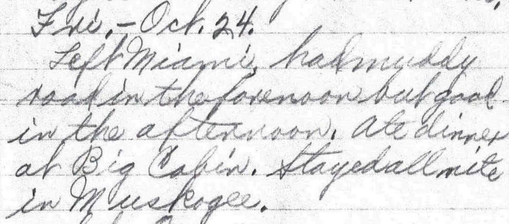
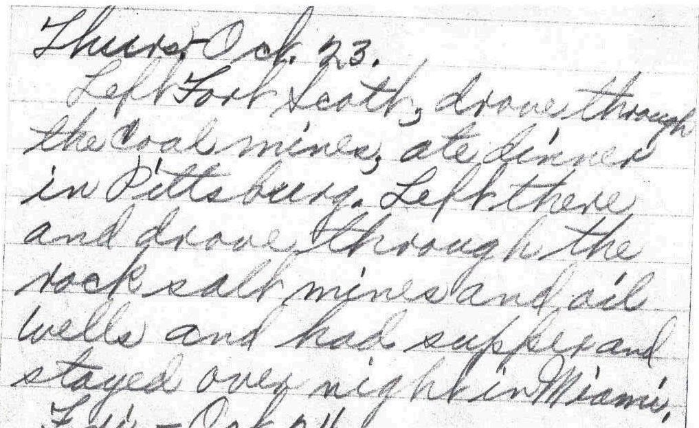
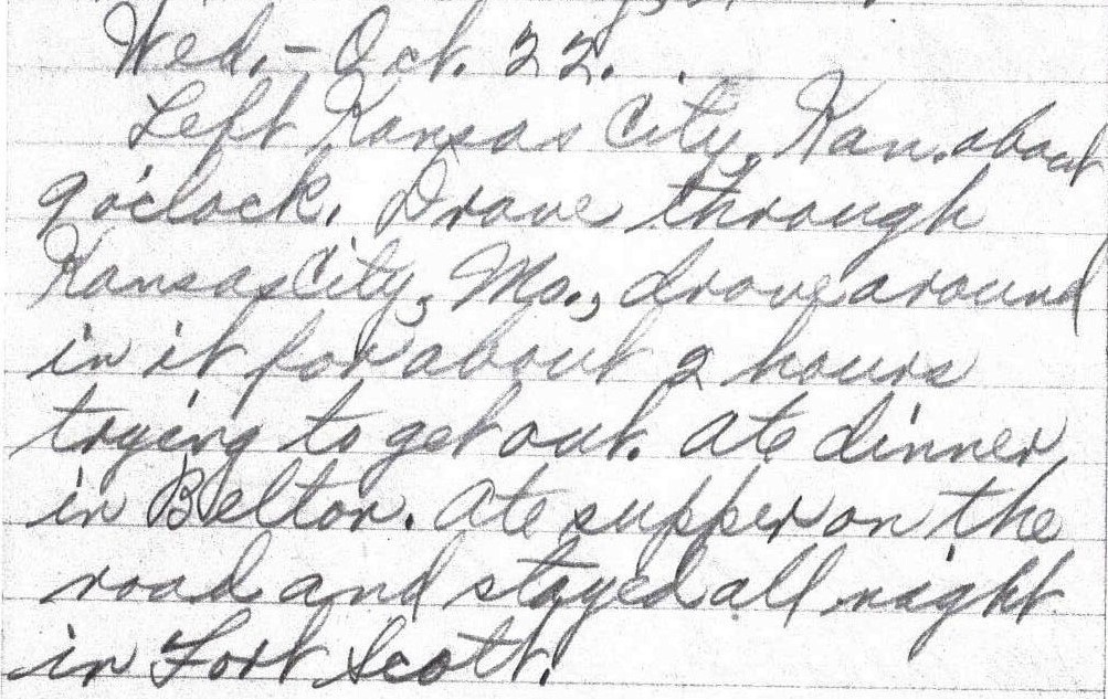
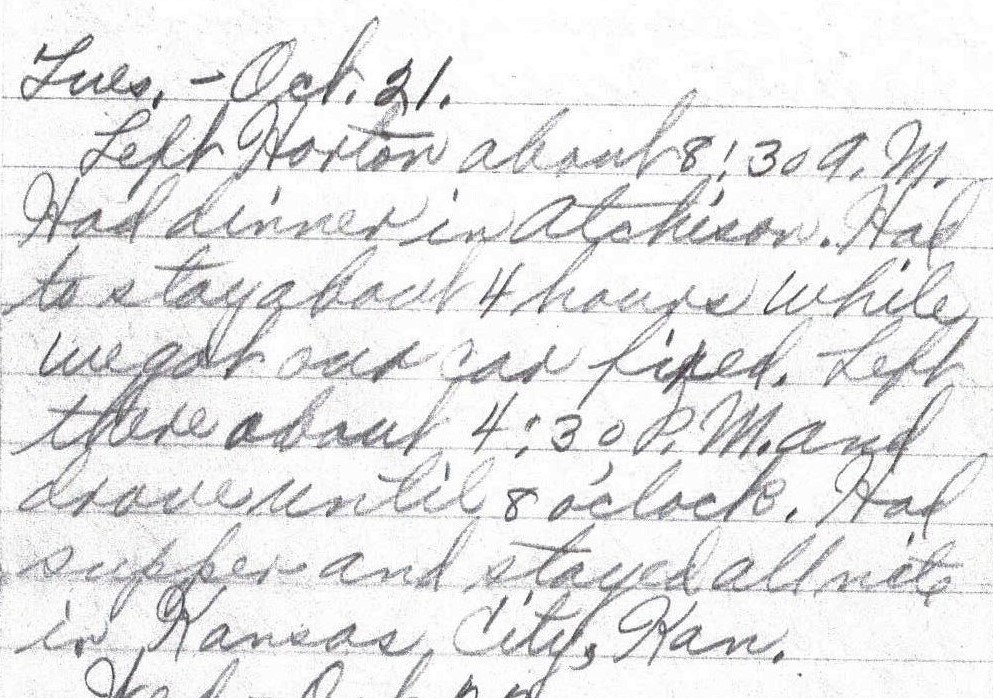
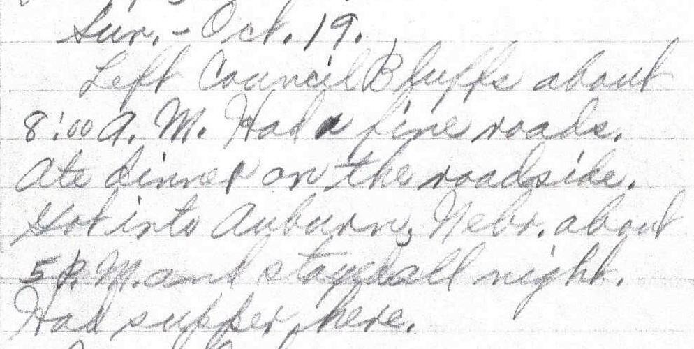
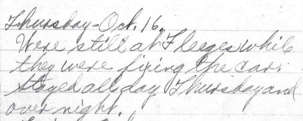
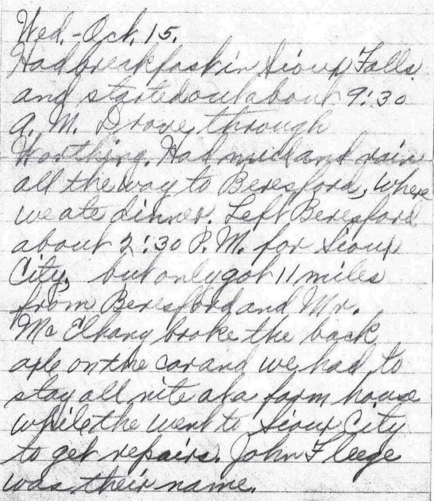
Fri. – Oct. 24.

Left Miami, had muddy road in the forenoon but good in the afternoon.  Ate dinner at Big Cabin. Stayed all nite in Muskogee. – Lena Bevers

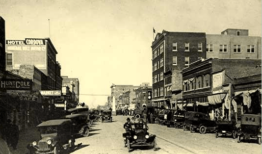
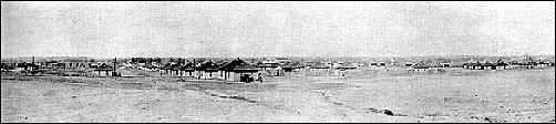
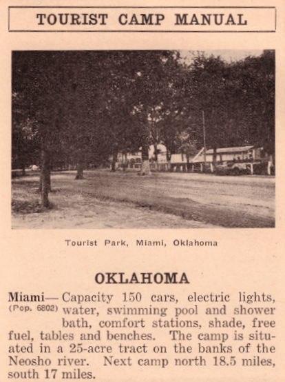
The town of Miami, Oklahoma, which was named after the Miami Indians and is pronounced “My-Am-Uh,”1 is only about 10 miles south of the border between Kansas and Oklahoma.  Presently, Miami’s Main Street is the longest main street on Historic Route 66.2  When the Bevers family arrived in Miami in 1919, Main Street was not yet designated as U. S. Highway 66.  That designation would not occur until the summer of 1926, and this designation “acknowledged the route as one of the nation’s principal east-west arteries.”3

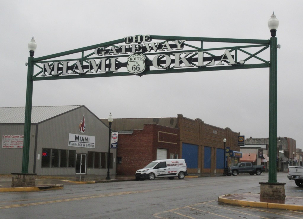
The Bevers family may have entered the town through the “Gateway.”

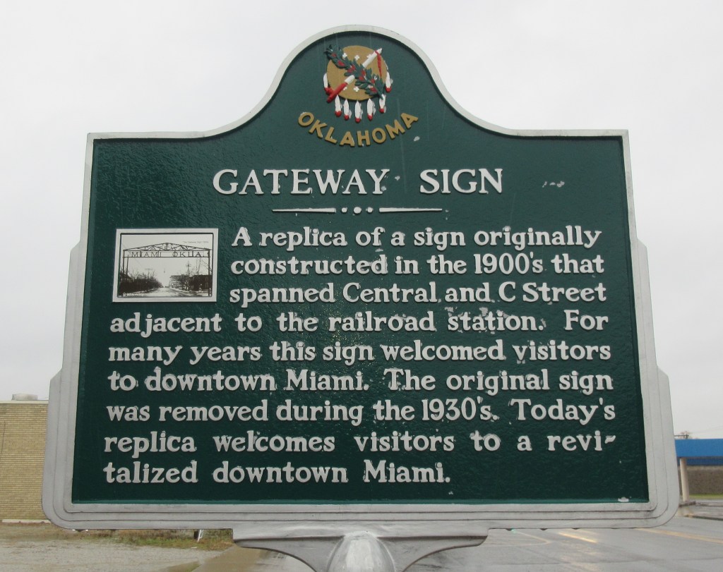
“In the early 1900s a steel arch greeted visitors entering Miami (by train), as it spanned East Central Avenue (between C and D Streets) next to the railway station. … The arch was removed in the 1930s.”4

“Gateway”, Miami, Oklahoma (Courtesy of John Scherer)5

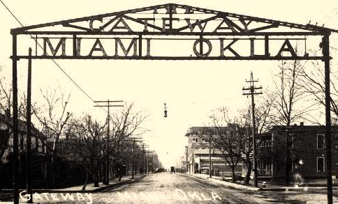
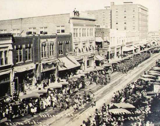
“As part of the city’s project to reinforce its Route 66 roots, a replica of the classic steel structure was planned in 2007. It was built and finally erected by Heck and Wicker Inc. in July 2012, but now on Main Street.

“The new steel structure with a triangular top, proclaims to all visitors ‘The Gateway, Miami, Okla.’”6

(Photograph by MRW October 24, 2019)
A view of Main Street in Miami, Oklahoma (Courtesy of John Scherer)6
Welcome Home Parade, Miami, Oklahoma, September 26, 1919. This event occurred one month before the Bevers Family drove through Miami. (Courtesy of John Scherer)

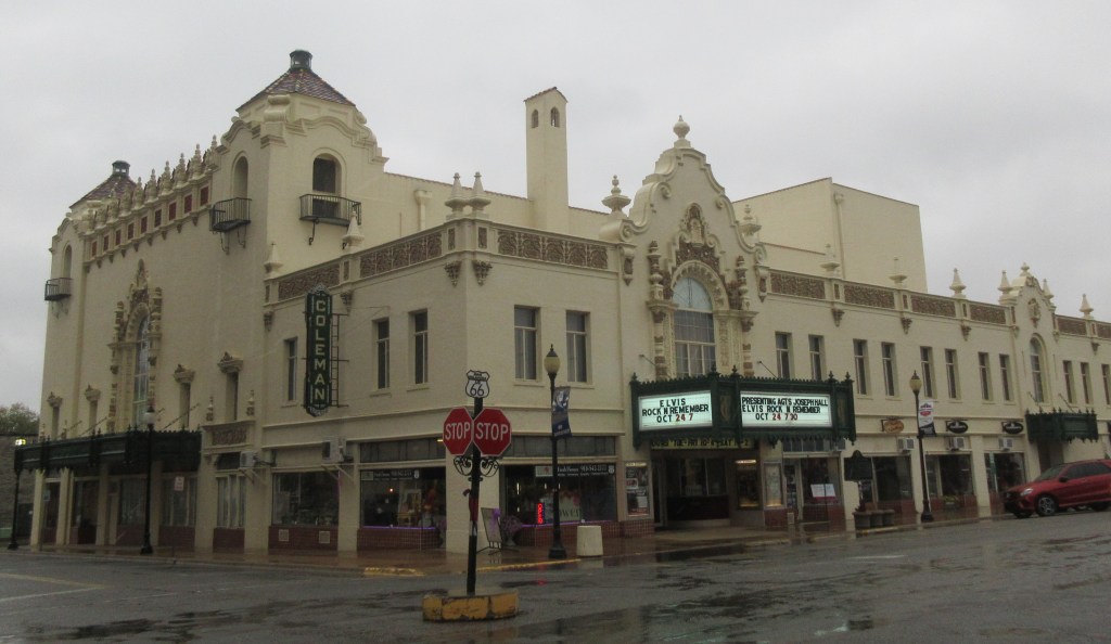
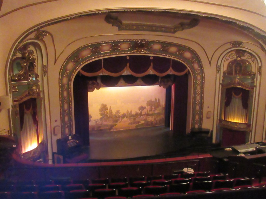
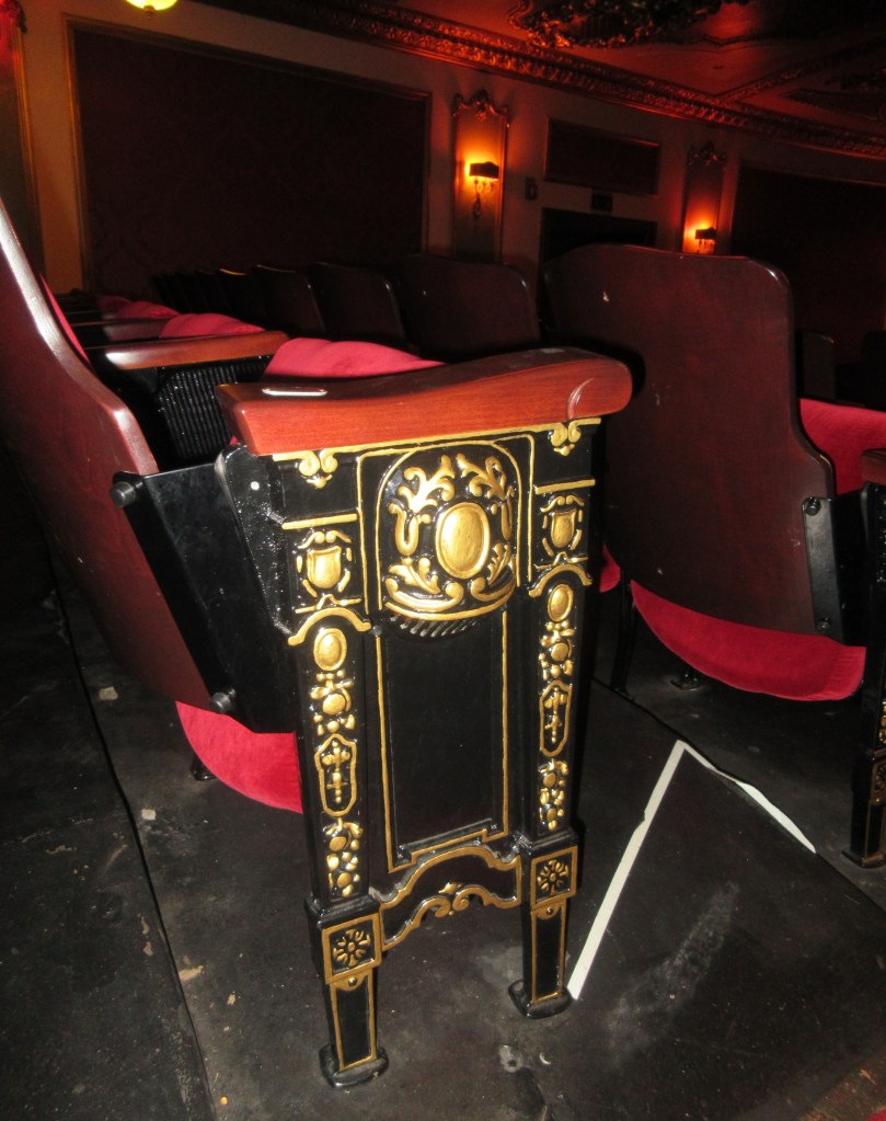
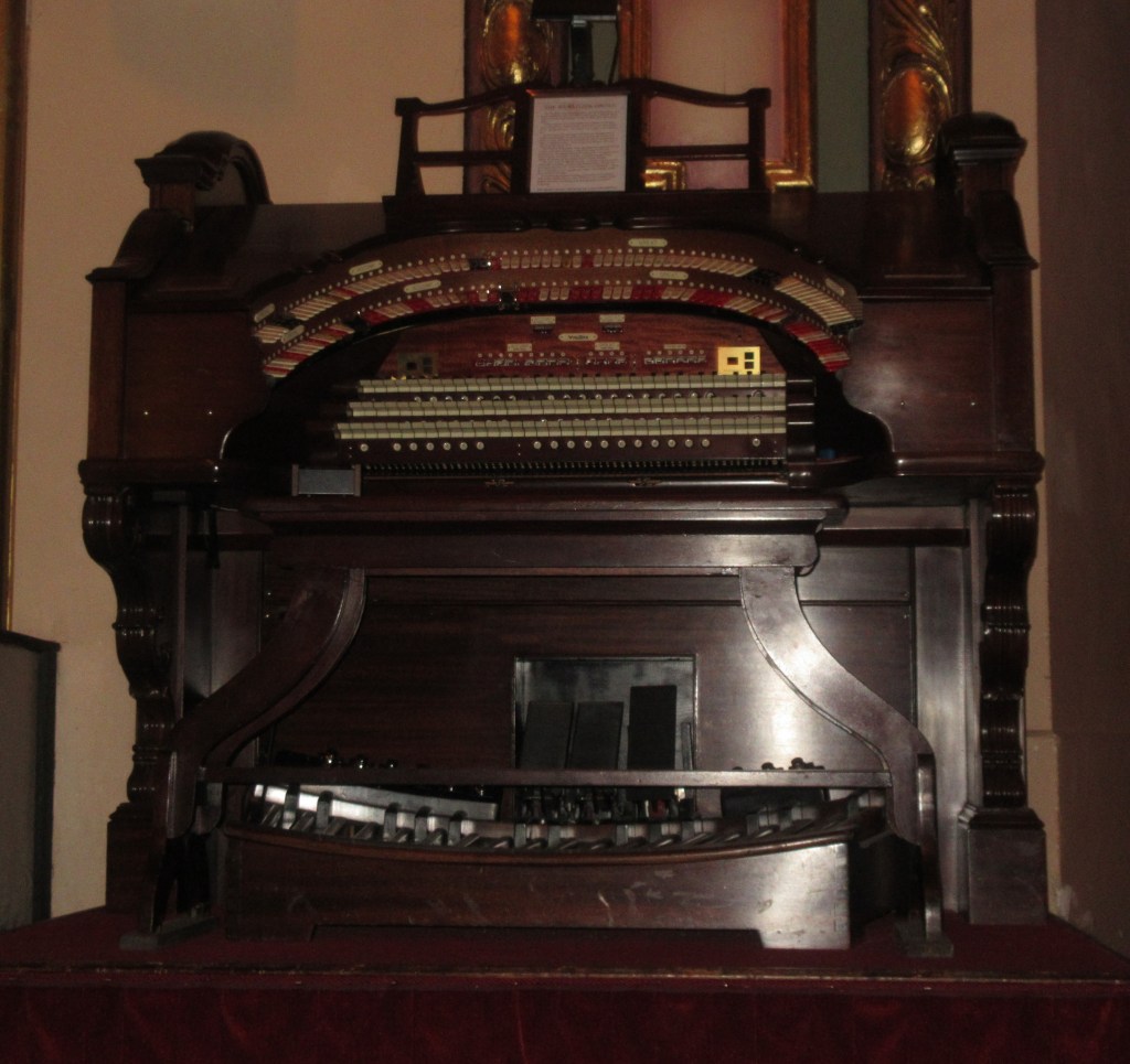
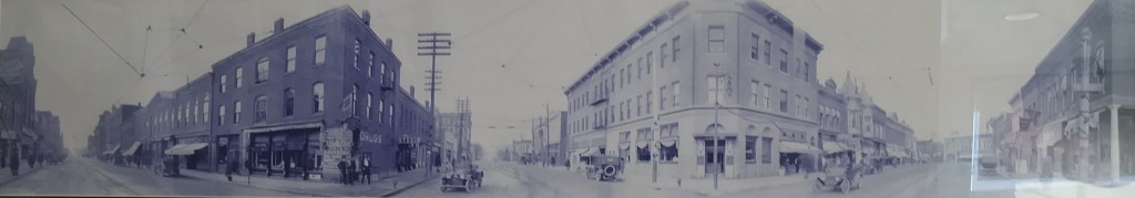
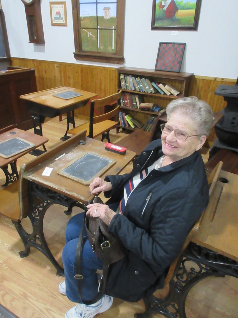
One of the architectural gems on Historic Route 66 is the Coleman Theater Beautiful, an historic vaudeville theatre with a Spanish Colonial Mission-style exterior and Louis XV interior, costing $600,000 to build.7  Tickets sold at $1.00 each when it opened April 18, 1929, ten years after Lena and Herbert had passed through the town.  Current “programming ranges from ballets and operas to country and western acts to jazz and dance bands. Plus, … silent movies with the ‘Mighty Wurlitzer’ providing the music and sound effects.”8  During a tour of the theater given by a woman who had begun performing on the Coleman Theater stage when she was about five years old (which was probably in the late 1940s), my mother and I were very impressed with the interior design, the carvings and paintings, and the care that devoted volunteers have given to restore the theater to its former glamour.

Coleman Theater Beautiful (Photograph by MRW October 24, 2019)
The backdrop on the stage is 90 years old (Photograph by MRW October 24, 2019)
One of the tasks volunteers completed during restoration was applying gold leaf throughout the theater (Photograph by MRW October 24, 2019)
One of the highlights of our tour was hearing this Wurlitzer organ play, the pipes are on each side of the stage. (Photograph by MRW October 24, 2019)

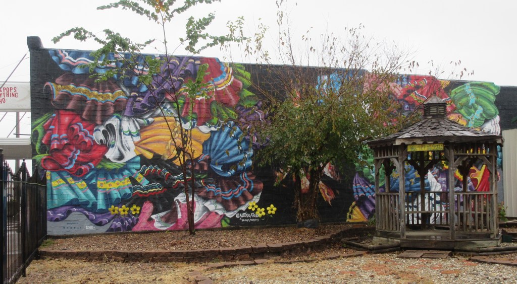
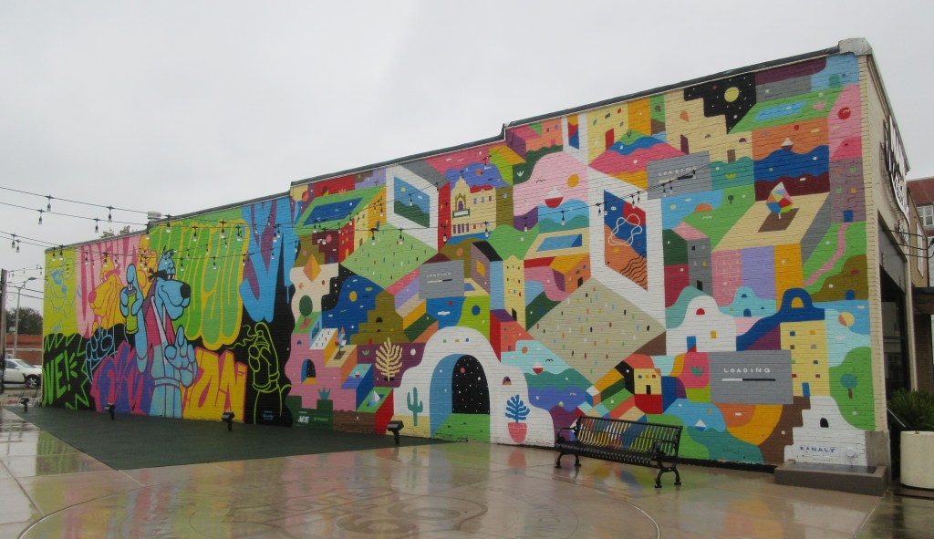
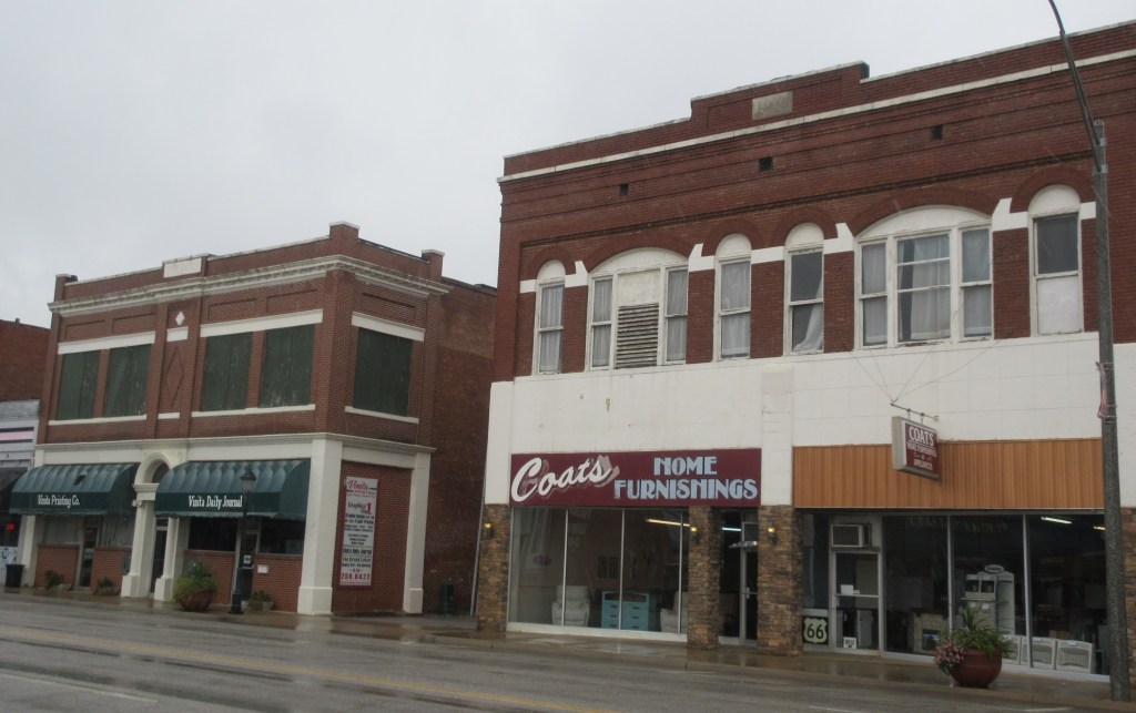
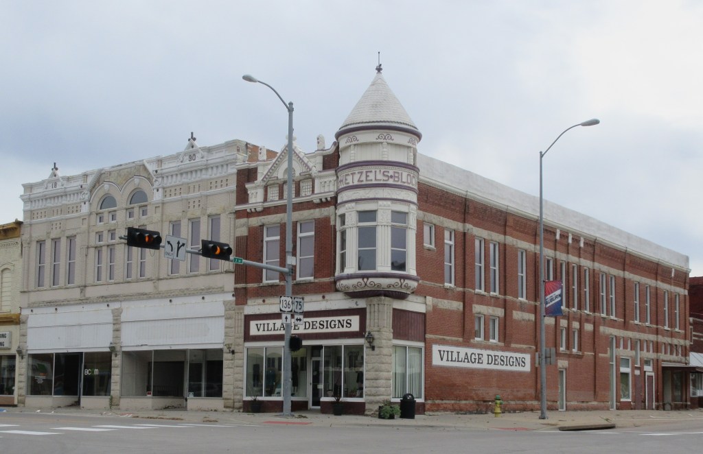
Two other beautiful sights on Main Street in Miami are murals painted on the side walls of buildings.

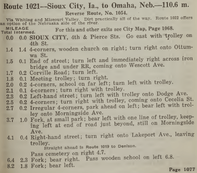
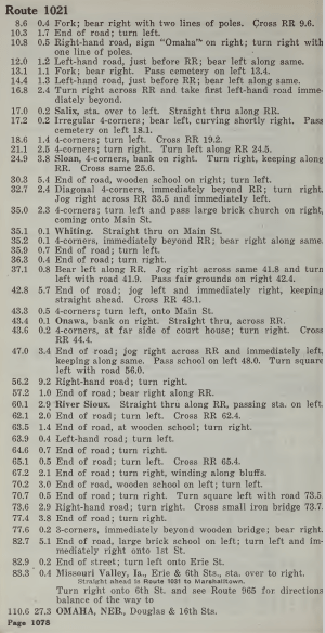
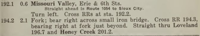
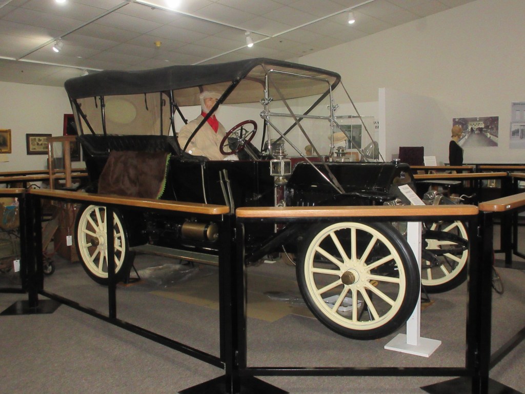
Herbert and Mr. McElhany drove about 100 miles on October 24, 1919.  Lena wrote that they had a muddy road on their way to Big Cabin, which is 40 miles from Miami.  Due to the muddy road they probably were driving about 10 miles per hour.  Then in the afternoon the road was good, so they accomplished the 60-mile drive to Muskogee at about 15 miles per hour.  According to The Official Automobile Blue Book 1920, the speed laws in Oklahoma were regulated by the towns and cities.9

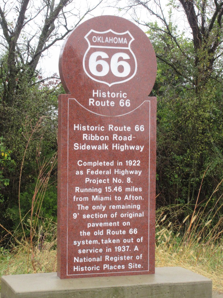
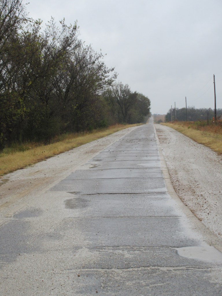
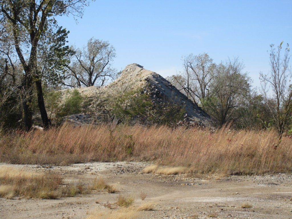
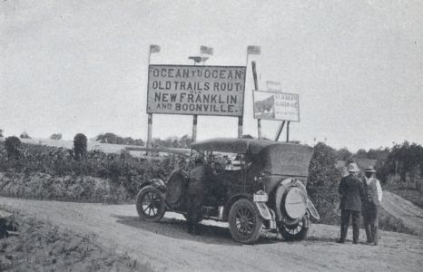
Before heading toward Big Cabin, we tried to locate a stretch of the original Historic Route 66.  It took about 45 minutes to find it because the directions I obtained from a website were not specific enough and there either wasn’t a road marker or we missed seeing a road marker.  When we felt we had gone too far, we asked my mother’s phone to navigate us to the location of The Ribbon Road and after passing it once, we finally located the road.  The Ribbon Road is only one lane.  “Legend has it that the funds were insufficient and that the engineers chose to build only one lane, nine-feet wide and pave the whole length between Miami and Afton rather than pave half the distance with a regular width road.”10

The Ribbon Road, a section of Historic Route 66 (Photograph by MRW October 24, 2019)

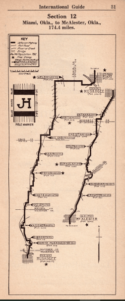
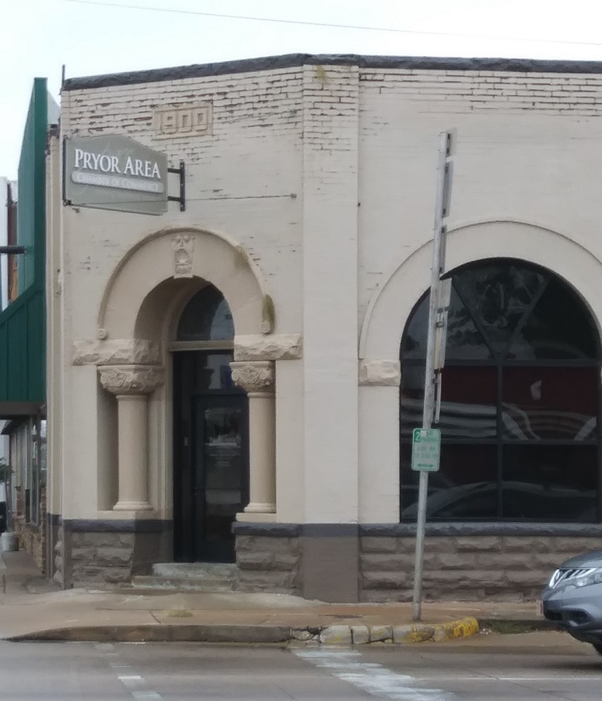
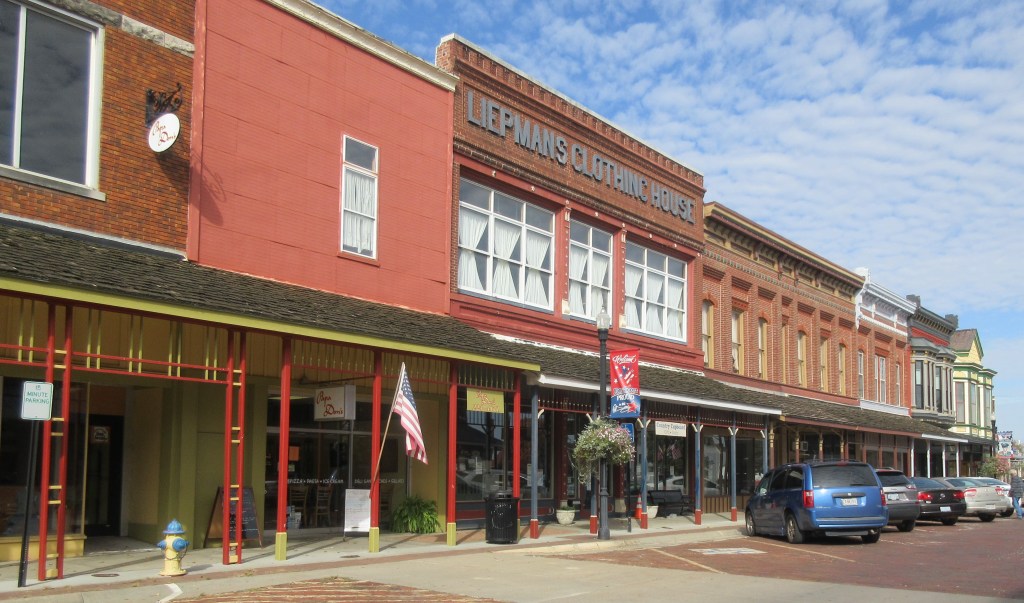
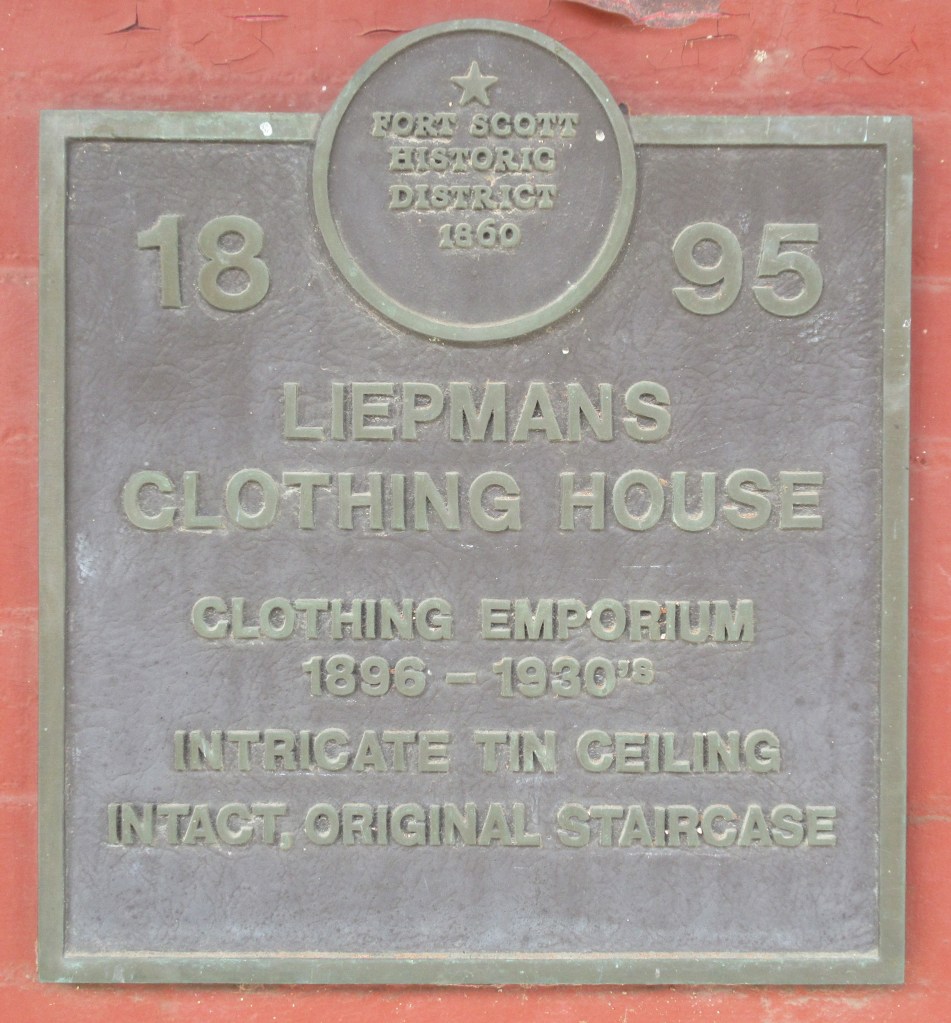
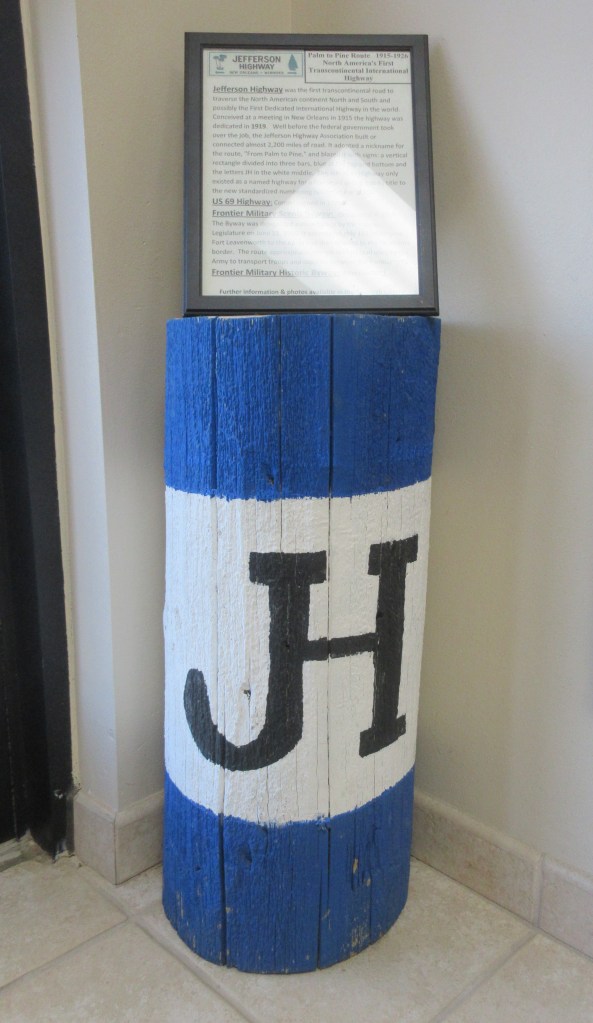
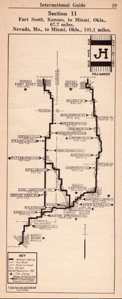
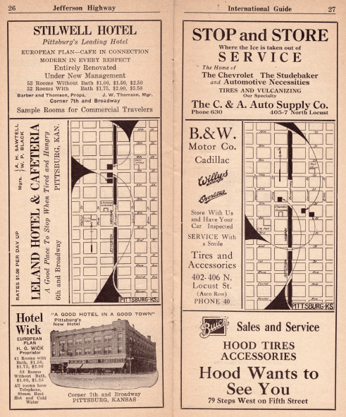
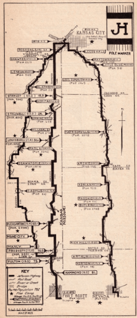
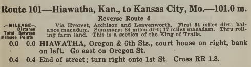
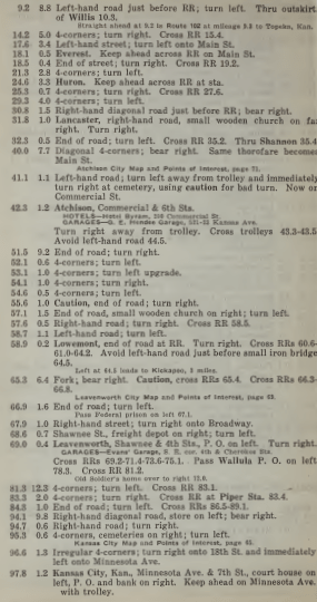
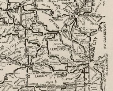
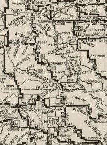
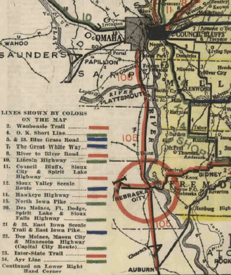
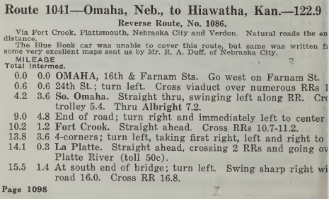
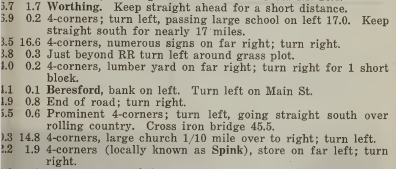
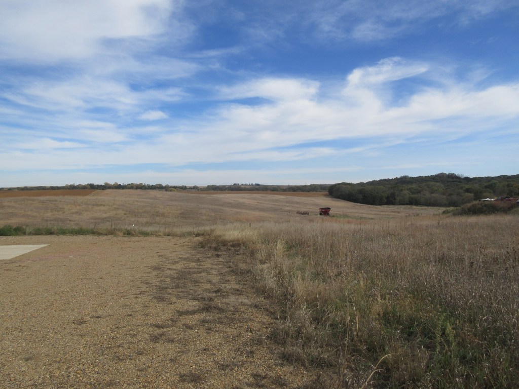
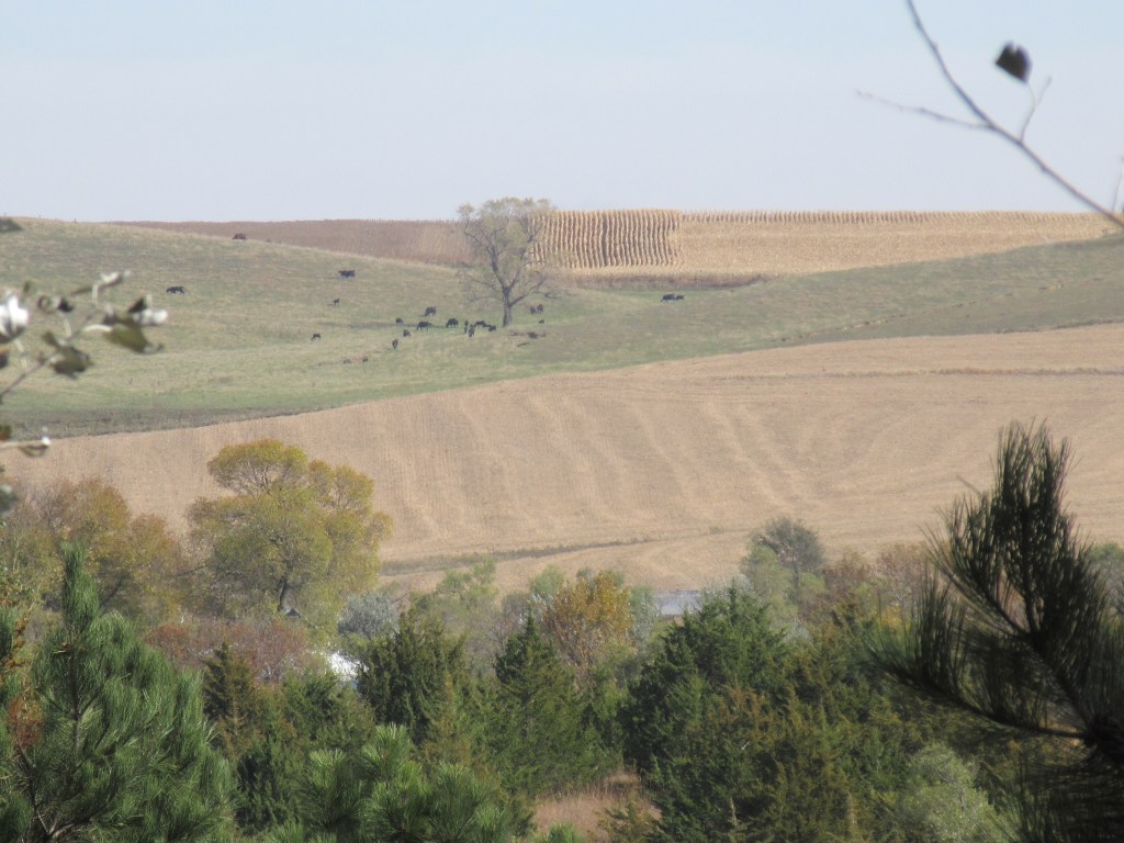
On the map below printed in the International Tourist Guide, the route on the left is the branch of the Jefferson Highway that the Bevers’ family traveled on this day.11  Route 36 in The Official Automobile Blue Book 1920 lists many of the towns that Lena and Florence record in their travel logs.  In the introduction to this route, it states: “This is a section of the King of Trails, the Jefferson highway and the Ozark trail.  Good supply stations and stopping places all along the route.”12 According to a 1924 Rand McNally map, the King of Trails Highway merged with the Jefferson Highway at Vinita.13  As my mother and I traveled this route, much of it on U. S. Highway 69, we found that the towns are still small except Muskogee.  In Big Cabin, where the Bevers had their dinner, there were only truck stops, so we decided to continue down the road to Pryor.  We ate lunch across the street from a building dated 1900.  Then continuing on, we arrived at our motel in Muskogee at 3:00 PM.

(Courtesy of Jefferson Highway Association)
Historic buildings in Vinita, the one on the right is dated 1910 (Photograph by MRW October 24, 2019)
Historic building in Pryor dated 1900 (Photograph by MRW October 24, 2019)

Notes:

  1. Miami Area Convention and Visitors Bureau, History, http://www.visitmiamiok.com/history/.
  2. Miami Area Convention and Visitors Bureau, Route 66 Miami Itinerary, http://www.visitmiamiok.com/map/route-66-miami-itenery/.
  3. National Park Service, U. S. Department of the Interior, https://www.nps.gov/nr/travel/route66/origins_of%20Route66.html.
  4. The Complete Route-66 Online Travel Guide, “Miami ‘Gateway’ Portico,” https://www.theroute-66.com/miami.html#gateway.
  5. Gateway, Miami, Okla., http://schehrer2.homestead.com/Miami25.html.
  6. The Complete Route-66 Online Travel Guide, “Miami ‘Gateway’ Portico.
  7. Main Street, Miami, Oklahoma, http://schehrer2.homestead.com/Miami25.html.
  8. Shannon Duhon, The Coleman Theater Beautiful, http://www.colemantheatre.org/opening-weekend.
  9. Shannon Duhon, The Coleman Theater Beautiful.
  10. Automobile Blue Book Publishing Company, The Official Automobile Blue Book 1920, vol. 7 (New York: Automobile Blue Book Publishing Company, 1920): 864, https://ia601208.us.archive.org/26/items/case_gv1024_a92_1920_v_7/case_gv1024_a92_1920_v_7.pdf.
  11. Road Trip Journeys, TheRoute-66.com Online Travel Guide, https://www.theroute-66.com/ribbon-road-us66.html.
  12. Jefferson Highway Association, International Tourist Guide, Jefferson Highway (Saint Joseph, Missouri: Combe Printing Co., 1923): 31.
  13. Automobile Blue Book Publishing Company, The Official Automobile Blue Book 1920, vol. 7: 98.
  14. Rand McNally and Company, Commercial Atlas of America, “Auto Trails Map, District No. 12, Southern Nebraska, Eastern Colorado, Kansas, Northeastern New Mexico, Northern Oklahoma” (Chicago: Rand & McNally and Company, 1924): 372-373, https://www.davidrumsey.com/luna/servlet/detail/RUMSEY~8~1~201708~3000668:AutoTrails-Map,-Southern-Nebraska.

Day Eleven: Fort Scott, Kansas to Miami, Oklahoma

October 23, 2019

Retracing Lena Huppler Bevers’ Travel Log

Thurs. – Oct. 23.

Left Fort Scott, drove through the coal mines, ate dinner in Pittsburg.  Left there and drove through the rock salt mines and oil wells and had supper and stayed over night in Miami. – Lena Bevers

This morning when my mother and I were eating our breakfast at a fast food place in Fort Scott, Kansas, on the wall behind us there was a panoramic photograph of downtown Fort Scott in 1917.  Here is a picture I took of that photograph:

The town of Fort Scott had its beginnings as a small settlement beside the frontier fort of the same name.  The fort was established in 1842 and was “charged with keeping the peace between American Indians and white settlers.”1  The fort was abandoned in 1853, but the town continued to grow.

West Wall Street, Fort Scott, Kansas in 1916 (Courtesy of Bourbon County Historical Preservation Association, Kansas)

Before departing Fort Scott today, we spent a short time visiting one of the historic downtown streets and the site of the military fort.  The grounds of the fort are maintained by the National Park Service.  We briefly perused two of the exhibit halls.

Historic Downtown Fort Scott, Kansas (Photograph by MRW October 23, 2019)
(Photograph by MRW October 23, 2019)
Fort Scott parade grounds (Photograph by MRW October 23, 2019)
This army escort wagon was restored by Werner Wagon Works, the workshop where we were given a tour in Horton, Kansas, three days ago. (Photograph by MRW October 23, 2019)
The bricks under this cannon appeared to be original from the 1800s. (Photograph by MRW October 23, 2019)

When Herbert and Lena headed south with their family on October 23, 1919, they continued driving on the Jefferson Highway. Lena recorded that they drove through coal mines. Southeastern Kansas was filled with mining camps at that time. Mining companies were mining for coal using underground mine shafts. This technique of coal mining declined during the 1920s and 1930s and the last mineshaft was closed in 1960.2 The region looks different now than it did when Lena and Herbert were here. As we traveled down U. S. Highway 69, there was an intermingling of woodlands, pastures and crop fields.

“The tipple, engine house, and tailing pile of former Crowe Company No. 16 shaft mine, active in the 1920’s.”3 (Courtesy of Kansas State Historical Society, Copy and Reuse Restrictions Apply)
“Part of Croweburg Camp as it existed between 1910 and 1920. “Crackerbox” houses are in the foreground and squarish houses appear in the background.”4 (Courtesy of Kansas State Historical Society, Copy and Reuse Restrictions Apply)
“Croweburg Camp in eastern Crawford county about 1920. Squarish houses with “hipped” roofs were common in the company camp.”5 (Courtesy of Kansas State Historical Society, Copy and Reuse Restrictions Apply)

Lena wrote in her travel log that the Bevers family ate their dinner in Pittsburg, Kansas.  As my mother and I were heading to Pittsburg to have lunch, we stopped in the town of Franklin and visited the Miners Hall Museum.

This replica of a pole marker of the Jefferson Highway was sitting in the Miners Hall Museum. (Photograph by MRW October 23, 2019)

A map from the Jefferson Highway International Guide shows two branches of the highway.6  The Bevers family was traveling on the branch on the left.  Lena’s daughter Florence recorded that they drove near Arma, Edward and Garland, had dinner in Pittsburg, then drove through Crestline, Riverton, Lowell, Baxter Springs, Picher, Cardin and Commerce.7

(Courtesy of Jefferson Highway Association)
(Courtesy of Jefferson Highway Association)8

One of the buildings that Lena and Herbert probably drove past in Pittsburg was the Stilwell Hotel.  The Jefferson Highway International Guide had an advertisement for the hotel.9  (See below in the upper left corner.)  On the opposite page there are advertisements of services for tourists.

(Courtesy of Jefferson Highway Association)
Stilwell Hotel (Photograph by MRW October 23, 2019)
At Baxter Springs, Historic U. S. Route 66 merged with U. S. Highway 69 (Photograph by MRW October 23, 2019)
Lena stated that they drove through rock salt mines and oil wells. This mound was the only evidence we saw along U. S. highway 69 of rock salt mining in the past and we did not see any oil wells. (Photograph by MRW October 23, 2019)

Lena only occasionally mentions the type of facility they stayed at each night.  The Jefferson Highway Association published a Tourist Camp Manual in 1923 which gives us a clue of what they may have done.  The manual identifies towns where tourists can camp along the highway.  One of the places noted in the manual is in Miami, Oklahoma.10  We ended our day by checking into a motel in Miami at 4:00 PM.

Notes:

  1. Kansas Historical Society, Fort Scott (February 2013), https://www.kshs.org/kansapedia/fort-scott/17808.
  2. William E. Powell, Former Mining Communities of the Cherokee-Crawford Coal Field of Southeastern Kansas (Kansas Historical Quarterly, vol. 38, no. 2, Summer 1972): 187-99, https://www.kshs.org/p/former-mining-communities-of-the-cherokee-crawford-coal-field/13222.
  3. William E. Powell, Former Mining Communities of the Cherokee-Crawford Coal Field of Southeastern Kansas: 187-99.
  4. William E. Powell, Former Mining Communities of the Cherokee-Crawford Coal Field of Southeastern Kansas: 187-99.
  5. William E. Powell, Former Mining Communities of the Cherokee-Crawford Coal Field of Southeastern Kansas: 187-99.
  6. Jefferson Highway Association, International Tourist Guide, Jefferson Highway (Saint Joseph, Missouri: Combs Printing Co., 1923): 29.
  7. B. Winkelmann, Our Trip to Texas [Transcription of Our Trip to Texas by Florence Bevers, 1919] (unpublished, n. d.): 2.
  8. Jefferson Highway Association, International Tourist Guide, Jefferson Highway: 22.
  9. Jefferson Highway Association, International Tourist Guide, Jefferson Highway: 26-27.
  10. Jefferson Highway Association, Tourist Camp Manual, Jefferson Highway (Saint Joseph, Missouri: Combe Printing Co., 1923): 37.

Day Ten: Kansas City, Kansas to Fort Scott, Kansas

October 22, 2019

Retracing Lena Huppler Bevers’ Travel Log

Wed. – Oct. 22.

Left Kansas City, Kan. about 9 o’clock.  Drove through Kansas City, Mo., drove around in it for about 2 hours trying to get out.  Ate dinner in Belton.  Ate supper on the road and stayed all night in Fort Scott. – Lena Bevers

The downtown business district of Kansas City, MO, is in the center background of this photo taken in 1915.1 (Courtesy of My Genealogy Hound)

On October 22, 1919 the Bevers family started their day by going across the Kansas river from Kansas City, Kansas to Kansas City, Missouri.  The running directions of Route 1042 of The Official Automobile Blue Book 1917 state that there was a 15-cent toll for crossing the Intercity Viaduct one-way and 25-cent toll for round-trip.2  (This is the bridge that crossed the Kansas River at Minnesota Avenue.)  But in the 1920 edition of the Blue Book, there is no toll.3  In 1917 Kansas City, Kansas and Kansas City, Missouri bought the bridge and in 1918 the two cities opened the bridge as a free bridge.4  So when Herbert and Mr. McElhany drove over the viaduct they didn’t have to pay a toll.  A sister bridge was built in 1962.  The two bridges are now called the Lewis and Clark Viaduct.  Presently, the eastbound lanes of Interstate Highway 70 travel over the original inter-city viaduct built in 1907.5  When my mother and I crossed the Kansas River today, we were driving on the same bridge that Herbert and Lena drove on.

(From The Official Automobile Blue Book 19206)

Upon entering Missouri, the speed law was: “‘Careful and prudent manner’; not exceeding 25 miles per hour.”7  After crossing the bridge, the two-car caravan somehow lost their way in Kansas City, Missouri.  They “drove around in it for about 2 hours trying to get out.”8  Possibly they were trying to exit the city on the King of Trails Highway.  Lena only mentions traveling through one town between Kansas City and their final destination, Fort Scott, which doesn’t provide enough information to determine on which side of the Kansas-Missouri border they traveled on.  Florence’s travel log gives additional information: “Drove thru Stillwell, Louisburg, La Cygne, Trading Post, Pleasanton, Linton, Prescott, Fulton, and stayed all night in Ft. Scott.”9  According to a 1924 Rand McNally map of Nebraska and Kansas, the King of Trails Highway does not travel through any of those towns.10  Apparently, the highway they got on was the Jefferson Highway, another north-south transcontinental route.

The Jefferson Highway was envisioned by Edwin Thomas Meredith, a businessman and political activist of Des Moines, Iowa.11  He and a group of associates organized the national Jefferson Highway Association in 1915, establishing its terminal points as Winnipeg, Canada and New Orleans, Louisiana.  This gave the Jefferson Highway the distinction of being the first international route to transect the United States.  The highway was named in honor of President Thomas Jefferson for his role in the Louisiana Purchase.  It was also known as the “From Pine to Palm” route and “The Vacation Route of America.”

The Jefferson Highway Association published a guide book in 1923 to assist tourists when they were traveling on the Jefferson Highway.12  The image below is a map of three branches of the Jefferson Highway from Kansas City, Missouri to Fort Scott, Kansas.  The center branch goes through some of the towns in Florence’s list.  The map also shows four branches within the city limits.  This is one example of road designations in the early 1900s that confused automobile tourists.

(Courtesy of Jefferson Highway Association)

While in Kansas City, Missouri, my mother and I decided to go to the National World War 1 Memorial.  World War 1 ended on November 11, 1918 and the site for this Memorial was dedicated on November 1, 1921.  At the time of their trip to Texas, Herbert and Lena had two sons serving in the army, Clarence and Edgar.13

(Photograph by MRW October 22, 2019)
A view of Kansas City, Missouri, from the observation deck of the Liberty Memorial Tower (Photograph by MRW October 22, 2019)

From our motel in Kansas City, Kansas, it took about 45 minutes to get to the Memorial and we found the location quite easily.  When we left the memorial, we chose to take the city streets instead of a freeway and it took us about 45 minutes until we were out of the suburbs of the city, only having a little difficulty staying on our route.  Then it took another twenty minutes to arrive at Belton, the town where Lena wrote that they had their dinner.  Belton has an historical main street and we decided to have our lunch at a café that was decorated with Betty Boop and other retro décor.  It was nearly 2:00 PM when we ordered our lunch, a bison burger for me and a grilled ham and cheese for my mother.

(Photograph by MRW October 22, 2019)
This restored building in Belton, Missouri, is where we ate our lunch. (Photograph by MRW October 22, 2019)

When we left Belton, we traveled on a winding country road (Route Y), which eventually took us across the state border, back into Kansas. Upon arriving at Louisburg, one of the towns Florence mentioned, our only option to continue toward Fort Scott was U. S. Highway 69, a modern freeway.  A few times we got off the freeway to drive through towns in Florence’s list.  Two of the towns are utilizing old buildings for public libraries.  In Prescott, the library had formerly been a school house and we were invited inside to see the upstairs room that was set up as an historical classroom. We finally arrived at our motel at 5:00 PM.

Louisburg Public Library is in a 1917 building.(Photograph by MRW October 22, 2019)

Notes:

  1. Kansas City, Missouri, 1915, Business District, http://www.mygenealogyhound.com/vintage-photographs/missouri-photographs/MO-Kansas-City-Missouri-1915-Business-District-historic-photo.html.
  2. Automobile Blue Book Publishing Company, The Official Automobile Blue Book 1917, vol. 5 (New York: Automobile Blue Book Publishing Company, 1917): 1102, https://ia800405.us.archive.org/15/items/case_gv1024_a92_1917_vol_5/case_gv1024_a92_1917_vol_5.pdf.
  3. Automobile Blue Book Publishing Company, The Official Automobile Blue Book 1920, vol. 7 (New York: Automobile Blue Book Publishing Company, 1920): 165, https://ia601208.us.archive.org/26/items/case_gv1024_a92_1920_v_7/case_gv1024_a92_1920_v_7.pdf.
  4. Intercity Viaduct, https://en.wikipedia.org/wiki/Intercity_Viaduct.
  5. Intercity Viaduct, https://en.wikipedia.org/wiki/Intercity_Viaduct.
  6. Automobile Blue Book Publishing Company, The Official Automobile Blue Book 1920, vol. 7: 65-66.
  7. Automobile Blue Book Publishing Company, The Official Automobile Blue Book 1920, vol. 7: 863.
  8. Lena Bevers, Our Trip to Texas (unpublished, 1919): 3A.
  9. B. Winkelmann, Our Trip to Texas [Transcription of Our Trip to Texas by Florence Bevers, 1919] (unpublished, n. d.): 2.
  10. Rand McNally and Company, Commercial Atlas of America, “Auto Trails Map, District No. 12, Southern Nebraska, Eastern Colorado, Kansas, Northeastern New Mexico, Northern Oklahoma” (Chicago: Rand McNally & Company, 1924): 372-373, https://www.davidrumsey.com/luna/servlet/detail/RUMSEY~8~1~201708~3000668:AutoTrails-Map,-Southern-Nebraska.
  11. Iowa Department of Transportation, History of the Interstate Trail, Jefferson Highway and Jefferson Association: 1, https://iowadot.gov/autotrails/history-of-the-jefferson-highway.
  12. Jefferson Highway Association, International Tourist Guide, Jefferson Highway (Saint Joseph, Missouri: Combs Printing Co., 1923): 25, https://jeffersonhighway.org/resources/Documents/JH-International-Tourist-Guide-1923.pdf.
  13. C. M. Bevers, personal communication with E. J. Jones (October 17, 2019).

Day Nine: Atchison to Kansas City, Kansas

October 21, 2019

Retracing Lena Huppler Bevers’ Travel Log

Tues. – Oct. 21.

Left Horton about 8:30 A. M.  Had dinner in Atchison.  Had to stay about 4 hours while we got our car fixed.  Left there about 4:30 P. M. and drove until 8 o’clock.  Had supper and stayed all nite in Kansas City, Kan. – Lena Bevers

When Herbert Bevers and Mr. McElhany got on the road on October 21, 1919, they started out from Horton, Kansas at 8:30 AM.  Horton is 12 miles south of Hiawatha and about five miles west of Everest.  The town cannot be found on the running directions of Route 101 of The Official Automobile Blue Book 1920 (see below) because Horton is west of the route described, but starting at mile 18.1 we can follow the route that the two cars probably took to get to Kansas City, Kansas.  Florence Bevers wrote in her travel log that they drove through Everest, Huron, Lancaster, Shannon, Leavenworth, Lansing, Wallula and Piper.1  Many of these towns are listed in Route 101. The introduction to Route 101 states that this route is a section of the King of Trails – confirmation that Herbert Bevers and Mr. McElhany were driving on the King of Trails.2

A section of a 1924 Rand-McNally map showing a route from Horton to Kansas City, Kansas.3

When the two cars arrived in Atchison, Herbert had to get their car fixed which took about four hours.  Florence stated “they fixed the timer on our car.”4  In the above extract from the 1920 Blue Book, there is an advertisement for a garage.5  Maybe this is where the work was done on the Bevers’ car.  When Florence wrote “timer,” perhaps she was referring to the odometer, which would have been very important for keeping track of the distance traveled, if they were following running directions, such as those in the 1920 Blue Book

In the description of Atchison above, at the end of the article it mentions the “splendid” public buildings: a $125,000 Atchison County Court House and a $100,000 U. S. Post Office.6  When my mother and I left our motel, we drove around the city to see some of the sights.  We went to the courthouse, the post office, the river front and the pedestrian mall.  I needed to mail a letter so I went inside the post office to buy envelopes and stamps.  The woodwork in the lobby was beautiful.

Atchison County Court House (Photograph by MRW October 21, 2019)
In 1869, Abraham Lincoln gave an address near the corner of 5th Street and Parallel Street in Atchison, Kansas (Photograph by MRW October 21, 2019)
U. S. Post Office, Atchison, Kansas (Photograph by MRW October 21, 2019)
Interior of the U. S. Post Office, Atchison, Kansas (Photograph by MRW October 21, 2019)
Amelia Earhart was born in Atchison, Kansas. A bronze statue of her stands in the middle of the pedestrian mall of Commercial Street, Atchison, Kansas. Around the base of the statue are the words: “Let there be peace on earth, and let it begin with me.” (Photograph by MRW October 21, 2019)
Commercial Street, Atchison, Kansas, about 19107 (Courtesy of My Genealogy Hound)

After our tour of Atchison, we headed south on U. S. Highway 73 which closely follows the King of Trails route.  At mile 66.9 in the Route 101 running directions above, it tells the driver to pass a federal prison on the left.8  When we reached the point on U. S. Highway 73 where it seemed the prison should be, we searched the landscape for a building that looked like a prison.  Finally, as we came over a hill, there on the left was a huge building.  It was the United States Penitentiary at Leavenworth, a very impressive building.  A sign in front of the grounds declared that photos were not to be taken, so I cannot post any pictures.  Construction of the building began in March 1897 and continued for about 25 years.9  To see a picture of the prison, go to the Federal Bureau of Prisons website: https://www.bop.gov/locations/institutions/lvn/index.jsp.

Between Leavenworth and Kansas City, instead of the farm land we had been viewing for a week, we traveled through urban and suburban commercial districts and residential districts.  U. S. Highway 73 becomes a modern four-lane highway south of Lansing.  According to the introduction to Route 101 above, the Bevers family drove on dirt until they were within 17 miles of Kansas City, then they drove on macadam.10  Leaving Atchison at 4:30 PM, they drove about 55 miles and arrived in Kansas City about 8:00 PM. On this stretch, they drove almost 16 miles per hour.

Upon our approach to Kansas City, Kansas, my mother and I had difficulty finding our way to our motel, because our printed instructions weren’t correct, and I couldn’t understand how to read the Triptik from AAA.  So, we entered the address of the motel in the Garman navigation device and trusted it to lead us to the motel. By using this method, we had to take a freeway to get to our destination.  It worked and we arrived at our motel around 3:00 PM. 

Notes:

  1. B. Winkelmann, Our Trip to Texas [Transcription of Our Trip to Texas by Florence Bevers, 1919] (unpublished, n. d.): 2.
  2. Automobile Blue Book Publishing Company, The Official Automobile Blue Book 1920, vol. 7 (New York: Automobile Blue Book Publishing Company, 1920): 163-64, https://ia601208.us.archive.org/26/items/case_gv1024_a92_1920_v_7/case_gv1024_a92_1920_v_7.pdf.
  3. Rand McNally and Company, Commercial Atlas of America, “Auto Trails Map, District No. 12, Southern Nebraska, Eastern Colorado, Kansas, Northeastern New Mexico, Northern Oklahoma” (Chicago: Rand McNally & Company, 1924): 372-73, https://www.davidrumsey.com/luna/servlet/detail/RUMSEY~8~1~201708~3000668:AutoTrails-Map,-Southern-Nebraska.
  4. B. Winkelmann, Our Trip to Texas: 2.
  5. Automobile Blue Book Publishing Company, The Official Automobile Blue Book 1920, vol. 7: 71.
  6. Automobile Blue Book Publishing Company, The Official Automobile Blue Book 1920, vol. 7: 71.
  7. Commercial Street, Atchison, Kansas, (ca. 1910), http://www.mygenealogyhound.com/vintage-postcards/kansas-postcards/KS-Atchison-Kansas-Commercial-Street-vintage-postcard.html#
  8. Automobile Blue Book Publishing Company, The Official Automobile Blue Book 1920, vol. 7: 164.
  9. United States Penitentiary, Leavenworth, https://en.wikipedia.org/wiki/United_States_Penitentiary,_Leavenworth.
  10. Automobile Blue Book Publishing Company, The Official Automobile Blue Book 1920, vol. 7: 163.

Day Eight: Percival, Iowa to Atchison, Kansas

October 20, 2019

Retracing Lena Huppler Bevers’ Travel Log

Mon. – Oct. 20.

Stayed in Auburn till 12 A. M. while they fixed on the cars.  Ate dinner and then we pulled out.  Got into Horton about 6 P. M.  Had supper and stayed all night. – Lena Bevers

Lena writes in her travel log that the traveling party spent the morning of October 20 in Auburn, Nebraska because the men needed to fix their cars.  Florence adds that “they fixed the fan on our car and the frame on McElhaney’s car.”1  My mother and I didn’t head down the road right away either.  In the 2018 AAA TourBook Guide for Nebraska, my mother found the Arbor Day Farm in Nebraska City.  This farm is operated by the Arbor Day Foundation, whose mission statement is: “We inspire people to plant, nurture, and celebrate trees.”2  We spent the morning viewing some of their informative exhibits, walking one of their trails and experiencing a very unique attraction: Treetop Village.  If you are looking for evidence that you still have a kid in you, then try this out.

(Photograph by MRW October 20, 2019)

Lena stated that they headed down the road from Auburn at 12:00 PM after they ate dinner.  Today we started down the road from Nebraska City about 12:30 PM after sharing a caramel apple at the Arbor Day Farm.  U. S. Highway 75 roughly follows the King of Trails Highway until north of Dawson, Nebraska, then U. S. Highway 73 follows the King of Trails.  Florence recorded that they traveled through Howe, Stella, and Verdon in Nebraska, then Reserve and Hiawatha in Kansas.3  The two-car caravan ended their day in Horton, Kansas at about 6:00 PM.  In six hours, they had traveled about 63 miles, at not much more than 10 miles per hour.

Extract of Route 1041 from The Official Automobile Blue Book 19174

When my mother and I traveled down U. S. Highway 75, we went past and through several very small towns, for example Verdon has a population of 172.  We could not find a business district in Verdon nor did we find one in Reserve.  Auburn, the town where the Bevers family spent the previous night is small also, as well as Horton where they stopped on this day.  Hiawatha was the largest town we drove through.  It was very interesting to see the well-maintained historical buildings there.

Hetzel’s Block in Auburn, Nebraska, dated 1890 (Photograph by MRW October 20, 2019)
This building in Horton is dated 1915. The stone above the window says “Motor Inn.” (Photograph by MRW October 20, 2019)
Originally called the Hiawatha Memorial Auditorium, this 1920 building houses the Brown County Historical Society. (Photograph by MRW October 20, 2019)
Brick paved streets encircle the Courthouse Square of Hiawatha. (Photograph by MRW October 20, 2019)
Lawrence Building, Hiawatha, Kansas, dated 1896 (Photograph by MRW October 20, 2019)

In 1919, the speed laws in Kansas were: “‘Reasonable and proper.’ ‘A rate of speed in excess of 25 miles an hour shall be presumptive evidence of driving at a rate which is not careful and prudent in case of injury to the person or property of another.’  Twelve miles per hour in city limits; eight miles an hour at crossings, intersections, bridges, curves, descents, etc.  Six miles an hour at city intersections.”5  The 1920 edition of The Official Automobile Blue Book informed its readers that: “There is now a great interest in Kansas in the matter of good roads, and many miles of macadam, brick and concrete are being constructed under the supervision of the state highway commission.”6

When the Bevers family passed through Hiawatha, they crossed over another transcontinental highway. Below is a section of a Rand McNally map dated 1924, designating the King of Trails Highway with the number 27.7  (As I’ve mentioned before, this number corresponds to the map legend, it is not a highway number assigned by a governmental agency.)  At Hiawatha the King of Trails intersects with the Pikes Peak Ocean-to-Ocean Highway (number 47 on the map.)  The Ocean-to-Ocean Highway connected New York City with Los Angeles.8

Section of Rand McNally Map of Nebraska & Kansas, 1924
Ocean to Ocean Highway, 1913 (Public Domain; Courtesy of Federal Highway Administration)

We didn’t stay in Horton as Lena’s family did because we weren’t able to locate online a motel in Horton, so instead we made a reservation in Atchison, Kansas.  Before leaving Horton for our motel, we stopped at Werner Wagon Works.  The proprietors restore and manufacture wagons in the style that were used in the eighteen hundreds.  They kindly gave us a tour of their workshop.  It was fascinating to see and imagine how our ancestors traveled before automobiles were invented.

An army escort wagon that will be restored by Werner Wagon Works. (Photograph by MRW October 20, 2019)
A restored wagon completed about 1991 (Photograph by MRW October 20, 2019)
Some of the restoration work is completed with this band saw built in the early nineteen hundreds. (Photograph by MRW October 20, 2019)

Notes:

  1. B. Winkelmann, Our Trip to Texas [Transcription of Our Trip to Texas by Florence Bevers, 1919] (unpublished, n. d.): 2.
  2. Arbor Day Foundation, https://www.arborday.org/generalinfo/about.cfm.
  3. B. Winkelmann, Our Trip to Texas: 2.
  4. Automobile Blue Book Publishing Company, Official Automobile Blue Book 1917, vol. 5 (New York: Automobile Blue Book Publishing Company, 1917): 1099-1100, https://ia800405.us.archive.org/15/items/case_gv1024_a92_1917_vol_5/case_gv1024_a92_1917_vol_5.pdf.
  5. Automobile Blue Book Publishing Company, Official Automobile Blue Book 1917, vol. 5: 1234.
  6. Automobile Blue Book Publishing Company, Official Automobile Blue Book 1920, vol. 7 (New York: Automobile Blue Book Publishing Company, 1920): 859, https://ia601208.us.archive.org/26/items/case_gv1024_a92_1920_v_7/case_gv1024_a92_1920_v_7.pdf.
  7. Rand McNally and Company, Commercial Atlas of America, “Auto Trails Map, District No. 12, Southern Nebraska, Eastern Colorado, Kansas, Northeastern New Mexico, Northern Oklahoma” (Chicago: Rand McNally & Company, 1924): 372-373, https://www.davidrumsey.com/luna/servlet/detail/RUMSEY~8~1~201708~3000668:AutoTrails-Map,-Southern-Nebraska.
  8. Rick Martin, “The Highway,” Pikes Peak Ocean to Ocean Highway, http://www.ppoo.org/.

Day Seven: Council Bluffs to Percival, Iowa

October 19, 2019

Retracing Lena Huppler Bevers’ Travel Log

Sun. – Oct. 19.

Left Council Bluffs about 8:00 A. M.  Had fine roads.  Ate dinner on the roadside.  Got into Auburn, Nebr. about 5 P. M. and stayed all night.  Had supper here. – Lena Bevers

On this day one hundred years ago, Lena only recorded their starting and ending points.  This isn’t much information to determine the route that they took on this day.  Council Bluffs is on the east side of the Missouri River and Auburn is on the west side of the river, so one question is: Where did they cross the Missouri River?  They could have crossed from Council Bluffs into Omaha, or they could have traveled south and crossed at Nebraska City.  To make the choice, initially I referred to the Map of Iowa Showing Principal Automobile Routes, dated 1919, which I obtained from the Iowa Department of Transportation website.  A portion of the King of Trails Highway is highlighted on this map, indicating that the highway crossed the Missouri River at Omaha and traveled south through Plattsmouth, Nebraska City and Auburn.1  So that is the route that I chose.  Just a couple weeks ago, when my mother obtained from her cousin a copy of Florence Bevers’ travel log, we found confirmation that Herbert and Mr. McElhany did follow the King of Trails Highway into Omaha and then traveled south.  Florence wrote: “Left Council Bluffs, ate breakfast on our way, same as always, about 8 am.  Had fine roads.  Drove thru Omaha, Albright, Ft. Crook, Plattsmouth, Murry, Union, Wyoming and Nebraska City. Ate dinner on the roadside.  Got into Auburn, Nebraska about 5 pm and stayed all night.  Stopped early so they could fix the car.”2

Section of the Map of Iowa Showing Principal Automobile Routes

The bridge they would have used was one that between 1913 and 1930 was called the Lincoln Highway Bridge, which was a toll bridge.  At the end of Lena’s travel log, she notes that they crossed four toll bridges.  The King of Trails and the Lincoln Highways both crossed the Missouri River on the Lincoln Highway Bridge.  Originally this bridge was called Douglas Street Bridge.  It was a truss bridge built by Omaha and Council Bluffs Street Railway Company in 1888, designed to handle streetcars. On the photograph below, note the signs on each side of the bridge with the capital letter L.  These were the signs posted to indicate to the motorists that they were on the Lincoln Highway. 

Photograph of the Douglas Street Bridge by Omaha Daily Bee in July 1914. (Public Domain.)3

In 1938 a group of businessmen called the Knights of Ak-Sar-Ben (by the way, read this word backwards), bought the bridge with the intentions of making it a free bridge, which they accomplished in 1947.4  The bridge which was then named the Ak-Sar-Ben Bridge served the two cities until November 1966 when the Interstate Highway 480 Bridge was opened.  All that is left of the Ak-Sar-Ben Bridge is an east pier near the east bank of the river, south of the I-480 Bridge.

The first thing my mother and I did this morning was drive to River’s Edge Park in Council Bluffs.  It was a lovely morning and very pleasant for walking partway across the pedestrian bridge that spans the Missouri River and viewing the motivating statue that stands in the park.

(Photograph by MRW October 19, 2019)
The Interstate 480 Bridge entering Omaha (Photograph by MRW October 19, 2019)
The Interstate Highway 480 Bridge is the bridge we used to cross the Missouri River (Photograph by MRW October 19, 2019)

Herbert and Lena’s daughter-in-law Gladys Daily Bevers was born in Omaha.  Gladys’ mother Maggie Bonewitz Daily moved with her parents to Omaha from Fairfield, Iowa in 1880 and her father Charles Daily, who worked his way west from Indiana, arrived in Omaha about 1888.  Charles and Maggie married in 1891 and except for a short stint of farming near Topeka, Kansas they stayed in Omaha until 1915.

On Easter Sunday in March 1913, there was a devastating tornado that swept through Omaha and destroyed hundreds of homes.  Today, my mother and I did some research in the Omaha Public Library and found an article in the Omaha World-Herald that confirmed that the home of Gladys’ grandmother, Josephine Bonewitz, was destroyed.5  Charles and Maggie’s home, two blocks away, was also destroyed, although they were not living in it at the time.  Their son Robert has related that they had returned to Omaha from Kansas ten days before Easter and were waiting to move into their house at the beginning of the next month.6  Robert also explains that following the tornado, his father and Maggie’s brother H. Finley built a cottage for Josephine and a house for the Dailys.  A year after the tornado, the Daily home was photographed at the same address as their
former house, so it may be concluded that this is the re-built home.  In 1915 the Daily family moved to a farm north of Watertown, South Dakota.

Charles and Maggie Daily’s Home in Omaha in March, 1914
Courtesy of My Genealogy Hound7

In 1919 upon entering Nebraska, the speed law was: “Reasonable and proper; not to exceed 25 miles per hour in any case, 12 miles in the city limits, 8 miles at an intersection, bridge, etc.; at intersection of streets in city, 6 miles.”8  In Omaha the Lincoln Highway broke away from the King of Trails Highway, traveling west toward Cheyenne, Wyoming, while the King of Trails Highway turned south to travel along the eastern border of Nebraska.  Today when we left Omaha, we traveled alongside U. S. Highway 75 for about 10 miles.  Then we had to get on U. S. Highway 75, which at that point was a modern four-lane highway.  Then from Murray to Nebraska City it became a two-lane highway.

Route 1041 from The Official Automobile Blue Book takes one from Omaha to Hiawatha, Kansas.  Lena’s family stopped for the night at Auburn which is at mile 68.7 on this route.  In the introductory explanation, I would interpret the “natural roads” to be dirt roads.9  Also, the “Blue Book car” could be equated with the current day Google Maps car.

The above directions (from the 1917 Blue Book) say that there was a toll of 50 cents to go over the Platte River10, but the 1920 Blue Book states that the cost to cross the toll bridge was 25 cents for the car and driver and 5 cents for each additional passenger.11  At the end of Lena’s travel log, she adds a postscript, saying that they had driven over four toll bridges.  It appears that on this day, they traveled over two of the four toll bridges: the Lincoln Highway Bridge and the Platte River Bridge.

When my mother and I were looking online for a motel, we could not locate one in Auburn.  The most economical one we found near Auburn was in Percival, Iowa.  So, today we ended our day at 4:30 PM in Percival, instead of traveling as far as Auburn.  Before going over the Missouri River to Percival, we decided to stop in Nebraska City for dinner (our end of the day meal).  While we were looking for a restaurant, we passed the courthouse, which was erected in 1864.  Nebraska City is one of the towns in Florence’s list of towns that the Bevers family passed through.  She also notes that they: “Stopped early so they could fix the car.”12

Notes:

  1. The Kenyon Company, Map of Iowa Showing Principal Automobile Routes (Des Moines, Iowa: The Kenyon Company, 1919), https://iowadot.gov/maps/msp/pdf/historic.pdf.
  2. B. Winkelmann, Our Trip to Texas [Transcription of Our Trip to Texas by Florence Bevers, 1919] (unpublished, n. d.): 2.
  3. Omaha Daily Bee, Douglas Street Bridge (Omaha, Nebraska: Omaha Daily Bee, 1914 July 12), https://commons.wikimedia.org/wiki/File:Douglas_Street_Bridge_-_July_1914.jpg.
  4. Ak-Sar-Ben Bridge, https://en.wikipedia.org/wiki/Ak-Sar-Ben_Bridge.
  5. Morning World Herald, Homes Destroyed, Not Previously Reported (Omaha, Nebraska: Morning World-Herald, 1913 March 29): 6.
  6. R. Thiele, Robert L. Daily Interview, recording (ca. 1982).
  7. 16th Street, North from Harney, Omaha, Neb., http://www.mygenealogyhound.com/vintage-postcards/nebraska-postcards/NE-Omaha-Nebraska-Sixteenth-Street-looking-North-from-Harney-Street-vintage-postcard-photo.html
  8. Automobile Blue Book Publishing Company, The Official Automobile Blue Book 1917, vol. 5 (New York: Automobile Blue Book Publishing Company, 1917): 1235, https://ia800405.us.archive.org/15/items/case_gv1024_a92_1917_vol_5/case_gv1024_a92_1917_vol_5.pdf.
  9. Automobile Blue Book Publishing Company, The Official Automobile Blue Book 1917, vol. 5: 1098-99.
  10. Automobile Blue Book Publishing Company, The Official Automobile Blue Book 1917, vol. 5: 1098.
  11. Automobile Blue Book Publishing Company, The Official Automobile Blue Book 1920, vol. 7 (New York: Automobile Blue Book Publishing Company, 1920): 162, https://ia601208.us.archive.org/26/items/case_gv1024_a92_1920_v_7/case_gv1024_a92_1920_v_7.pdf.
  12. B. Winkelmann, Our Trip to Texas [Transcription of Our Trip to Texas by Florence Bevers, 1919] (unpublished, n. d.): 2.

Day Six: Sioux City to Council Bluffs, Iowa

October 18, 2019

Retracing Lena Huppler Bevers’ Travel Log

The Bevers family had a late start on Saturday, October 18.  Lena’s daughter Florence explains in her travel log that they “were waiting for an answer to our telegram from Edgar.”1  Herbert and Lena’s son Edgar had enlisted in the military on July 21, 1918 and would be discharged on Oct. 25, 1919.2

The drive for this day was one of the longest they made during their 27-day trip.  Lena says they had fine roads all the way from Sioux City to Council Bluffs, Iowa.  Route 1021 of The Official Automobile Blue Book describes the condition of the road as: “Dirt practically all of the way.”3  By following this route the distance between the cities was calculated at 106 miles.4  The 1917 Blue Book included instructions on how to use the book most effectively5:

Our motel happened to be on Lakeport Avenue, so when we set out at 10:00 AM we just needed to make a couple turns to get on Old Lakeport Avenue (at mile 4.1 in Route 1021 above), which became Old Highway 75 (K45). At one time this highway was the King of Trails Highway.  Fifteen minutes later we were in Salix, the first town that Lena mentions in her travel log and 15 minutes after that we were at the second town, Sloan.  Both of these towns are still small, as well as all of the towns we went through until we got to Missouri Valley.  

In Salix, this appeared to be an old building, but the brick face had been re-done and looked quite modern.
The center building is the Sloan Museum, which was closed when we passed by.

As we were driving south on Highway K45, to our left we could see wooded hills a few miles away and to the right, Interstate Highway 29 was nearly always in sight.  In Lena’s travel log, this was the first day that she mentioned the landscape they were traveling through: “Followed the Bluffs around for a long way.”6  Lena didn’t mention any other towns, but Florence did: “…drove thru Whiting, Onawa, River Sioux, Missouri Valley, Loveland, Koney Creek/Crescent ….”7 So we were able to follow closely the route they had taken. Whiting, Onawa and River Sioux were on Highway K45. At Mondamin we turned east for about five miles, then turned south to reach Missouri Valley. We skirted the bluffs for about thirty miles. 

This building was in Whiting, another small town we traveled through.
At mile 37.1 in Route 1021 above, a “fair grounds” is mentioned. We found the Monona County Fairgrounds at the edge of Onawa.

The town of Missouri Valley was the largest town we went through today until we came to Council Bluffs.  In this town we began driving on the historic Lincoln Highway, which is another transcontinental highway.

Lincoln Highway sign in Missouri Valley, Iowa (Photograph by MRW October 18, 2019)
On this section of the Map of Iowa Showing Principal Automobile Routes, the highway marked red with the number 105 is the King of Trails Highway. The highway marked green with the number 10 is Lincoln Highway.8

The first transcontinental highway across the United States was the Lincoln Highway, named after Abraham Lincoln.  The idea of creating this transcontinental was Carl Fisher’s, who had also built the Indianapolis Motor Speedway.9  In 1912 Carl Fisher enlisted communities to build connecting roads from San Francisco to New York City.  The project would cost $10,000,000 and Fisher raised funds for the project by asking for donations from auto manufacturers and accessory companies.  In 1913 the Lincoln Highway Association was established. Membership was open to the public by paying a $5.00 membership fee. The Lincoln Highway was marked by painted signs, mainly on telephone posts: red, white and blue bands with a blue capital L.  For about 25 miles between Missouri Valley and Council Bluffs, the King of Trails Highway and the Lincoln Highway traveled the same roads.

(From The Official Automobile Blue Book10)

Today was a very breezy day, so after we checked into our motel at 1:30 PM, we stayed indoors, rather than go to the River Front.  We decided it was a good day to do our laundry at the laundromat across the street from the motel.  This evening, making sure our devices were all charged was a priority.  The Bluetooth was plugged into a bathroom outlet, the camera battery charger was plugged into the entryway outlet, a phone was plugged into the outlet near the bureau, and the I-pad and laptop were plugged into the wall outlet by the desk.

Notes:

  1. B. Winkelmann, Our Trip to Texas [Transcription of Our Trip to Texas by Florence Bevers, 1919] (unpublished, n. d.): 2.
  2. C. M. Bevers, personal communication with E. J. Jones (October 17, 2019).
  3. Automobile Blue Book Publishing Company, The Official Automobile Blue Book 1917, vol. 5 (New York: Automobile Blue Book Publishing Company, 1917): 1077-78, https://ia800405.us.archive.org/15/items/case_gv1024_a92_1917_vol_5/case_gv1024_a92_1917_vol_5.pdf.
  4. Automobile Blue Book Publishing Company, The Official Automobile Blue Book 1917, vol. 5: 1013-14 & 1077-78.
  5. Automobile Blue Book Publishing Company, The Official Automobile Blue Book 1917, vol. 5: 11.
  6. Lena Bevers, Our Trip to Texas (unpublished, 1919): 2A.
  7. B. Winkelmann, Our Trip to Texas: 2.
  8. The Kenyon Company, Map of Iowa showing principal automobile routes (Des Moines, Iowa: The Kenyon Company, 1919), https://commons.wikimedia.org/wiki/File:Map_of_Iowa_Showing_Principal_Automobile_Routes.jpg.
  9. James Lin, A Brief History of the Lincoln Highway, https://www.lincolnhighwayassoc.org/history/.
  10. Automobile Blue Book Publishing Company, The Official Automobile Blue Book 1917, vol. 5: 1012.

Day Five: Beresford, S. D. to Sioux City, Iowa

October 17, 2019

Retracing Lena Huppler Bevers’ Travel Log

Fri. – Oct. 17.

Pa and Mr. McElhany went to Beresford to get Rob.  Got the car fixed and left there at 4 P. M.  Had dry roads all the way to Sioux City.  Got there at 7 P. M.  Stayed over night at the Hotel.  It was a fine day. – Lena Bevers

Yesterday I related that Rob (most likely a member of the traveling party) had gone to Beresford on Thursday to have an axle made.  On Friday, Pa (Herbert) and Mr. McElhany went to the town to pick up Rob and the axle that had been made in one day.  Then they were able to complete the repairs to Mr. McElhany’s car on that day also.  So, after a two-day delay, Herbert and Lena’s family get on the road in the late afternoon.  Upon leaving the Fleege farm, they drove about 40 miles to get to their destination, Sioux City.

From Beresford, my mother and I had about 50 miles to drive today, so we didn’t leave the motel until 10:30 AM and we made several stops along the way.  We headed down Highway 1C and came across a sign for a cemetery in Emmet.  This confirmed for us that we were passing the area where the Fleege farm was located.  Several miles down the road we took a short side trip in order to locate Spink, a town that is mentioned in the 1917 Blue Book on the route from Sioux Falls to Sioux City.  When we got to Elk Point, we decided to eat a picnic lunch at the city park and campground where there was an historical exhibit explaining an event that occurred when Lewis and Clark’s party camped at “Elk Sign” campsite.  And we also stopped at a place where the 1917 Blue Book states there was a racetrack along the route.

Route 919 from The Official Automobile Blue Book 19171
Emmet Township is the location of the Fleege farm, where the Bevers family stayed two nights. (Photograph by MRW October 17, 2019)
Spink is a town on Route 919 of The Official Automobile Blue Book 1917.  (Photograph by MRW October 17, 2019)
Elk Point is the location of the first democratic election to the west of the Mississippi River.  (Photograph by MRW October 17, 2019)
One of the landmarks identified in the 1917 Blue Book Route 919 was a racetrack.  This is what we found at that point along our drive.  A local resident told us that there was a racetrack beyond this gate, and across the railroad tracks and the highway (to the right), there was another racetrack for cars, which at one time had been a racetrack for horses.  (Photograph by MRW October 17, 2019)
 

According to the description of Sioux City in The Official Automobile Blue Book 1917, one hundred years ago, there was only one bridge crossing the Big Sioux River from South Dakota to Iowa.2  When we arrived at the river between South Dakota and Iowa, we found a bridge that looked brand new.  And not far from it was a bridge for the train tracks that we had been traveling beside since we left Elk Point.

(Photograph by MRW October 17, 2019)

In 1917, upon entering Iowa, the speed law was “In a careful and prudent manner, not to exceed 25 miles an hour.”3  According to 1917 Blue Book, Sioux City had a population of 47,000 to 48,000.4  Two years later, a map of Iowa highways reported the population at 61,774.5  It took Herbert and Mr. McElhany three hours to drive to Sioux City and when they got there they checked into a hotel.  This is the only day that Lena writes that they stayed in a hotel.  At the bottom of Route 919 in the 1917 Blue Book, there is the name and location of a hotel, Martin Hotel.  There is also an advertisement for the hotel under the description of Sioux City.6  It is unknown whether this hotel is where the Bevers family stayed, but there is a possibility that they did. We checked into a motel on the southeast side of the city at 2:15 PM.

“Originally six stories in height, the main body of the building rested on a two-story base, capped by an elaborate cornice featuring heavy dental molding and classically-inspired scrolled brackets. … When the Martin Hotel opened in November 1912, it was proclaimed as Sioux City’s largest, finest and most modern hotel.  A 7th floor was added in 1918, requiring the removal of the original cornice, which was replaced by a simpler design featuring dental molding. … It was eventually converted into apartments and was listed on the National Register of Historic Places in 1983.”7

Martin Hotel, c. 1913 (Courtesy of the Sioux City Public Museum)
Former Martin Hotel (photographed by MRW October 17, 2019)
Looking east along 4th Street toward Pierce Street, c. 1913 (Courtesy of the Sioux City Public Museum)
Looking east along 4th Street toward Pierce Street (photographed by MRW October 17, 2019)

Notes:

  1. Automobile Blue Book Publishing Company, The Official Automobile Blue Book 1917, vol. 5 (New York: Automobile Blue Book Publishing Company, 1917): 971-72, https://ia800405.us.archive.org/15/items/case_gv1024_a92_1917_vol_5/case_gv1024_a92_1917_vol_5.pdf.
  2. Automobile Blue Book Publishing Company, The Official Automobile Blue Book 1917, vol. 5: 1068.
  3. Automobile Blue Book Publishing Company, The Official Automobile Blue Book 1917, vol. 5: 1234.
  4. Automobile Blue Book Publishing Company, The Official Automobile Blue Book 1917, vol. 5: 1068.
  5. The Kenyon Company, Map of Iowa showing principal automobile routes (Des Moines, Iowa: The Kenyon Company, 1919), https://commons.wikimedia.org/wiki/Category:1919_maps_of_Iowa#/media/File:Map_of_Iowa_Showing_Principal_Automobile_Routes_back.jpg.
  6. Automobile Blue Book Publishing Company, The Official Automobile Blue Book 1917, vol. 5: 1068.
  7. Sioux City Public Museum, Walking Tour of Fourth Street (Sioux City, Iowa: Sioux City Public Museum, 2014).

Day Four: Beresford, S. D.

October 16, 2019

Retracing Lena Huppler Bevers’ Travel Log

Thursday – Oct. 16.

Were still at Fleeges while they were fixing the car.  Stayed all day Thursday and over night. – Lena Bevers

Since Herbert and Mr. McElhany could not get the right axle in Sioux City, Florence reported that on Thursday morning, “Rob and Roy Fleege had to go to Beresford and have one made, did not get back until Friday morning.”1  The man named Rob that she mentions apparently is not a member of the Fleege family, because on the 1920 U. S. Census for Emmet Township, Union County, South Dakota there is no Rob (or any variation of Rob) listed in the family.2  Also, Rob is not Mr. McElhany because in the travel logs for the next day, both Lena and Florence state that “Pa and Mr. McElhany went to Beresford to get Rob.”3  This is strong evidence that there is an additional member of the traveling party.

1920 U. S. Census record of the John Fleege family

In order to fill our time today, my mother and I decided to visit the W. H. Over Museum in Vermillion.  We spent an enjoyable hour wandering through the historical and cultural exhibits.  One of the exhibits brought back memories to my mother of her days at a one-room rural school in Grover, South Dakota.  There was also an antique automobile.  It isn’t the model that Herbert Bevers nor Mr. McElhany were driving.  According to one of Herbert’s grandsons, Herbert was driving a Model A Ford and Mr. McElhany was driving an Overland.4

(Photos by MRW October 16, 2019)

After eating lunch in Vermillion, we drove to Union Grove State Park and took a short walk in the forest.  Today the temperature is about 50 degrees and the wind isn’t blowing, it’s much better than yesterday which was in the 30s with a strong wind.  According to Lena’s travel log, the farm house where they were staying was about 11 miles south of Beresford, which places it in the vicinity of Union Grove State Park.  The 1920 U. S. Census sheet that shows the record for the Fleege family gives us additional information about the road the Bevers family and Mr. McElhaney were traveling on.  In the space for the street name, “King of Trails” is written.  This is the transcontinental highway, shown on the 1925 Custer Battlefield Hiway map, that runs through Sioux Falls and Sioux City.  Another thing the census sheet notes is the name of the township: Emmet.  Unfortunately, the directions in the 1917 Blue Book don’t give enough information to positively identify which farm road was once the King of Trails Highway.  Therefore, we were only able to get in the vicinity of the farm house.

From The Official Automobile Blue Book 1917.5
Farm land in Emmet Township, 11 miles south of Beresford (photos by MRW October 16, 2019)

Notes:

  1. B. Winkelmann, Our Trip to Texas [Transcription of Our Trip to Texas by Florence Bevers, 1919] (unpublished, n. d.): 1.
  2. “United States Census, 1920,” database with images, FamilySearch (https://familysearch.org/ark:/61903/3:1:33S7-9RNT-KMB?cc=1488411&wc=QZJY-84H%3A1036874501%2C1037297201%2C1036914701%2C1589334045 : 13 September 2019), South Dakota > Union > Emmet > ED 250 > image 11 of 16; citing NARA microfilm publication T625 (Washington, D.C.: National Archives and Records Administration, n.d.).
  3. Lena Bevers, Our Trip to Texas (unpublished, 1919): 2A.
  4. D. L. Bevers, Herbert and Lena Bevers trip to Raymondville Texas [Transcription of Our Trip to Texas by Lena Bevers, 1919] (Unpublished, n.d.): 4.
  5. Automobile Blue Book Publishing Company, Official Automobile Blue Book 1917, vol. 5 (New York: Automobile Blue Book Publishing Company, 1917): 971, https://ia800405.us.archive.org/15/items/case_gv1024_a92_1917_vol_5/case_gv1024_a92_1917_vol_5.pdf.

Day Three: Sioux Falls to Beresford, S. D.

October 15, 2019

Retracing Lena Huppler Bevers’ Travel Log

Wed. – Oct. 15.

Had breakfast in Sioux Falls and started out about 9:30 A. M.  Drove through Worthing.  Had mud and rain all the way to Beresford, where we ate dinner.  Left Beresford about 2:30 P. M. for Sioux City, but only got 11 miles from Beresford and Mr. McElhany broke the back axle on the car and we had to stay all nite at a farm house while [they] went to Sioux City to get repairs.  John Fleege was their name. – Lena Bevers

Lena begins this day’s log entry by saying they had breakfast in Sioux Falls.  My mother and I stayed the night at a motel in Sioux Falls that provided a large selection of breakfast items.  On the counter, I saw a machine that I had never seen before.  It was a self-serve pancake machine, so I decided to see how the machine works.  After dropping pancake batter on a conveyor belt, the uncooked pancake slides through two heated panels, one above and one underneath.  In one minute, the pancake is cooked on both sides and slips out of the side of the machine.  It’s fun to watch and the pancakes were delicious.

A few days ago, I received an email from my bank, saying that they needed me to submit a document.  While in Watertown, because I didn’t want to access my online bank account using a public Wi-Fi connection, I had downloaded the document from my online bank account using our cousin’s computer, saving it to a USB drive.  Our motel has a computer and printer available to its guests, so I printed the document yesterday afternoon.  This morning I spent about 20 minutes on the phone with the bank (most of the time on hold), discussing exactly how they wanted me to fill out the form.  Having accomplished that, we located a shipping company where I could fax the document to the bank.  I relate all of this to record some of the ways I handle communication and banking while traveling – ways that are different from Lena and Herbert’s experience.

Before departing our motel this morning, we had a visit in the motel lobby with a cousin who lives in Sioux Falls.  Then we prepared to leave.  Herbert and Lena only traveled about 40 miles on their third day, so we waited at the motel until nearly check-out time at 11:00 AM.

Referring again to the 1925 Touring Map of the Custer Battlefield Hiway, there is a highway with the number 20 that heads directly south out of Sioux Falls.1  This number does not indicate a highway number, it is a reference to the numbering system in the map legend.  On a 1919 automobile route map of Iowa, this same route is given the number 105 to coincide with that map’s legend.2  This route is the King of Trails highway, which is another transcontinental highway.  Its northern terminal point is Winnipeg, Manitoba (the same as the Meridian Highway), which in the early nineteen hundreds was the third largest city in Canada and a major agricultural and railway center.3 The southern terminals are Galveston, Texas (also the same as the Meridian Highway) and Brownsville, Texas.  So, running through the central plains of the United States, these two transcontinental highways were parallel.

When Lena and Herbert were traveling to Texas, the roads were not yet numbered by the federal, state or county governments.  Routes were determined initially by local automobile organizations, then later as automobile tourists began taking longer excursions, the routes were established by coalitions of associations or individuals of many localities.

In 1917 the King of Trails Association was organized.  An article in The Parsons Daily Sun describes the association as follows:

“It is a nation wide civic organization with a membership embracing big public spirited men from every walk of life — bankers, merchants, automobile dealers, etc.

“The primary object of this institution has been the promotion of good roads and the general welfare of the communities through which the Highway passes.”4

One of the responsibilities of the King of Trails Association was the marking of the route.  The organization proudly announced its accomplishment:

“The King of Trails is one of the best and most consistently marked highways in existence, there being on the entire route upwards of 14,000 painted poles that guide the stranger in a strange land.  This year’s program calls for the remarking of the trail wherever necessary and the erection of danger signs at every grade crossing and other dangerous points on the entire highway.  Particular attention will be paid to the marking of the highway through towns and cities.”5

King of Trails Pole Marker as re-created on the website of Bike Allen County (Kansas)

My mother and I have several resources to help us decide our route each day: sheet maps, electronic maps, navigational devices.  How did Herbert determine where to drive? 

“With the increasing popularity of automobile touring came a pressing need for navigational aids, because during the early 1900s, geographic route-finding knowledge was primarily local. People knew how to navigate on foot or by horse and buggy within their local town or county using the mental map that they had acquired through experience. Because people relied on mental maps, road signs were not needed; thus signage was rarely a feature in the landscape. If someone wanted to travel farther than a day’s carriage ride, he or she usually did so by railroad. There was no need, for instance, to know how to navigate from Chicago to St. Louis because the train did all the navigating and ‘driving.’ However, a locally based mental map was insufficient for navigating by automobile. There were no road maps and few road signs, so how would someone know which roads to take? In which direction would one travel? Where would one turn?

“This problem of navigation, or finding one’s way, by automobile during the early years of the last century prompted entrepreneurial automobilists to create route guides. These guides helped early automobile tourists navigate through unfamiliar territory by collecting localized directional information and presenting it in a form usable to outsiders. Automobile clubs, highway associations, and other related organizations published or sponsored route guides during these years….”6

The Official Automobile Blue Book which used the tag line ‘Standard Road Guide of America,’ was the most popular set of touring books in the early 1900s.  It provided drivers with written directions to travel between cities and towns at a time when roads were not yet designated with highway numbers and road signs.  Sets of these touring books began to be published in 1901 with the purpose “to promote touring by establishing routes that connected automobile ‘supply stations.’”7

By 1917 there were 10 volumes in the set of The Official Automobile Blue Book.  I was able to locate volume 5 of the 1917 edition on the Internet Archive website.  It is not known whether Herbert and Lena had a tour book to follow, but as we attempt to retrace their route to Texas, we will be referring to this tour book.  Route 919 in volume 5 has route directions from Sioux Falls to Sioux City.  The book describes the route as: “Good dirt practically all the way, will be bad in wet weather.  This is an option to Route 918.  It is approximately 10 miles shorter and will probably be the best road in dry weather.”8 Unfortunately, Lena and Herbert did not have dry weather the day they left Sioux Falls.  Lena recounts that they drove through “mud and rain all the way to Beresford,” driving through Worthing along the way.

The Blue Book directions above say to exit Sioux Falls on Minnesota Avenue (Highway 115), which is the road my mother and I started out on today.  Just a few miles down the road Highway 115 had a detour, taking us to Interstate Highway 29.  We did not want to take an interstate highway, so we took Louise Avenue (Highway 117) instead.  It took us directly south to Worthing and also took us to Beresford.

The Beresford City Hall used to be Security State Bank of Beresford, which was very likely under construction when Lena and Herbert’s family ate their mid-day dinner in Beresford. The cost of building the bank was $75,000, which made it one of the more expensive bank buildings at the time.9
At the rear of the Beresford Public Library you can see the old brickwork. This building was in existence when the Bevers family was in Beresford. It was a farm implement store.10  The front and inside were remodeled by the city about 1992 to hold the current library.

After dinner, the traveling party headed south, planning to make it to Sioux City, but about 11 miles south of Beresford, an axle broke on Mr. McElhany’s car. Lena and her children “had to stay all night at a farm house while the men went to Sioux City to get repairs.” Lena’s daughter reports in her travel log that the men “could not get the right axle.”11 My mother and I started down Highway 117, but only a couple miles down the road, it turned to a gravel road and we decided not to continue on that route. The Bevers Family stayed at the farm house of John Fleege. Instead of finding a farmer to take us in, we are staying at a motel in Beresford. We checked-in at 2:00 PM.

Notes:

  1. John C. Mulford and C. C. Faunce, Touring map of the Custer Battlefield Hiway: the scenic route to the west. [S.l, 1925] Map. https://www.loc.gov/item/99466708/.
  2. The Kenyon Company, Map of Iowa showing principal automobile routes (Des Moines, Iowa: The Kenyon Company, 1919): https://commons.wikimedia.org/wiki/File:Map_of_Iowa_Showing_Principal_Automobile_Routes.jpg.
  3. David Moore, et al., The Meridian Highway in Texas (Austin, Texas: Texas Historical Commission, May 27, 2016): 1.
  4. “Parsons National Headquarters, King of Trails Highway Ass’n,” The Parsons Daily Sun, February 18, 1922: 4, http://bikeallencounty.org/news/king-trails-highway/.
  5. “Parsons National Headquarters, King of Trails Highway Ass’n”: 5.
  6. John T. Bauer, “The Official Automobile Blue Book, 1901-1929: Precursor to the American Road Map, Cartographic Perspectives No. 62, Winter 2009: 5, http://www.scottbicknell.com/wp-content/uploads/2016/12/Route_Book_Article_182-1158-1-PB.pdf.
  7. Bauer, “The Official Automobile Blue Book, 1901-1929: Precursor to the American Road Map”: 11.
  8. Automobile Blue Book Publishing Company, Official Automobile Blue Book 1917, vol. 5 (New York: Automobile Blue Book Publishing Company, 1917): 971, https://ia800405.us.archive.org/15/items/case_gv1024_a92_1917_vol_5/case_gv1024_a92_1917_vol_5.pdf.
  9. David Erpestad and David Wood, Building South Dakota (Pierre, South Dakota: South Dakota State Historical Society Press): 148.
  10. Jane Norling, “Library looking for history,” Beresford Republic, date unknown.
  11. B. Winkelmann, Our Trip to Texas [Transcription of Our Trip to Texas by Florence Bevers, 1919] (unpublished, n. d.): 1.